
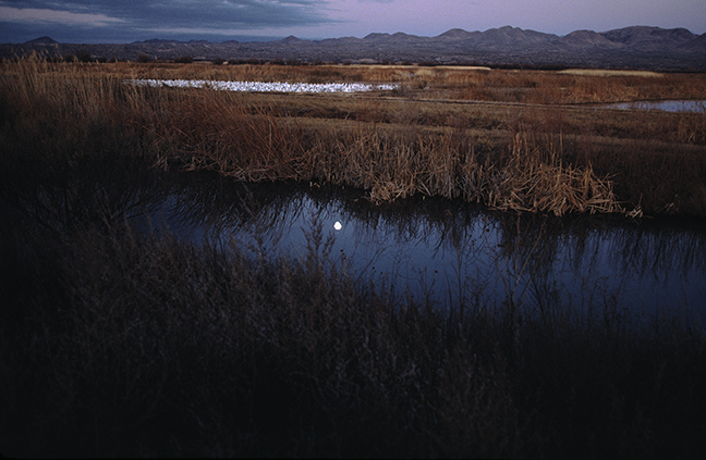
The Bosque del Apache National Wildlife Refuge is situated between the Chupadera and San Pascual Mountains in southern New Mexico and features a wild stretch of the Rio Grande. In the 1930s, the Civilian Conservation Corps began to restore the floodplains in the area as wildlife habitat and in 1939, President Franklin Delano Roosevelt established the Refuge as part of a national system of lands dedicated to wildlife protection. In the winter, when the refuge is at its peak, thousands of geese rise en masse at sunrise and fly low to the north to spend the day feeding in the fields amidst thousands of wintering Sandhill Cranes.
©Rich Beckman

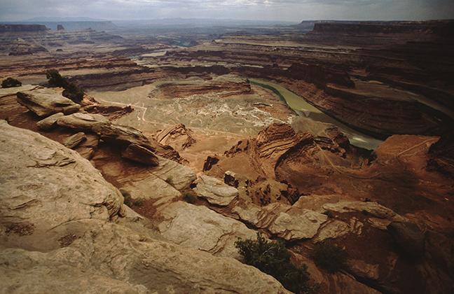
Dead Horse Point sits atop a high plateau about 6,000 feet above sea level and 2,000 feet above the Colorado River providing a panoramic view of Canyonlands' National Park. From the Point, it is possible to see 8,000 feet and 300 million years of geologic history, looking from the peaks of the 12,000-foot high La Sal Mountains to the river below. The legend of Dead Horse Point states that a corral for wild mustangs existed at the site in the early 1900s and for unknown reasons, horses were left corralled on the waterless point and died of thirst within view of the Colorado River 2,000 feet below.
©Rich Beckman

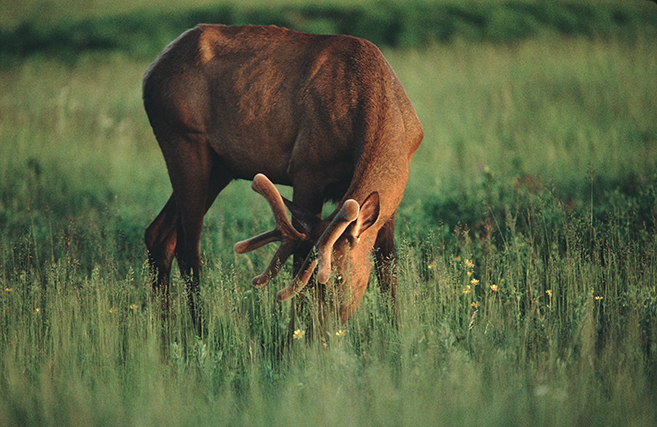
A young bull Rocky Mountain Elk grazes in the National Bison Range National Wildlife Refuge in northwest Montana. Bulls shed and grow their antlers every year and spring antlers (pictured) are covered in velvet. Only males have antlers. President Theodore Roosevelt established the National Bison Range on May 23, 1908 when he authorized funds to purchase land for the conservation of bison. It was the first time that Congress appropriated tax dollars to buy land specifically to conserve wildlife. The Refuge was populated through the donation of 40 buffalo in the early 1900s and today, is home to 300-400 bison as well as Rocky Mountain Elk, Mule Deer, White-tailed Deer, Pronghorn Antelope and Bighorn Sheep.
©Rich Beckman

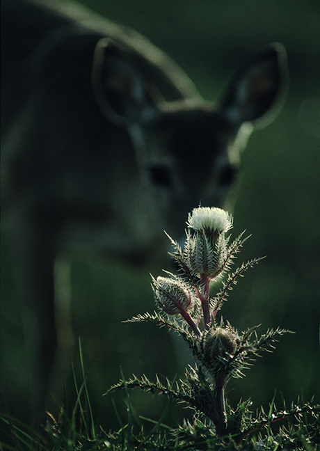
A Mule Deer grazes at dawn behind a sunlit thistle plant in the grasslands of southern Wyoming. Mule Deer are slower, stockier, have larger ears and are blander in color than White-tailed deer, with their gray coloration providing a degree of camouflage from predators, including cougars and coyotes. They do not run as other deer, but have a distinctive bounding leap (stotting) with all four feet coming down together.
©Rich Beckman

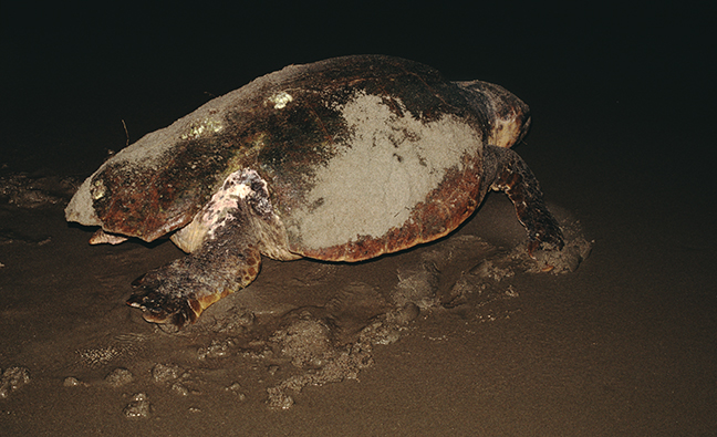
A female Loggerhead Turtle returns to the ocean after laying her eggs on the beach at Bald Head Island, North Carolina. Females reach maturity at about 35 years of age and return to lay eggs in three to six nests at intervals of 12–17 days during the nesting season, on or near the beach where they hatched. They excavate an egg chamber with their hind limbs, in an area above the high-tide line, into which the eggs are deposited. They then cover the egg chamber and body pit with sand and return to the sea. This process takes up to two hours and an average clutch size exceeds 110 eggs.
Loggerheads are the most abundant of the marine turtle species in the United States, but their populations continue to decline due to pollution, shrimp trawling and coastal development. They are the largest of all hard-shelled turtles, with adults weighing an average of 400 pounds. They are listed as Endangered (facing a very high risk of extinction in the wild in the near future) by the International Union for Conservation of Nature and Natural Resources.
©Rich Beckman

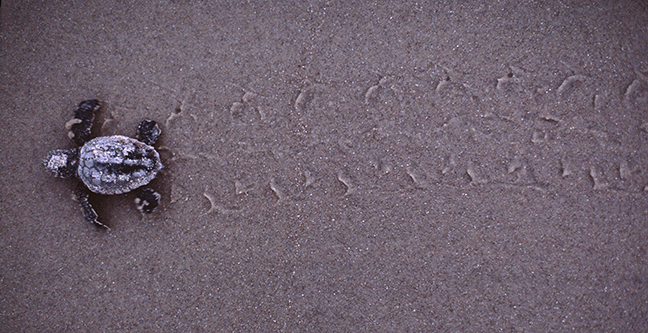
After incubating for approximately 80 days, Loggerhead Turtle hatchlings dig through the sand to the surface and navigate to the brightest horizon, hopefully created by the reflection of the moon and stars off the water's surface. With increased costal development along breeding beaches, hatchlings often head to artificial light sources affiliated with development and do not escape predation or dehydration. Sex of hatchlings is determined by incubation temperature. Warmer temperatures result in the great majority being females and cooler temperatures produce mainly males.
©Rich Beckman

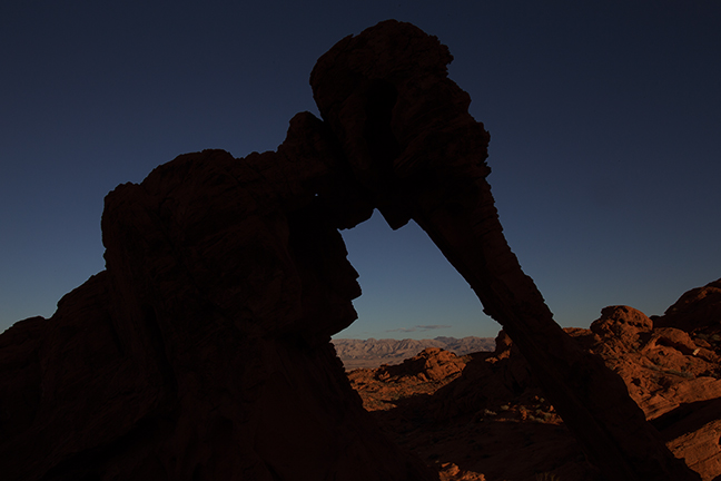
Elephant Rock, Valley of Fire State Park
Approximately 58 miles northeast of Las Vegas, in the Mojave Desert, is Nevada’s oldest and largest state park, dedicated in 1935. The park was named for its red Aztec Sandstone formations that were formed from shifting sand dunes during the Mesozoic Era, more than 150 million years ago. The Anasazi who farmed in the nearby Moapa Valley, occupied the region from 300 BC to 1150 AD. (1/5)
©Rich Beckman
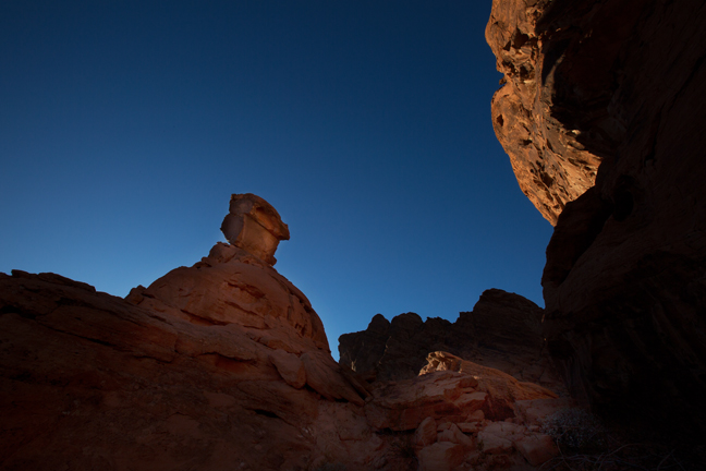
Balanced Rock, Valley of Fire State Park
Approximately 58 miles northeast of Las Vegas, in the Mojave Desert, is Nevada’s oldest and largest state park, dedicated in 1935. The park was named for its red Aztec Sandstone formations that were formed from shifting sand dunes during the Mesozoic Era, more than 150 million years ago. The Anasazi who farmed in the nearby Moapa Valley, occupied the region from 300 BC to 1150 AD. (2/5)
©Rich Beckman
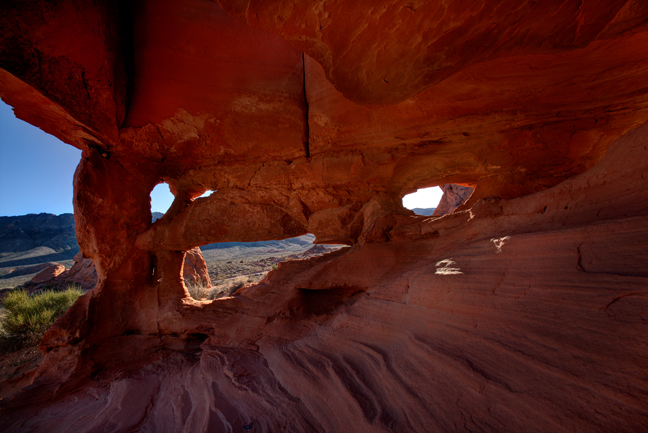
Unnamed 1, Valley of Fire State Park
Approximately 58 miles northeast of Las Vegas, in the Mojave Desert, is Nevada’s oldest and largest state park, dedicated in 1935. The park was named for its red Aztec Sandstone formations that were formed from shifting sand dunes during the Mesozoic Era, more than 150 million years ago. The Anasazi who farmed in the nearby Moapa Valley, occupied the region from 300 BC to 1150 AD. (3/5)
©Rich Beckman
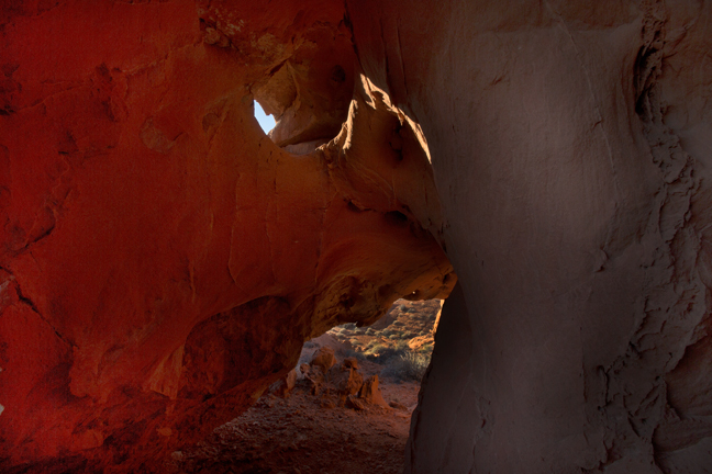
Unnamed 2, Valley of Fire State Park
Approximately 58 miles northeast of Las Vegas, in the Mojave Desert, is Nevada’s oldest and largest state park, dedicated in 1935. The park was named for its red Aztec Sandstone formations that were formed from shifting sand dunes during the Mesozoic Era, more than 150 million years ago. The Anasazi who farmed in the nearby Moapa Valley, occupied the region from 300 BC to 1150 AD. (4/5)
©Rich Beckman
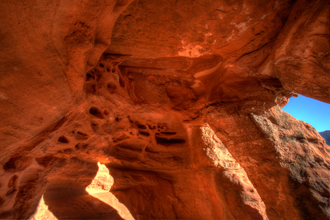
Unnamed 3, Valley of Fire State Park
Approximately 58 miles northeast of Las Vegas, in the Mojave Desert, is Nevada’s oldest and largest state park, dedicated in 1935. The park was named for its red Aztec Sandstone formations that were formed from shifting sand dunes during the Mesozoic Era, more than 150 million years ago. The Anasazi who farmed in the nearby Moapa Valley, occupied the region from 300 BC to 1150 AD. (5/5)
©Rich Beckman

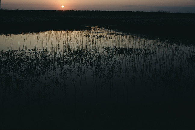
The sun rises over a Texas coastal wetland adjacent to the Attwater Prairie Chicken National Wildlife Refuge near Eagle Lake, Texas. As coastal prairies were plowed under for croplands and pastures in the early 1900s, and cities replaced grasslands and marshes, the populations of many grassland species plummeted. Suppressing prairie fires allowed brush species to invade the remaining prairies and native species were displaced. More than a century ago, there were an estimated one million Attwater’s Prairie Chickens in Texas and Louisiana. Today it is one of the most endangered birds in North America.
©Rich Beckman

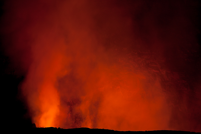
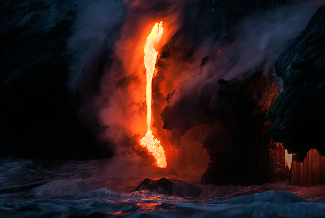
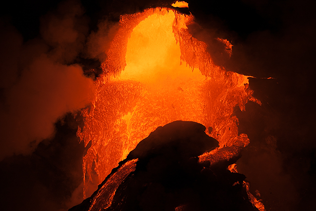
Kilauea, located along the southern shore of the island of Hawaii, is an active shield volcano and the most active of the five volcanoes that form the island of Hawaii. The current Kilauea eruption began on January 3, 1983 and has added more than 500 acres to the island while burying more than nine miles of highway. When the lava flow meets the sea, it vaporizes seawater and creates a dense plume of steam. Over time, the lava builds a delta, extending the shoreline. Kilauea has a 540-foot deep circular caldera at its summit that measures more than three miles across. Legend states that Kilauea is the home of Pele, the volcano goddess of ancient Hawaiian legends. (1/3)
©Rich Beckman

Kilauea, located along the southern shore of the island of Hawaii, is an active shield volcano and the most active of the five volcanoes that form the island of Hawaii. The current Kilauea eruption began on January 3, 1983 and has added more than 500 acres to the island while burying more than nine miles of highway. When the lava flow meets the sea, it vaporizes seawater and creates a dense plume of steam. Over time, the lava builds a delta, extending the shoreline. Kilauea has a 540-foot deep circular caldera at its summit that measures more than three miles across. Legend states that Kilauea is the home of Pele, the volcano goddess of ancient Hawaiian legends. (2/3)
©Rich Beckman

Kilauea, located along the southern shore of the island of Hawaii, is an active shield volcano and the most active of the five volcanoes that form the island of Hawaii. The current Kilauea eruption began on January 3, 1983 and has added more than 500 acres to the island while burying more than nine miles of highway. When the lava flow meets the sea, it vaporizes seawater and creates a dense plume of steam. Over time, the lava builds a delta, extending the shoreline. Kilauea has a 540-foot deep circular caldera at its summit that measures more than three miles across. Legend states that Kilauea is the home of Pele, the volcano goddess of ancient Hawaiian legends. (3/3)
©Rich Beckman


As the moon passes in front of the sun during a total solar eclipse, an effect known as Bailey’s Beads, named after the British astronomer Francis Baily who discovered them, can be observed. Light shines through or is blocked by the mountains, valleys and craters of the moon forming a broken ring of light resembling a necklace of beads.
©Rich Beckman