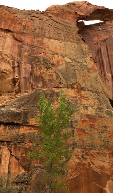
Covered Wagon Bridge (12S 450373 4168578, 37 39.783' -111 33.760'', 24 feet x 10 feet), Alvey Wash, Grand Staircase Escalante National Monument, UT.
©Rich Beckman
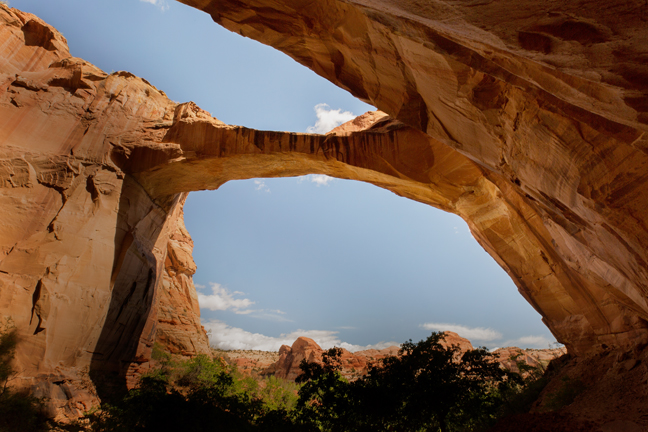
Escalante Bridge (12S 460830 4180679, 37 46.356' -111 26.686', 125 feet x 100 feet), Escalante Canyon, UT
©Rich Beckman
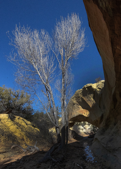
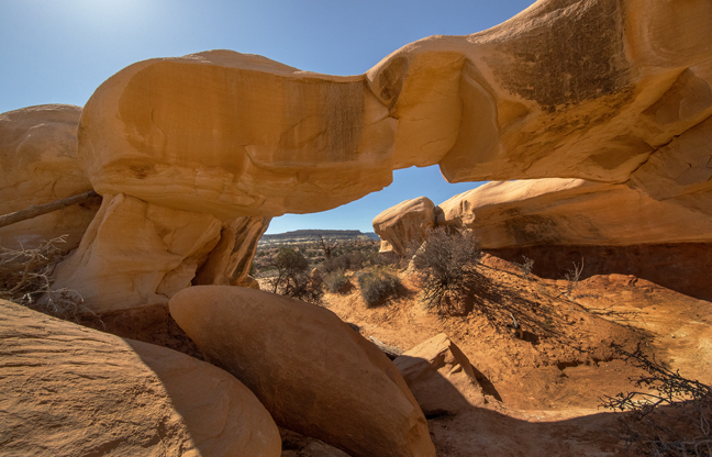
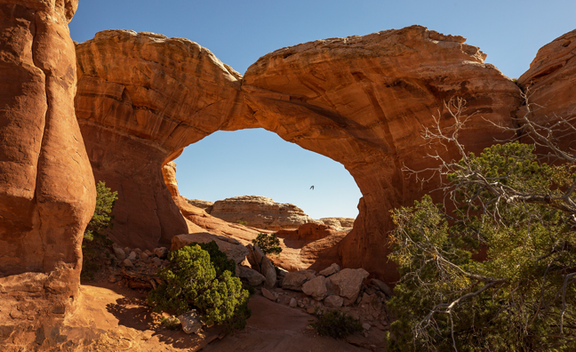
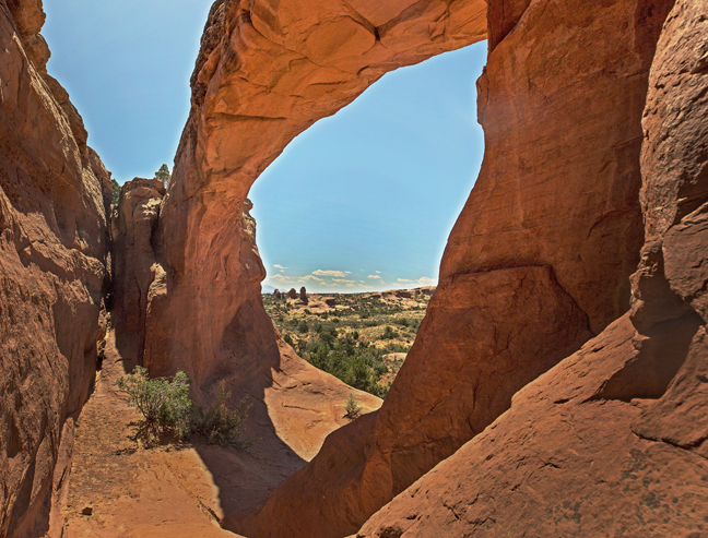
Skyline Arch, Escalante River Trail, Grand Staircase-Escalante National Monument
A short distance beyond Escalante Bridge is Skyline Arch. It is adjacent to an Anasazi ruin and rock art panel approximately 50 feet above the river bed.
©Rich Beckman
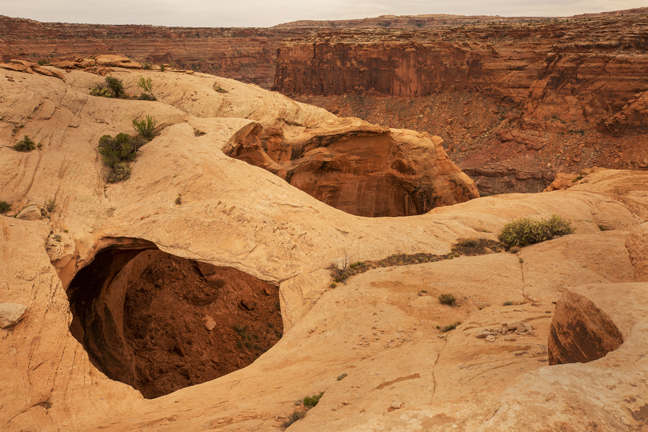
Devil's Garden, Hole-in-the-Rock Road, Grand Staircase-Escalante National Monument
Devils Garden is located on Hole-in-the-Rock Road in Grand Staircase-Escalante National Monument. 12 miles from Highway 12.
©Rich Beckman
Mano Arch (12S 463468 E 4160004, 37 35.182' -111 24.826', 25 x 11 feet) Devil's Garden, Hole-in-the-Rock Road, Grand Staircase-Escalante National Monument
Devils Garden is located on Hole-in-the-Rock Road in Grand Staircase-Escalante National Monument, 12 miles from Highway 12.
©Rich Beckman
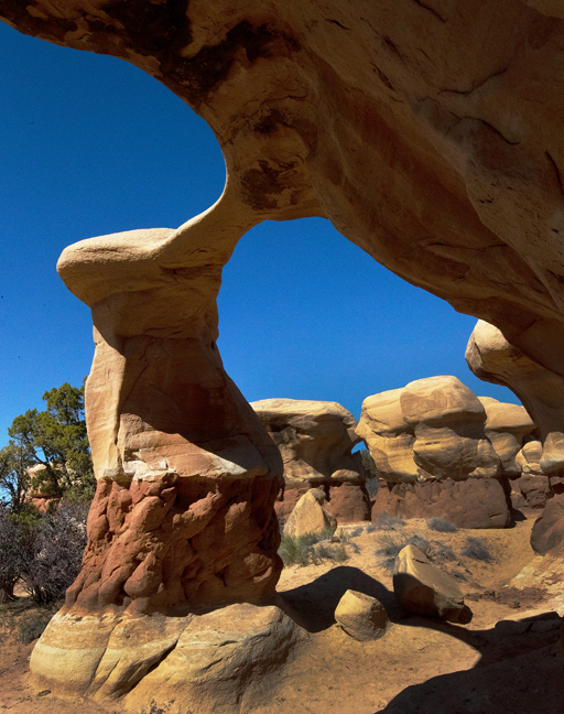
Metate Arch (12S 463529 4159719, 37 35.028' -111 24.785', 22 x 16 feet) Devil's Garden, Hole-in-the-Rock Road, Grand Staircase-Escalante National Monument
Devils Garden is located on Hole-in-the-Rock Road in Grand Staircase-Escalante National Monument, 12 miles from Highway 12.
©Rich Beckman
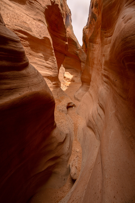
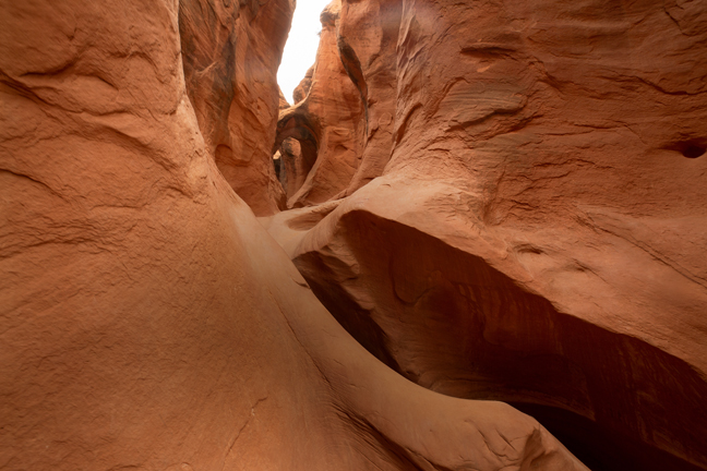
Peek-a-Boo and Spooky Gulch, Hole-in-the-Rock Road, Grand Staircase-Escalante National Monument
Peek-a-boo Gulch is a short slot canyon in the Dry Fork area of the Grand Staircase- Escalante located off Hole-in-the-Rock Road, 26 miles south of the town of Escalante. Peek-a-boo is not very long, but requires some climbing and scrambling to navigate. When exiting Pee-a-Boo, hike overland to the east for half a mile to enter Spooky Gulch back down to Dry Fork and then up to the parking area. The total route is about 3.5 miles.
©Rich Beckman
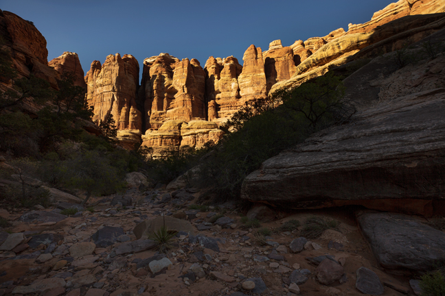
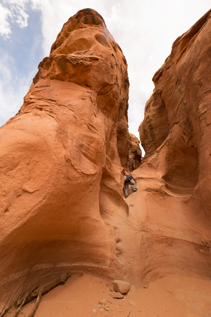
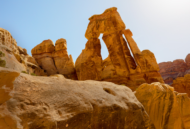
Druid Arch Trail, Needles District, Canyonlands National Park
The day before the Spring 2018 NABS Arch Rally in Moab, UT. Cynny and I spent the afternoon hiking to Druid Arch in Canyonlands National Park, a 10.4 mile out-and-back hike with 1,633 feet of elevation gain, assuming you don't miss any turns (we did). The arch is at the mid-point and requires a good amount of rock scrambling to reach. It's a beautiful iconic arch, one of many in the Needles District of Canyonlands National Park.
©Rich Beckman
Broken Arch (12S 623565 4292395, 53 x 41 feet), NABS Rally, Devils Garden, Arches National Park
It's a good day's drive from Tucson to the red rocks regions of Northern Arizona and Southern Utah, but every time I consider complaining about the drive, I remind myself that a good day's drive from Miami got us to Pensacola or Savannah and that required never leaving the Interstate.
Every night for the ten years we lived in Miami, I took Kodiak out for a walk and looked up at a sky with no stars. I always knew that I would never again live in a place without stars. My photography days begin in the early evening and end shortly after sunrise. The warm evening and morning light, the long soft shadows and the reflected light of the night define my images.
Even before leaving Florida, I'd been the designer and editor of SPAN, the quarterly magazine of the Natural Arch and Bridge Society (NABS, http://www.naturalarches.org). Up until early May, I had only met one other member of NABS, David Brandt-Erichsen, the Society's Webmaster and a former editor and publisher of SPAN, as we both live in Tucson. He is one of the outstanding people, along with David Kennedy (also a former editor) who help me edit SPAN. Both have seen, climbed to and documented many more arches than I will ever see or photograph during my lifetime.
Every year, NABS holds two rallies for their members. A rally consists of eight days of hiking to see natural arches and bridges within a selected region, usually in the Southwest. The rallies are in early May and October, so were never feasible with my previous academic schedule. The Spring 2018 Rally was in Moab, Utah: gateway to Arches and Canyonlands National Parks.
Many of the hikes were outside of the National Parks and required high clearance four-wheel drive vehicles to reach the trailheads. These folks are serious about their vehicles and their arches and can hike and scramble with anyone. Within the group are mountaineers who summited Everest, Denali, Chimborazo and Kilimanjaro; Vietnam War veterans, a former Marine, a retired physics and astronomy professor, the creator of the World Arch Database and accomplished artisans, all of whom know every rock on "roads" that I never even knew existed.
One thing you realize quickly when you live in the Southwest is that there is rarely a paved road to where you want to go, but that there are ways to get almost anywhere. The Shafer Trail, Hole-in-the-Rock Road, Behind the Rocks Road, Toroweap Overlook Road, House Rock Road and hundreds of others are all unpaved and often ungraded gateways to paradise.
I can't keep up with world-class mountaineers on the trail, I don’t have access to Native Lands and I'm an amateur at navigating with my GPS and topographical maps. However, because of the kindness of NABS members, I'm slowly learning these essential skills.
©Rich Beckman
Sand Dune Arch (12S 623253 4291578, 25 x 11.5 feet), NABS Rally, Devils Garden, Arches National Park
It's a good day's drive from Tucson to the red rocks regions of Northern Arizona and Southern Utah, but every time I consider complaining about the drive, I remind myself that a good day's drive from Miami got us to Pensacola or Savannah and that required never leaving the Interstate.
Every night for the ten years we lived in Miami, I took Kodiak out for a walk and looked up at a sky with no stars. I always knew that I would never again live in a place without stars. My photography days begin in the early evening and end shortly after sunrise. The warm evening and morning light, the long soft shadows and the reflected light of the night define my images.
Even before leaving Florida, I'd been the designer and editor of SPAN, the quarterly magazine of the Natural Arch and Bridge Society (NABS, http://www.naturalarches.org). Up until early May, I had only met one other member of NABS, David Brandt-Erichsen, the Society's Webmaster and a former editor and publisher of SPAN, as we both live in Tucson. He is one of the outstanding people, along with David Kennedy, also a former editor, who help me edit SPAN. Both have seen, climbed to and documented many more arches than I will ever see or photograph during my lifetime.
Every year, NABS holds two rallies for their members. A rally consists of eight days of hiking to see natural arches and bridges within a selected region, usually in the Southwest. The rallies are in early May and October, so were never feasible with my previous academic schedule. The Spring 2018 Rally was in Moab, Utah: gateway to Arches and Canyonlands National Parks.
Many of the hikes were outside of the National Parks and required high clearance four-wheel drive vehicles to reach the trailheads. These folks are serious about their vehicles and their arches and can hike and scramble with anyone. Within the group are mountaineers who summited Everest, Denali, Chimborazo and Kilimanjaro; Vietnam War veterans, a former Marine, a retired physics and astronomy professor, the creator of the World Arch Database and accomplished artisans, all of whom know every rock on "roads" that I never even knew existed.
One thing you realize quickly when you live in the Southwest is that there is rarely a paved road to where you want to go, but that there are ways to get almost anywhere. The Shafer Trail, Hole-in-the-Rock Road, Behind the Rocks Road, Toroweap Overlook Road, House Rock Road and hundreds of others are all unpaved and often ungraded gateways to paradise.
I can't keep up with world-class mountaineers on the trail, I don’t have access to Native Lands and I'm an amateur at navigating with my GPS and topographical maps. However, because of the kindness of NABS members, I'm slowly learning these essential skills.
©Rich Beckman
The Ghost of Slit Window Arch (12S 605837 4276254, 40 x 3 feet), Upper Sevenmile Canyon area, Moab, UT
It's a good day's drive from Tucson to the red rocks regions of Northern Arizona and Southern Utah, but every time I consider complaining about the drive, I remind myself that a good day's drive from Miami got us to Pensacola or Savannah and that required never leaving the Interstate.
Every night for the ten years we lived in Miami, I took Kodiak out for a walk and looked up at a sky with no stars. I always knew that I would never again live in a place without stars. My photography days begin in the early evening and end shortly after sunrise. The warm evening and morning light, the long soft shadows and the reflected light of the night define my images.
Even before leaving Florida, I'd been the designer and editor of SPAN, the quarterly magazine of the Natural Arch and Bridge Society (NABS, http://www.naturalarches.org). Up until early May, I had only met one other member of NABS, David Brandt-Erichsen, the Society's Webmaster and a former editor and publisher of SPAN, as we both live in Tucson. He is one of the outstanding people, along with David Kennedy, also a former editor, who help me edit SPAN. Both have seen, climbed to and documented many more arches than I will ever see or photograph during my lifetime.
Every year, NABS holds two rallies for their members. A rally consists of eight days of hiking to see natural arches and bridges within a selected region, usually in the Southwest. The rallies are in early May and October, so were never feasible with my previous academic schedule. The Spring 2018 Rally was in Moab, Utah: gateway to Arches and Canyonlands National Parks.
Many of the hikes were outside of the National Parks and required high clearance four-wheel drive vehicles to reach the trailheads. These folks are serious about their vehicles and their arches and can hike and scramble with anyone. Within the group are mountaineers who summited Everest, Denali, Chimborazo and Kilimanjaro; Vietnam War veterans, a former Marine, a retired physics and astronomy professor, the creator of the World Arch Database and accomplished artisans, all of whom know every rock on "roads" that I never even knew existed.
One thing you realize quickly when you live in the Southwest is that there is rarely a paved road to where you want to go, but that there are ways to get almost anywhere. The Shafer Trail, Hole-in-the-Rock Road, Behind the Rocks Road, Toroweap Overlook Road, House Rock Road and hundreds of others are all unpaved and often ungraded gateways to paradise.
I can't keep up with world-class mountaineers on the trail, I don’t have access to Native Lands and I'm an amateur at navigating with my GPS and topographical maps. However, because of the kindness of NABS members, I'm slowly learning these essential skills.
©Rich Beckman
Crumbling Arch (12S 603280 4253752, 8 x 6 feet), NABS Rally, Island in the Sky District, Canyonlands National Park
It's a good day's drive from Tucson to the red rocks regions of Northern Arizona and Southern Utah, but every time I consider complaining about the drive, I remind myself that a good day's drive from Miami got us to Pensacola or Savannah and that required never leaving the Interstate.
Every night for the ten years we lived in Miami, I took Kodiak out for a walk and looked up at a sky with no stars. I always knew that I would never again live in a place without stars. My photography days begin in the early evening and end shortly after sunrise. The warm evening and morning light, the long soft shadows and the reflected light of the night define my images.
Even before leaving Florida, I'd been the designer and editor of SPAN, the quarterly magazine of the Natural Arch and Bridge Society (NABS, http://www.naturalarches.org). Up until early May, I had only met one other member of NABS, David Brandt-Erichsen, the Society's Webmaster and a former editor and publisher of SPAN, as we both live in Tucson. He is one of the outstanding people, along with David Kennedy, also a former editor, who help me edit SPAN. Both have seen, climbed to and documented many more arches than I will ever see or photograph during my lifetime.
Every year, NABS holds two rallies for their members. A rally consists of eight days of hiking to see natural arches and bridges within a selected region, usually in the Southwest. The rallies are in early May and October, so were never feasible with my previous academic schedule. The Spring 2018 Rally was in Moab, Utah: gateway to Arches and Canyonlands National Parks.
Many of the hikes were outside of the National Parks and required high clearance four-wheel drive vehicles to reach the trailheads. These folks are serious about their vehicles and their arches and can hike and scramble with anyone. Within the group are mountaineers who summited Everest, Denali, Chimborazo and Kilimanjaro; Vietnam War veterans, a former Marine, a retired physics and astronomy professor, the creator of the World Arch Database and accomplished artisans, all of whom know every rock on "roads" that I never even knew existed.
One thing you realize quickly when you live in the Southwest is that there is rarely a paved road to where you want to go, but that there are ways to get almost anywhere. The Shafer Trail, Hole-in-the-Rock Road, Behind the Rocks Road, Toroweap Overlook Road, House Rock Road and hundreds of others are all unpaved and often ungraded gateways to paradise.
I can't keep up with world-class mountaineers on the trail, I don’t have access to Native Lands and I'm an amateur at navigating with my GPS and topographical maps. However, because of the kindness of NABS members, I'm slowly learning these essential skills.
©Rich Beckman
Tapestry Arch (12S 622897 4293071, 46 x 13 feet), NABS Rally, South Devils Garden area, Arches National Park
It's a good day's drive from Tucson to the red rocks regions of Northern Arizona and Southern Utah, but every time I consider complaining about the drive, I remind myself that a good day's drive from Miami got us to Pensacola or Savannah and that required never leaving the Interstate.
Every night for the ten years we lived in Miami, I took Kodiak out for a walk and looked up at a sky with no stars. I always knew that I would never again live in a place without stars. My photography days begin in the early evening and end shortly after sunrise. The warm evening and morning light, the long soft shadows and the reflected light of the night define my images.
Even before leaving Florida, I'd been the designer and editor of SPAN, the quarterly magazine of the Natural Arch and Bridge Society (NABS, http://www.naturalarches.org). Up until early May, I had only met one other member of NABS, David Brandt-Erichsen, the Society's Webmaster and a former editor and publisher of SPAN, as we both live in Tucson. He is one of the outstanding people, along with David Kennedy, also a former editor, who help me edit SPAN. Both have seen, climbed to and documented many more arches than I will ever see or photograph during my lifetime.
Every year, NABS holds two rallies for their members. A rally consists of eight days of hiking to see natural arches and bridges within a selected region, usually in the Southwest. The rallies are in early May and October, so were never feasible with my previous academic schedule. The Spring 2018 Rally was in Moab, Utah: gateway to Arches and Canyonlands National Parks.
Many of the hikes were outside of the National Parks and required high clearance four-wheel drive vehicles to reach the trailheads. These folks are serious about their vehicles and their arches and can hike and scramble with anyone. Within the group are mountaineers who summited Everest, Denali, Chimborazo and Kilimanjaro; Vietnam War veterans, a former Marine, a retired physics and astronomy professor, the creator of the World Arch Database and accomplished artisans, all of whom know every rock on "roads" that I never even knew existed.
One thing you realize quickly when you live in the Southwest is that there is rarely a paved road to where you want to go, but that there are ways to get almost anywhere. The Shafer Trail, Hole-in-the-Rock Road, Behind the Rocks Road, Toroweap Overlook Road, House Rock Road and hundreds of others are all unpaved and often ungraded gateways to paradise.
I can't keep up with world-class mountaineers on the trail, I don’t have access to Native Lands and I'm an amateur at navigating with my GPS and topographical maps. However, because of the kindness of NABS members, I'm slowly learning these essential skills.
©Rich Beckman
Cliffhanger Arch (12S 583417 4275803, 38 37.610' -110 2.501', 60 x 30 feet), NABS Rally, Arches National Park
It's a good day's drive from Tucson to the red rocks regions of Northern Arizona and Southern Utah, but every time I consider complaining about the drive, I remind myself that a good day's drive from Miami got us to Pensacola or Savannah and that required never leaving the Interstate.
Every night for the ten years we lived in Miami, I took Kodiak out for a walk and looked up at a sky with no stars. I always knew that I would never again live in a place without stars. My photography days begin in the early evening and end shortly after sunrise. The warm evening and morning light, the long soft shadows and the reflected light of the night define my images.
Even before leaving Florida, I'd been the designer and editor of SPAN, the quarterly magazine of the Natural Arch and Bridge Society (NABS, http://www.naturalarches.org). Up until early May, I had only met one other member of NABS, David Brandt-Erichsen, the Society's Webmaster and a former editor and publisher of SPAN, as we both live in Tucson. He is one of the outstanding people, along with David Kennedy, also a former editor, who help me edit SPAN. Both have seen, climbed to and documented many more arches than I will ever see or photograph during my lifetime.
Every year, NABS holds two rallies for their members. A rally consists of eight days of hiking to see natural arches and bridges within a selected region, usually in the Southwest. The rallies are in early May and October, so were never feasible with my previous academic schedule. The Spring 2018 Rally was in Moab, Utah: gateway to Arches and Canyonlands National Parks.
Many of the hikes were outside of the National Parks and required high clearance four-wheel drive vehicles to reach the trailheads. These folks are serious about their vehicles and their arches and can hike and scramble with anyone. Within the group are mountaineers who summited Everest, Denali, Chimborazo and Kilimanjaro; Vietnam War veterans, a former Marine, a retired physics and astronomy professor, the creator of the World Arch Database and accomplished artisans, all of whom know every rock on "roads" that I never even knew existed.
One thing you realize quickly when you live in the Southwest is that there is rarely a paved road to where you want to go, but that there are ways to get almost anywhere. The Shafer Trail, Hole-in-the-Rock Road, Behind the Rocks Road, Toroweap Overlook Road, House Rock Road and hundreds of others are all unpaved and often ungraded gateways to paradise.
I can't keep up with world-class mountaineers on the trail, I don’t have access to Native Lands and I'm an amateur at navigating with my GPS and topographical maps. However, because of the kindness of NABS members, I'm slowly learning these essential skills.
©Rich Beckman