We live in the beautiful Sonoran Desert, so when the temperatures consistently reach triple digits, we migrate and explore.
There is very little that is random on our itineraries since we strive to reach select wilderness destinations in the best light for photography. Coastal hikes often require low tides that correlate with sunrise or sunset and inland hikes to natural arches, waterfalls and other destinations that require long drives or hikes, often require pre-dawn departures to reach destinations before the light becomes too harsh and the temperatures too hot.
Even then, as Joni Michell wrote and Judy Collins first recorded, there are those pesky clouds:
“But now they only block the sun
They rain and they snow on everyone
So many things I would have done
But clouds got in my way.”
In mid-June, we headed west to the Colorado Desert in southern California, then up the California coast before cutting inland to Pinnacles National Park and Mt. Shasta. From there, we traveled across southern Oregon before dropping down into southeast Idaho, northeast Utah and across to western Colorado for a week in the Fruita area. Afterwards we stopped in Boulder, Denver, Littleton and Del Norte, Colorado before heading into New Mexico where we made stops in Taos, Las Vegas, Abiquiu and Counselor before crossing back into Arizona, and arriving home.
Details are within the slide shows, but thanks to our friends and relatives: Libby, Sarah and Jason, Jim, Guy and Lisa, Steven, Bonnie and Myra, Karen and David, Marilyn and Joel, David and Judy, Ross, Kate and Greg, Bob and Carol, another Carol and Peter who fed us, housed us, hiked with us and guided us. We loved spending time with you all.
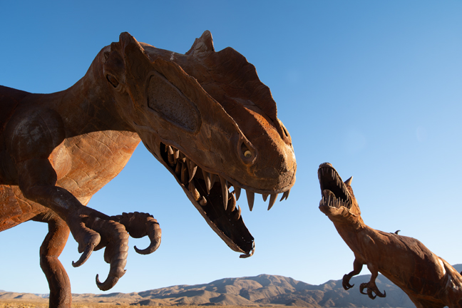
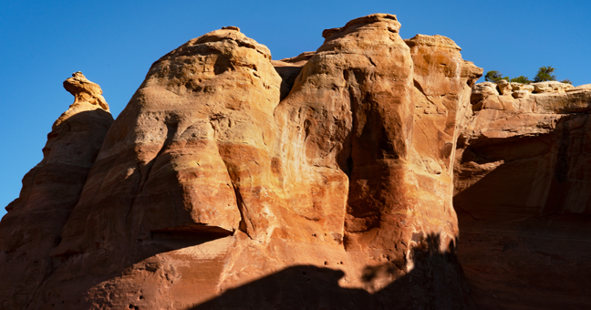
Fighting Dinosaurs, Galleta Meadows, Borrego Springs, CA
Our first stop was Borrego Springs, CA, a community of less than 2,000 year-round residents that is completely surrounded by Anza Borrego Desert State Park, the largest state park in California.
Between 2008 and 2012, philanthropist Dennis Avery commissioned artist Ricardo Breceda to design and build the 131 metal sculptures of dinosaurs and other creatures, many based on species that had once roamed Borrego Springs and other parts of Southern California. They remain scattered around the properties he owned in Borrego Valley, which he called Galleta Meadows. Avery was heir to the fortune from the Avery Dennison Corporation (formerly the Avery Adhesive Label Corporation) and died in 2012. He and his wife lived in Borrego Springs, 90 miles from San Diego, where he had worked for the city attorney’s office as one of its first consumer fraud attorneys.
The fighting dinosaurs depicted in this sculpture, Allosaurus (left) and Carnotaurus (right) never actually encountered one another. Allosaurus lived in the Jurassic period and inhabited Africa, Europe and North America. Carnotaurus lived in South America during the Late Cretaceous period.
©Rich Beckman
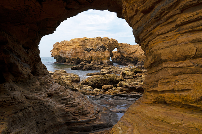
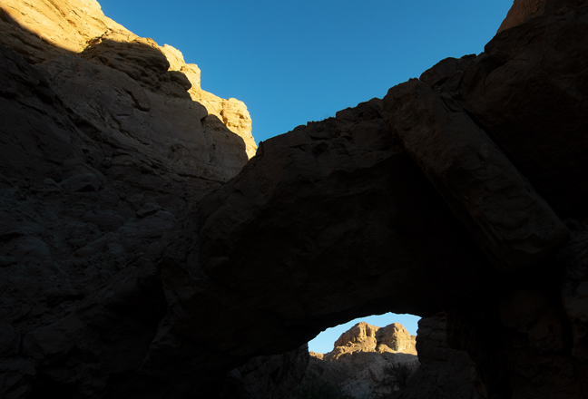
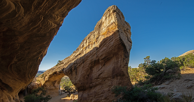
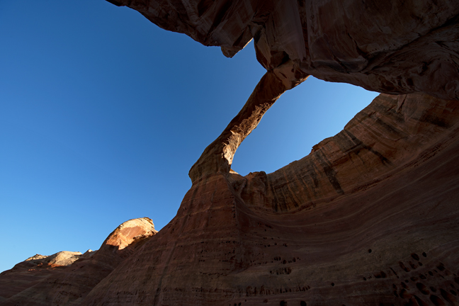
Coral Wash Bridge (11S-0592369-3685317, 12’x10’)
Coral Wash Bridge is in the Truckhaven area of Ocotillo Wells State Vehicular Recreation Area, about 1.6 miles west of State Highway 86 in a sandy wash. It is between Anza Borrego Desert State Park and the Salton Sea. You can drive to and under the arch with 4WD.
©Rich Beckman
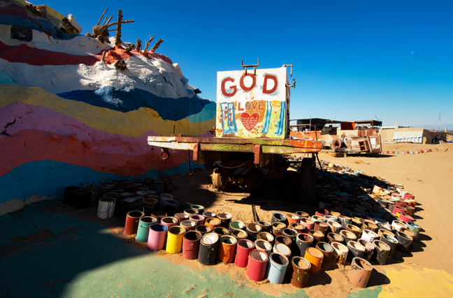
Salvation Mountain, Imperial County, CA
Salvation Mountain, was created from adobe bricks, discarded tires, windows and automobile parts by Leonard Knight beginning in 1984. It features numerous murals that incorporate Bible verses and Christian sayings based on the Sinner’s Prayer. Knight died in 2014 after spending the last 30 years of his life working on the 50 foot-tall mountain. He slept at the base of the mountain in the back of his pick-up truck. The religious folk art now serves as a centerpiece for Slab City, a squatter art community, and is managed by a public charity. Much of it was inaccessible and in need of repair when we visited in June 2022. (1/2)
©Rich Beckman
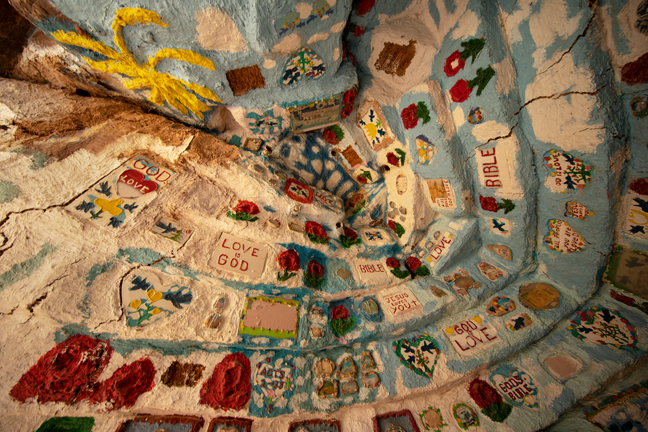
Interior Room, Salvation Mountain, Imperial County, CA
Salvation Mountain, was created from adobe bricks, discarded tires, windows and automobile parts by Leonard Knight beginning in 1984. It features numerous murals that incorporate Bible verses and Christian sayings based on the Sinner’s Prayer. Knight died in 2014 after spending the last 30 years of his life working on the 50 foot-tall mountain. He slept at the base of the mountain in the back of his pick-up truck. The religious folk art now serves as a centerpiece for Slab City, a squatter art community, and is managed by a public charity. Much of it was inaccessible and in need of repair when we visited in June 2022. (2/2)
©Rich Beckman
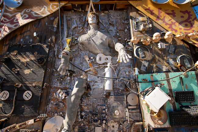
Art Garden at East Jesus, Slab City, CA
The entrance to The Art Garden at East Jesus is just north of Salvation Mountain. The outdoor gallery is open and free, sunrise to sunset, 365 days a year. It is the only art museum in Imperial County and is run solely on donations (http://eastjesus.org/art-garden/). It describes itself as an experimental, habitable, extensible artwork in progress.
Before you visit East Jesus, it is important to read the East Jesus Survival Guide (http://eastjesus.org/east-jesus-survival-guide). Here is one of my favorite sections that will help you understand why this is important:
“EAST JESUS IS NOT A FUCKING ASHTRAY. Smoking is permitted. Go ahead, they’re your lungs. IF WE FIND ONE SINGLE BUTT ON THE GROUND WE WILL FUCKING KILL YOU. That means you will be dead, and it will hurt like hell the whole time you’re dying.… If you knew how many times we’ve bent over to pick up butts, and how much it hurts when we do this, and how much the sight of cigarette butts on the ground fills us with murderous bile, you would understand.”
Upon our arrival, we were immediately met by one of the contributing artists. He explained that the inhabitants of East Jesus provide a refuge for artists, musicians, survivalists, writers, scientists, laymen and other wandering geniuses who are dedicated to providing a working model of an improbable improvised community at the edge of the world. I highly recommend you visit if you happen to be in the area. Actually, you’re never likely to just happen to be in the area, so go out of your way to visit.
©Rich Beckman
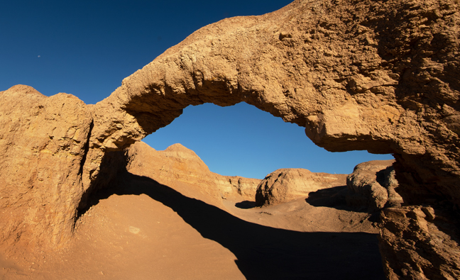
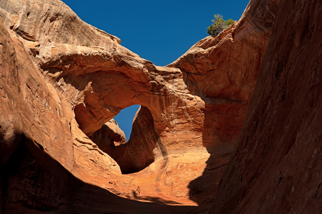
Palm Wash Arch (11S-0583246-3683158, 19’x8’)
Palm Wash Arch is near the 4WD parking area for the South Fork Palm Wash Canyon Trailhead in Anza Borrego Desert State Park. The trail, that goes under the arch and through a slot canyon, is a four-mile out and back if you walk from the main road (Borrego Salton Sea Way, S22) or a 2.8 mile out and back from the 4WD parking area at the start of the slot canyon. The arch is in shadow until late morning as the sun is blocked by the cliff wall to the east.
©Rich Beckman
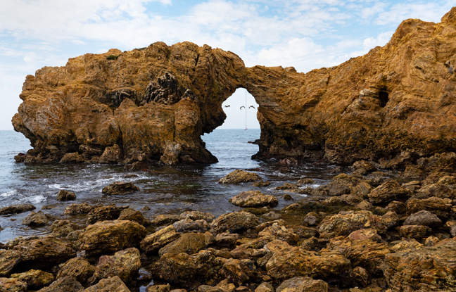
Arch Rock 7, V21-36 (11S-419806-3716430, 15’x20’), Cliff Island, Little Corona Del Mar Beach, CA
After spending a day in Irvine, CA with Aunt Libby, we headed out to Little Corona Del Mar Beach the next morning for sunrise. Unfortunately, this was one of those early mornings when “….clouds got in my way.” There were a few moments of sunlight followed by dark clouds, a morning thunderstorm and then more clouds. Fortunately, our timing was impeccable. We watched the sunrise, took a few photographs and were safely sheltered at the Rose Bakery Café for fresh donuts before the rain started.
We waited out the rain and then returned to the beach and made our way to Cliff Island and the arch. It is probably an easy walk during a minus tide, but it was not and the low tide was not until mid-day when the light would be even worse, so we waded through tidal pools and navigated the slippery boulders to a suitable, though not ideal, vantage point. Fortunately, some Brown Pelicans flew by framed by the arch, so it wasn’t a total waste of time and within a few weeks the gashes on my leg had healed nicely.
The rope hanging from the arch is because many visitors cliff jump from the top of the arch. I checked our itinerary, and fortunately, this was not included.
©Rich Beckman
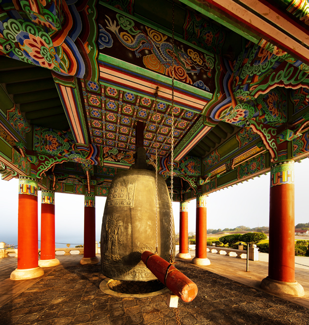
Korean Bell of Friendship, Angels Gate Park, San Pedro, CA
The Korean Bell of Friendship was donated to the people of Los Angeles in 1976 to celebrate the Bicentennial as a way to commemorate and thank the U.S for its participation in the Korean Conflict. It sits on a battery where once a web of catacombs and bunkers housed munitions and men in what was known as the Upper Reservation of Fort MacArthur, now Angels Gate Park. It overlooks the port from which U.S. troops sailed into the Pacific.
Four pairs of figures, each consisting of the Goddess of Liberty and a Korean spirit, are engraved in relief on the body of the bell. Each of the Korean spirits holds a different symbol: a symbolic design of the Korean flag; a branch of the rose of Sharon, Korea’s national flower; a branch of laurel, symbol of victory; and a dove of peace. The bell has no clapper but is struck from the outside with a wooden log.
We didn’t stop in San Pedro to visit the Korean Bell of Friendship, but rather to photograph the Point Fermin Lighthouse and the Queen Mary, in nearby Long Beach Harbor. The famous lighthouse is supposedly open to the public from 1-4 p.m. Tuesday through Sunday, but it isn’t. It’s fenced and the signage says that it’s open by appointment only. It’s unclear why and as it is owned by the City of Los Angeles, there were no answers forthcoming. It’s located in a beautiful coastal park where we enjoyed a nice picnic before exploring San Pedro and seeing the Korean Bell of Friendship. We went to photograph it the next morning at sunrise, but the park was gated and locked. Fortunately, we followed a jogger to an opening through a residential area into the park.
Our visit to the Queen Mary was equally unsuccessful. Although I knew that the former luxury liner was closed for restoration, I didn’t know that the entire area would be roped off and closed to the public. All of the parking lots and access roads were closed and there was nothing to see except miles and miles of shipping containers. The Port of Long Beach moved more than 9.38 million cargo containers in 2021 and is the busiest container port in the Western Hemisphere. Who knew? Who cares?
©Rich Beckman
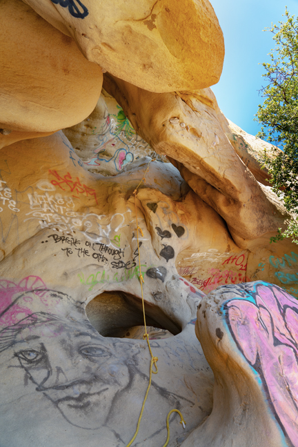
Unnamed Arches (11S-337756-3772662), Corral Canyon Cave, Backbone Trail, Santa Monica Mountains NRA, CA
After lunch with Jim Seida, a colleague who I worked with in at least a half a dozen countries and dinner with my niece Sarah, her husband Jason and their twin daughters Poppy and Goldie, we headed to Agoura Hills, CA, one of the many access points to the Santa Monica Mountains National Recreation Area and the 67-miles Backbone Trail. It crosses the best-protected stretch of coastal Mediterranean habitat in the world and connects Will Rogers State Historic Park in Pacific Palisades with Point Mugu State Park in Ventura County. There are 12 trailheads along the route and the best one for seeing natural arches begins at the end of Corral Canyon Road. The first half mile traverses a large granite outcropping where most of the arches are located. I wish we had known this before we hiked an additional four miles, as the return hike was all uphill.
On May 2, 2016, California State Parks’ Los Angeles District Superintendent Craig Sap sent out a memo that Corral Canyon Cave, better known as Jim Morrison Cave, would be completely closed to the public until further notice: “….The area has become popular with the public after a rumor began through social media that Jim Morrison from The Doors was said to have frequented the location. As a result large crowds have shown up on a daily basis to see the often vandalized cave and in some cases add to the vandalism with graffiti of their own. While State Park Rangers have been successful in catching and arresting several individuals for felony vandalism, however the graffiti of the cave and surrounding area has increased….”
The cave also made news headlines back in November of 2007 when partiers made an illegal campfire and started a wildfire. Nearly 5,000 acres were burned and 50 homes were destroyed.
The dirt parking lot for this hike is located at the end of Corral Canyon road. You turn on Corral Canyon Road from the PCH, the same place you turn for Solstice Canyon, and then head up the small two-lane road for five miles. At the end, it turns into dirt, and you drive about 50 feet on the dirt road before reaching the parking lot that holds about ten cars. The hike starts from the parking lot, on the right-hand side, and heads along the Backbone Trail.
We later learned that there were at least seven unsolved shootings in and adjacent to Malibu Creek State Park between November 2016 and June 2018, including the murder of a camper who was asleep in his tent with his two young daughters. The park is just north of the trail we were hiking.
©Rich Beckman
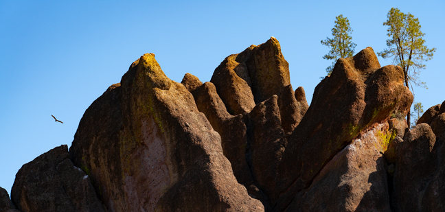
Pinnacles High Peak Loop Trail, Pinnacles National Park, CA
We diverted from our northern trek to spend a night in Pasadena, CA to attend the Los Angeles premiere of “The Human Trial,” a film by Guy Mossman, one of my former graduate students, and his wife Lisa Hepner and to have lunch with Steven Tepper, who is Guy’s brother-in-law, a former colleague from UNC-CH and a friend for more than 30 years. The next morning, we headed north to our campsite at Pinnacles National Park.
The 9.3 mile High Peak Loop Trail traverses many of the major sites within the national park, one of the smallest in the country, encompassing about 42 square miles. In 1908 President Theodore Roosevelt created Pinnacles National Monument and legislation to make it a national park was signed by President Obama on January 10, 2013.
The park is located near the San Andreas fault and The Pinnacles are part of the Neenach Volcano which erupted 23 million years ago.
A California condor re-establishment program has been in place since 2003. The first nest since reintroduction was built in 2010, and Pinnacles now manages a population of 25 free-flying condors. Pinnacles National Park joined the California Condor Recovery Program as a release and management site in 2003. The park co-manages all of the wild condors in central California along with the Ventana Wildlife Society.
In 1967, condors were listed as an endangered species. Despite this protection, their population continued to decrease and dropped to a low of 22 individuals in the 1980s. All wild condors were then trapped and placed in captive breeding programs in an effort to save the species from extinction. As of the end of 2018, there were a total of 488 condors in the world, with 312 of those flying free in the wild.
During our hike we saw numerous large black birds soaring on the early morning thermals amidst The Pinnacles. Most were likely Turkey Vultures, as we didn’t see any birds with tags or transmitters, but some were likely condors. It's a challenging hike, so that's our story and we're sticking to it.
©Rich Beckman
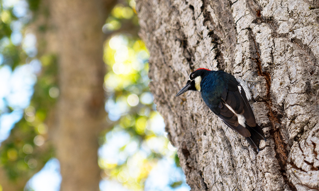
Acorn Woodpecker (Melanerpes formicivorus), Pinnacles National Park, CA
Upon returning to the parking area from hiking the Pinnacles High Peak Trail, we watched an Acorn Woodpecker hunting for bugs on a nearby tree. Acorn Woodpeckers are best known for their behavior of hoarding acorns. They drill small holes in a dead snag, then harvest acorns in the fall and store them in these holes, to be eaten during winter. Such "granary trees" may be used for generations and may be riddled with up to 50,000 holes.
They are also unusual in that they live in large groups and breed cooperatively with multiple males and females combining efforts to raise young in a single nest.
©Rich Beckman
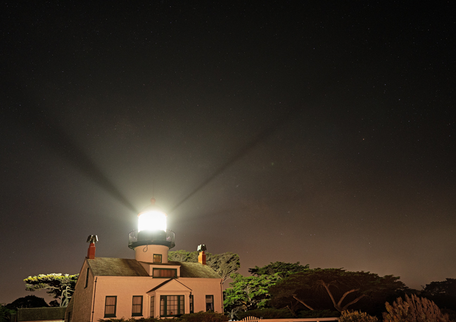
Point Pinos Lighthouse, Pacific Grove, CA
After dinner with friends Bonnie and Myra in Salinas, CA, our next stop was Carmel, CA. to photograph the Point Pinos Lighthouse and Soberanes Arch. The lighthouse is the oldest continually operating lighthouse on the West Coast and on the National Register of Historic Places. The building, lenses and prisms are all original, and it is still an active aid to navigation. Built in 1855, it is one of six lighthouses along the coast for which Congress appropriated funds shortly after California statehood was ratified. Initially, whale oil was used to fuel the light, then in 1880, the lighthouse shifted to kerosene for fuel. In 1919, it was electrified.
Today, the fenced lighthouse is adjacent to a golf course and only open a few hours on weekends and then only if volunteers are available. Otherwise, it is not easy to access and is surrounded by No Trespassing signs, especially at night. The goal was to photograph the lighthouse under the Milky Way, but few stars were visible once the haze moved in from the ocean.
©Rich Beckman
Soberanes Arch (10S-596302-4035231, 12’), Garrapata State Park, Carmel, CA
This famous sea arch is located in the California Sea Otter State Game Reserve in Garrapata State Park, just south of Carmel on State Highway 1 off Soberanes Point. Access to the overlook, which requires following a social trail to the edge of a cliff, was challenging due to high winds.
©Rich Beckman
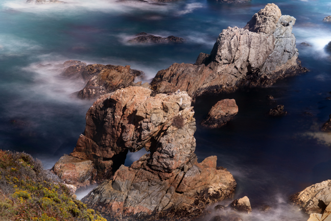
Arch 9-CA-29 (10S-0513730-4206875), Pt. Reyes National Seashore, CA
Our next stop was Pt. Reyes National Seashore where there are numerous sea arches on Sculptured and Secret Beaches, many of which can only be accessed during a minus tide. Unlike the directions we got at the Visitors Center, they can also be accessed by walking on the beach without detouring onto the Coastal Trail. Once we corrected that error, we stalled at a steep drop that required navigating a few slippery boulders. Fortunately, a young couple showed us the way and stood by to make sure we didn’t fall.
An Ochre Sea Star (Pisaster ochraceus) clings to a mussel bed adjacent to sea arch 9-CA-29, one of a series of arches on Sculptured Beach.
©Rich Beckman
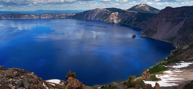
Crater Lake National Park, Crater Lake, OR
We were scheduled to visit Crater Lake National Park last summer, but the nearby wildfires forced us to cancel those plans and reschedule for this summer. So, after a night in the Bay area with friends Karen and David and watching the White Sox defeat the Giants, we escaped the intolerable California gasoline prices and headed into Oregon. Crater Lake is 6,178 feet above sea level and the Park advises guests to visit in July, August and September when the park's roads, trails and facilities are fully open. We arrived on July 4, which I guess does not qualify, because only one trail was open due to the heavy winter snows and even that trail required crossing multiple deep, slippery snow fields.
Once it stopped raining, everybody, including us, headed for the same trail, so it was a pretty typical national park experience. And, of course, the roof of the lodge was being replaced that month which meant that the main entrance to the lodge was closed between 7 a.m. and 7 p.m. If you stay in the lodge, there is one restaurant, that requires reservations that can only be made on-site and a nearby snack bar that closes at 4:30 p.m. The restaurant, which is buffet only, was quite good, as well it should be for $52/person.
I don’t know what the solution is for our national parks. Many have instituted quota systems that require advanced reservations just to enter the park. Those that have lodges charge rates that most people can’t afford and even then you can’t get a reservation months in advance. Roads and trails are overcrowded and visitors often wait for hours in traffic or in lines. Other parks require shuttles or buses to see the park. I’m glad that I got to experience our national parks when they were still accessible. Now, I avoid them when I can and that’s just very sad as they are spectacular.
©Rich Beckman
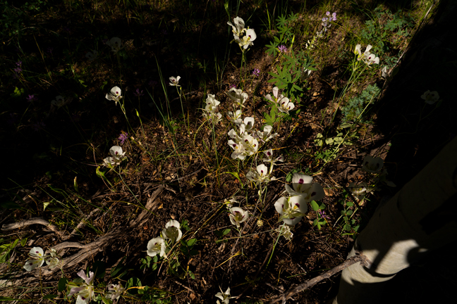
Smokey Mariposa, Calochortus Leichtlinii, Castle Rocks Trail, Castle Rocks State Park, Almo, ID
Castle Rocks State Park in Almo, Idaho is the antithesis of a national park. There is a lodge that you can reserve, but when you do, you are the only occupant. It’s actually a house that’s called a lodge and it has a full kitchen, multiple bedrooms, a dining room and multiple living areas. It only has one bathroom, no air conditioning and there’s a small noisy bunkhouse too close by, but it’s still a great and affordable place to stay in a lovely park that’s only five miles from the City of Rocks Natural Reserve. Rock climbers know these places well, but they are also great for hikers and those who want solitude.
On our 5.9 mile morning hike on Castle Rock Trail, that passes most of the major rock climbing sites within the park, we came across a single cluster of Smokey Mariposa, a species of flowering plant in the lily family.
©Rich Beckman
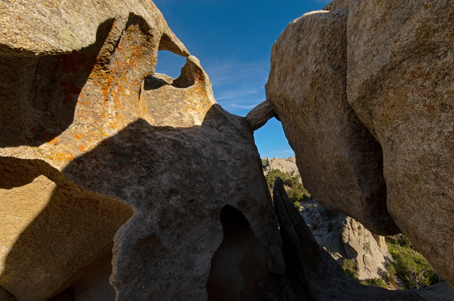
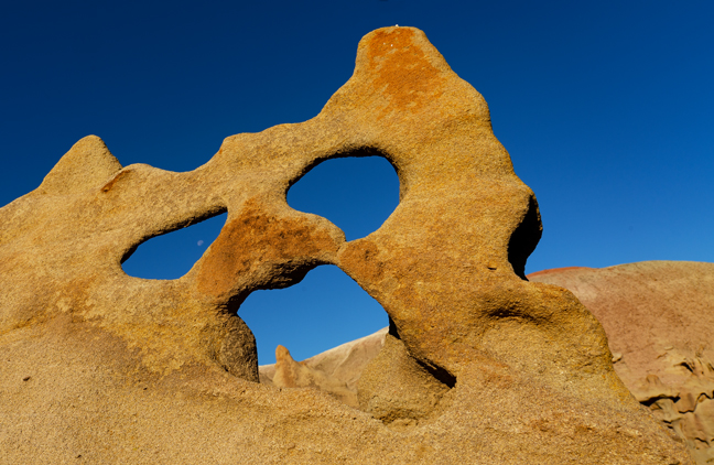
Leaning Arch (12S-275502-4661821, 8.7’x5.4’), City of Rocks Natural Reserve, Almo, Idaho
The City of Rocks Natural Reserve is known as one of the finest granite-face climbing sites anywhere with more than 700 developed climbing routes. It is one of numerous City of Rocks in Idaho. Others include Little City of Rocks Wilderness Study Area, Gooding City of Rocks West Wilderness Study Area and Gooding City of Rocks East Wilderness Study Area. These feature volcanic ash hoodoos as well as several natural arches, towers and mushroom caps.
There are numerous arches in the Reserve, mostly formed in narrow, elongated outcrops that were breached by cavernous weathering. Most are located in the central part of the Reserve where the weathering has been enhanced along a set of north-striking joints and the enlargement of the sidewall tafone.
©Rich Beckman
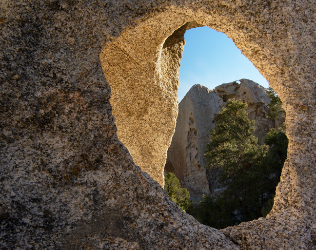
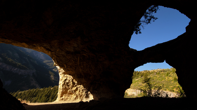
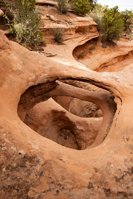
Eagle’s Eye Arch, SCR-33, City of Rocks Natural Reserve, Almo, Idaho
Eagle’s Eye Arch is not the opening in the foreground, but the one at the top of the formation in the background. (1/2)
©Rich Beckman
Eagle’s Eye Arch, SCR-33
Some arches are more challenging to visit than others. It was another cloudy morning, without much hope for interesting photographs, when two climbers walked by us near the base of the formation that featured Eagle’s Eye Arch high above. I decide to wait to see what would happen and after a while the first climber headed up the wall, setting carabiners in existing anchors and looping a rope through each. He was essentially free-climbing the wall up to the arch with the ease of a lizard scampering up a rock. (2/2)
©Rich Beckman
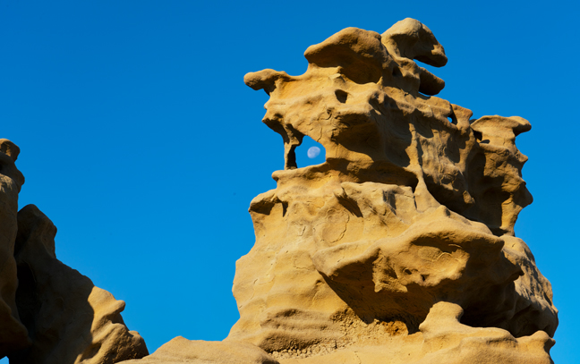
Flaming Rock Arch, SCR-4 (12T-0275642-4661768, 5.7'X3.5'), City of Rocks Natural Reserve, Almo, ID
©Rich Beckman
Part II
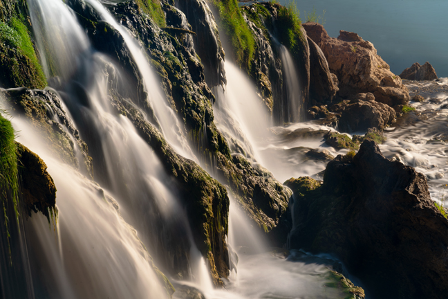
Fall Creek Falls, Swan Valley, Bonneville County, ID
I had an afternoon appointment in Idaho Falls, so after a brief stop at the Idaho Potato Museum in Blackfoot, ID, we made our way north to the big city. The next morning we headed out to find Fall Creek Falls. The falls, with an elevation of 5,280 feet and a 60-foot descent into the Snake River, is located in the Caribou-Targhee National Forest off U.S. Hwy 26 along NF-058 (or Snake River-Palisades Dam Road).
There is a path down to the base of the falls just past the small pull-off for the view from the top, but it was steep and muddy and even though there was a thin rope to assist in the descent, it seemed a bit sketchy to attempt carrying a tripod and cameras. The best way to reach the bottom of the falls is by boat or kayak from the nearby boat ramp.
©Rich Beckman
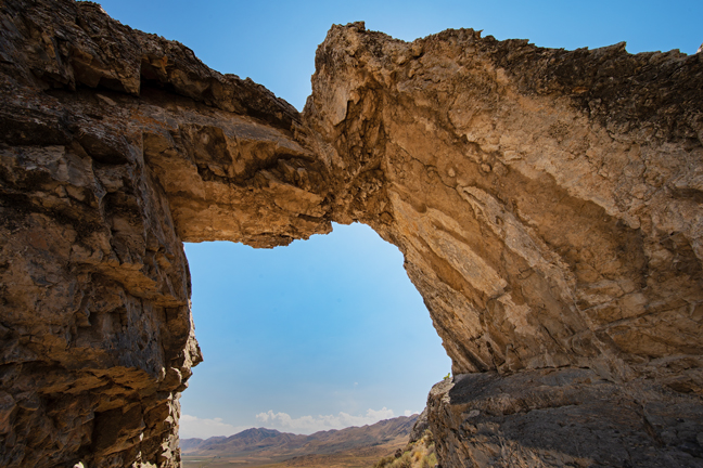
Chinese Arch (12S-374384-4610379, 12’x6’), Golden Spike National Historic Park, UT
After a couple of nights of rest and relaxation at the Riverside Hot Springs Inn in Lava Hot Spring, ID, we turned to the south to begin meandering our way back to Arizona. The Inn has what they call a Seniors Lodging and Dinner Special during the summer that includes a nightly $35 dinner credit, free breakfasts and free access to their onsite mineral hot springs. For some unknown reason, the one-street downtown also hosts an Olympic Swimming Complex and Indoor Aquatic Center where morning lap swims cost $2/day. At no extra cost, we stayed in the Presidential Suite, the same room where Teddy Roosevelt stayed during his visits. Not much has changed in the town since he visited.
Our first stop on our southward journey was Chinese Arch, which is not located in China, but within the Golden Spike National Historic Park, UT along the Promontory Trail Auto Tour Route. The placard at the site says, “More than likely, Chinese Arch was named in recognition of the presence and contribution made by the Chinese who worked on the transcontinental railroad. While the arch was created by forces of nature, today it stands as a memorial to the Chinese who worked for the Central Pacific Railroad. It is an embodiment of the strength and stamina demonstrated during their construction and subsequent maintenance of the transcontinental railroad.”
More than 1,200 Chinese workers died while building the railroad between 1865-1869. In February, 2006, the U.S. Board on Geographic Names approved changing the name of the arch from its original name, Chinaman’s Arch, to the current name, Chinese Arch.
©Rich Beckman
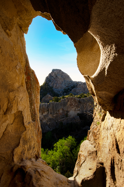
Wind Cave Arches (12S-440363-4623709), Logan Canyon, UT
The next morning, we set out to hike to the Wind Cave Arches. The arches are not in Wind Cave National Park, nor were they formed by the wind, but by underground water sources. They are in the Uinta-Wasatch-Cache National Forest about five miles up Logan Canyon near the Guinavah-Malibu campground. It’s a four-mile out and back hike with about 1,100 ft. of elevation gain, all on the way from the trailhead to the limestone caverns. We passed, or were passed by, about 15 hikers going and up and down the trail and they were all women or dogs.
©Rich Beckman
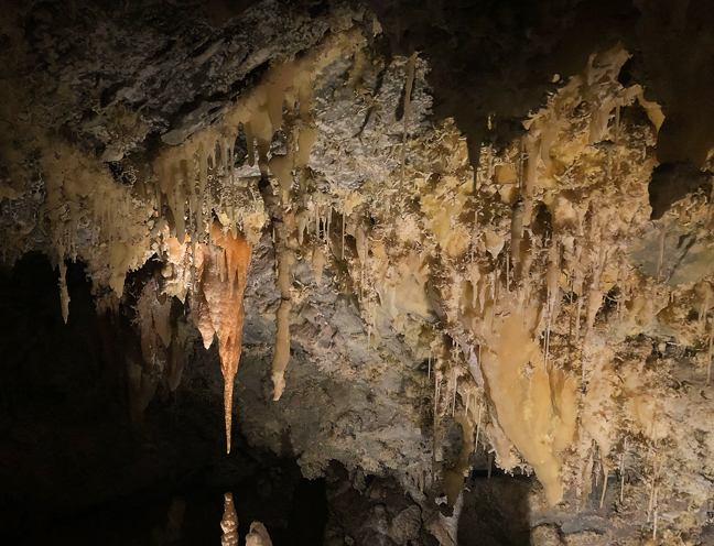
Tipanogos Cave National Monument, American Fork, UT
After climbing 1,100 feet on our two-mile sunrise climb to Wind Cave Arches, we embarked that afternoon on the 1,100 foot 1.5 mile climb to view the Timpanogos Cave System within Timpanogos Cave National Monument. Unlike our lovely shaded early morning hike, this hike required a reservation and ours was for a 2:45 p.m. departure, with afternoon highs in the mid-90s. Also, unlike our morning hike, this is a paved trail of endless switchbacks.
When you reach the cave entrance, you are met by a guide who leads a group of about 15 on a half-hour tour through the open parts of the three caves - Hansen, discovered in 1887 by Martin Hansen, a local settler; Timpanogos Cave discovered in 1915 and Middle Cave in 1921. The first cave tours were in 1922 and on October 14, 1922, President Warren G. Harding used the Antiquities Act of 1906 to set the caves as a National Monument. Once you enter the caves, the average temperature is 45 degrees.
After finishing the tour and hiking back down the mountain, we rewarded ourselves by heading directly to the Sauce Boss Southern Kitchen restaurant in nearby Draper, where we met Chef Julius, one of ten kids raised by his single grandmother in the projects on the south side of Chicago, not far from where I lived as a toddler. After two floured and fried pork chops topped with apple mash with large sides of candied yams and collard greens and too many refills of the sweetest iced tea west of the Mississippi, I was done for the day.
©Rich Beckman
Moonshine Arch (12S-623085-4490507, 80’x70’), Vernal, UT
Our next stop was Vernal, UT. where the big news in town was that they were accepting sealed bids for the refurbishing of the stucco for the T-Rex Dinosaur Statue located at 727 West Highway 40 (next to the Texaco). Vernal is known as the closest lodging for Dinosaur National Monument and for its natural gas production, but our first stop was Moonshine Arch.
You can supposedly drive to this arch, but it’s easier to just walk as it’s less than a mile from the parking area, which is a short drive from Vernal via Highway 191. There’s a large cavern adjacent to the arch that prevents sunlight from illuminating the arch until mid-morning and by then tourists begin to arrive.
©Rich Beckman
Fantasy Canyon (12T-636951-443541), Vernal, UT
We departed Vernal early the next morning for Fantasy Canyon. We had been to the Canyon before, but only when it was cloudy. Although the Canyon’s famous teapot formation was mysteriously toppled in 2008, there is still much to enjoy. Weathered sandstone formations rise from the clay beds in a variety of pinnacles, small arches, spires and knobs, all within a few acres in the small canyon that is surrounded by gas and oil wells forty miles south of Vernal. To reach the canyon, turn off your GPS and follow the small signs posted randomly throughout the maze of unpaved gas roads. Also, whne you do arrive, pay attention to the sign on the door of the outhouse that reads, “CAUTION, WATCH FOR PIGMY RATTLESNAKES.”
Tens of millions of years ago, the area was at the fringe of a vast subtropical lake – Lake Uinta – that stretched from the Wasatch Plateau to western Colorado. Rivers deposited sand, silt and clay shed from nearby mountains that solidified into layers of sandstone, mudstone and claystone. Differences in the rate of weathering and erosion ultimately shaped Fantasy Canyon. (1/2)
©Rich Beckman
Fantasy Canyon (12T-636951-443541)
Scholars believe that Edvard Munch’s inspiration for “The Scream” came from when he was out for a walk along a fjord overlooking Oslo, Norway in 1893. A better explanation is that he saw this formation in Fantasy Canyon. If he had been on the fantasy world of Gaia, he could have seen moons in both eyes.... After all, it is called Fantasy Canyon. (2/2)
©Rich Beckman
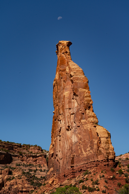
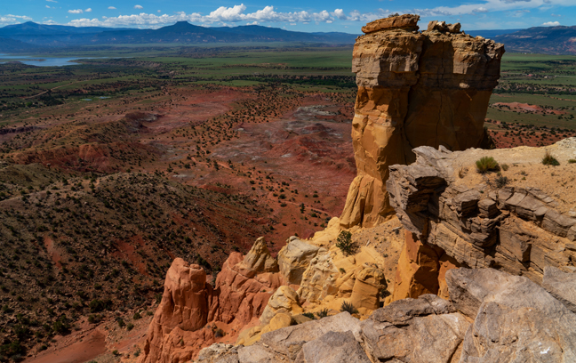
Moonset, Sentinel Spire, Colorado National Monument
We were joined by friends Marilyn and Joel for the first part of our week-long stay in Fruita, CO. We had previously hiked with them in Fruita, Utah, so it seemed appropriate that we would cross another Fruita of our list. Of course, there are also cities named Fruita in Oregon and Florida, so we are only half done.
Fruita, CO borders the Colorado National Monument and the McInnis Canyons National Conservation Area. The 31-square mile Monument, established in 1911, is an area of high desert, deep canyons and tall monoliths on the northeast side of the vast Colorado Plateau. The McInnis Canyons National Conservation Area includes Rattlesnake Canyon where the second largest concentration of natural arches outside of Utah’s Arches National Park exists.
In spite of daytime highs approaching 100 degrees, we hiked the Liberty Cap Trail to CO-214 arch and Otto’s Bathtub and the Monument Canyon Trail with Marilyn and Joel. Then we hiked to Tabeguache and Bench Trail Arches on our own and to Rattlesnake Canyon with Dave Kennedy, a friend from the Natural Arch and Bridge Society who lives in the area.
Sentinel Spire is a 200-foot freestanding Wingate Sandstone tower located in Wedding Canyon along the six-mile Monument Canyon Trail.
©Rich Beckman
Arch CO-214 (12S-697339-4324608, 5.5’ (largest opening)), Colorado National Monument
CO-214 is a waterfall natural bridge eroded through stacked bedding planes of Entrada sandstone (thanks Jay). The arches were known locally as Triple Bridge for several years, but now a fourth opening has developed. To get to the arches, follow the Liberty Cap Trail (starting at the west Liberty Cap Trailhead) for about a mile and turn to the right after about a mile at 12S-697133-4324921. The arches are situated on the canyon rim across from Suction Point (thanks Dave).
©Rich Beckman
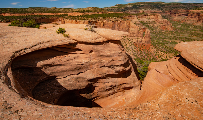
Otto’s Bathtub (12S-699279-4326838), Colorado National Monument
Otto’s Bathtub is named for John Otto, the man most responsible for the establishment of Colorado National Monument and its first superintendent in 1911. It is located on Monument Mesa in a cliff that caps the east rim of Monument Canyon. It is not known whether the basin was truly for bathing or for catching fresh water, but the chiseled out steps are well worn and no longer safe for descending into the basin. With the additional detour to CO-214, it was a 9.7 mile out-and-back hike and the tub was devoid of water, so there wasn’t even a soak along the way.
©Rich Beckman
Tabeguache Arch, also known as Wombat Arch (12S-718517-4316386, 35’x20’), Whitewater, CO
The trailhead is off CO141 just past Whitewater, CO. Turn right at the north end of the bridge over East Creek and park near the Jeep Tabeguache Trail sign. Apparently, construction of this section of the Jeep trail began in 2016 and is complete, but a locked gate prevented access. The Tabeguache Trail is a 141-mile-long trail that crosses western Colorado between Montrose and Grand Junction. It is open to hiking, as well as biking (in most places) and motorized use (in some places). The trail gets its name from the Tabeguache Band of Utes, who lived in the Grand Junction area until the Ute Removal Act of 1881 forced them off their ancestral land of 12,000 years.
There are two obvious trails to the top of the ridge from the parking area. When you get to the ridge line a bit more than a mile out, you can see the arch across the wash on the other side of the canyon. Finding a path to the arch is more of a mystery. There are supposedly faint trails to follow, but not finding them, we took a direct route, stumbling down one side of the canyon and scrambling up the other side. We got to the arch in nice morning light with only minor cuts and scrapes. Fortunately, we found a much easier return route a bit further down the canyon.
©Rich Beckman
Head of the Rattlesnake, Rattlesnake Canyon, McInnis Canyons National Conservation Area
Rattlesnake Canyon is thought to house 35 natural arches, second only to Arches National Park for the largest concentration of natural arches in the world. This is one of those places where the arches are fairly easy to walk to once you get there. Getting there is never easy and sometimes not possible. The 13-miles drive on Black Ridge Access Road just west of the Colorado National Monument requires high clearance and 4WD, and in good weather it takes about an hour. If it is raining or recently rained, the road is usually not passable.
There are two roads that parallel the southern boundary that are seasonally open to motorized travel. The Upper Road is open from April 15 - August 15, while the Lower Road is open from August 16 - February 15. Both roads are closed to motorized travel from February 15 - April 15. From Fruita it’s 11 miles from the Monument entrance station to the turn to "Glade Park Store," then .2 miles to the parking area and the start of the access road. You can also get to Rattlesnake Canyon from the Pollock Bench trial, but it’s a strenuous 15.5 miles out-and-back hike if you continue to the lower arches trail.
We met Dave Kennedy at the parking area at 6 a.m. and, knowing the road, he volunteered to drive. As predicted, we reached the trailhead at about 7 a.m. and descended into the canyon. The descent from the top of the mesa to the bench below is steep and rocky, but once you reach the lower arches trailhead, it is an easy walk. In the early morning, most of the arches are shaded, but in the summer, the afternoon temperatures reach 100 degrees, so there’s no ideal time to visit. Spring and fall are better options, but it is spectacular at any time.
©Rich Beckman
Centennial Arch (12S-686036-4335008, 120’x65’), Rattlesnake Canyon, McInnis Canyons National Conservation Area
©Rich Beckman
Trap Arch (12S-0686353-433459608, 32’x22’), Rattlesnake Canyon, McInnis Canyons National Conservation Area
©Rich Beckman
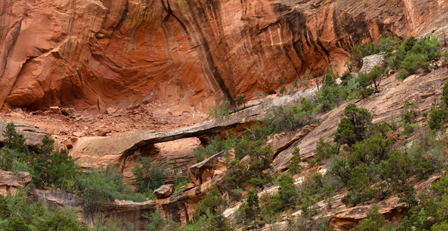
Bench Trail Arch (12S-700-483-4326949, 20’), Rattlesnake Canyon, McInnis Canyons National Conservation Area
After many challenging hikes in hot weather, we decided on an easier hike for our final day. We started at the east Liberty Cap Trailhead in Redlands, CO and followed it uphill for about a mile until we reached Bench Trail. We then followed Bench Trail in search of Bench Trail Arch. We knew that it spanned the lower part of a large alcove in a nearby side canyon and the GPS showed it be about .9 miles down the trail. Actually, it’s a backcountry trail that wasn’t clearly marked on the GPS, so what we really knew was that it was about .9 miles to the northwest of our location. The GPS forgot to mention the mountain that we would have to circumvent to get to the arch or that the arch was high off the trail and required significant bushwhacking to reach.
After a bit more than seven miles we returned to the trailhead. That evening, we had a lovely dinner at Dave and Judy Kennedy’s house in Glade Park, admired their lovely gardens and enjoyed a beautiful sunset on our drive home through the Monument.
©Rich Beckman
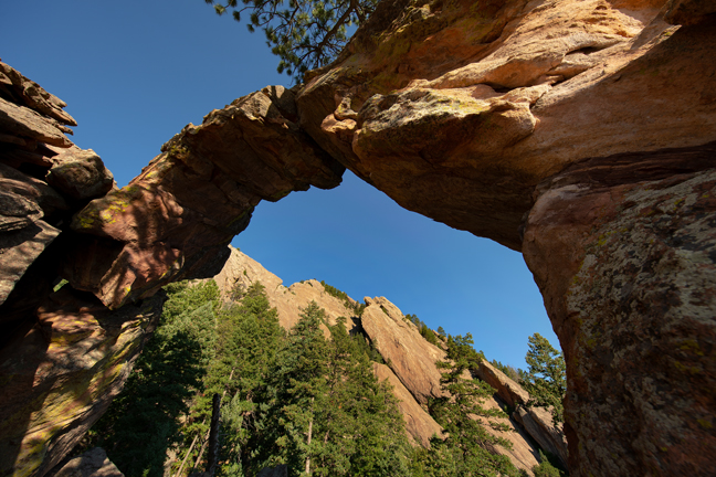
Royal Arch (13S-475169-4425793, 20’x20’), Boulder, CO
We departed the next morning for Boulder, where we would climb to Royal Arch and then have lunch with Ross Taylor.
The trailhead to Royal Arch is reached from Chautauqua Park, an historic landmark at the foot of the Flatiron Mountains, dating back to when the city of Boulder began preserving wilderness more than 100 years ago. The trail was under construction and closed M-Th 8 a.m. to 4 p.m. We arrived at sunrise and were well past the closure on our way back down before the work crews arrived. Currently, the upper portion of the trail is a scramble, but the most difficult climbs will be stepped once construction is finished. There’s a 1,400 elevation gain on the 1.5 mile climb to reach the arch.
I’ve known Ross for 30 years, since he was one of my photojournalism students and lab assistants at UNC-CH. Our paths rarely cross, so it was a wonderful reunion.
After lunch, we headed down to Denver to have dinner with Katie and Greg. Cynny and Katy have been friends since college. Then we headed to Littleton to spend a few days with Bob and Carol that included a couple of White Sox games against the Rockies. Bob retired about the same time I did after more than 45 years in journalism and education, outlasting me by three years.
After a wonderful visit with Bob and Carol and another inept performance by the White Sox, we headed to Del Norte, CO with planned stops at Great Sand Dunes National Park and Preserve, La Ventana Arch and Zapata Falls. Heavy storms prevented us from visiting any of those locations so we continued on the next day to Las Vegas, NM for an overnight stay with Carol, another of Cynny’s long-time friends.
From there we continued on to Taos for no particular reason other than to explore the town and from there to Abiquiu where the weather finally cleared for our visit to Ghost Ranch, the home and studio of Georgia O'Keeffe, as well as the subject of many of her paintings.
©Rich Beckman
Chimney Rock, Ghost Ranch, Abiquiu, NM
In the morning, we hiked the Chimney Rock Trail. It’s about a three-mile hike with 600-feet of elevation gain that provides views across to Pedernal and the Piedra Lumbre basin, the heart of Georgia O'Keefe country. The hike circles around Chimney Rock climbing up to the top of the mesa adjacent to the formation.
©Rich Beckman
View of El Monte Rojo from Ghost Ranch, Abiquiu, NM
That afternoon, after a picnic lunch on the museum patio, we took the Ranch’s Georgia O’Keeffe Landscape Tour. The narrated tour takes you to sites that O’Keeffe painted while living at Ghost Ranch. Along the route, the guide shares reproductions of O’Keeffe paintings at the actual sites. The trees she painted have grown, but little else has changed, so it’s an interesting way to share her art and surrounding landscapes.
©Rich Beckman
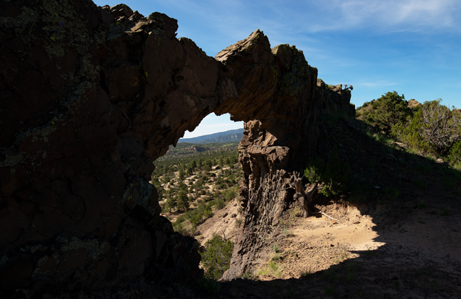
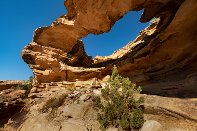
Window Rock NM-445 (13S-0390395-3998650, 30’x15’), Santa Fe National Forest, NM
After spending a relaxing day at Ghost Ranch, we headed out the next morning at sunrise for Window Rock. There are at least 20 catalogued arches named Window Rock. This one requires a 3.5 mile hike in Arroyo de las Lemitas in the Santa Fe National Forest to reach the cliff and then a half mile climb to the arch. The last quarter mile follows a narrow, steep social trail that climbs to the top of the ridge and then to the arch that sits on the edge of the ridge. You can’t walk through the arch as there is a steep drop-off. The trail takes you around the “back” of the arch that is backlit in the morning.
You can shorten the hike a bit by following the ATV tracks rather than staying in the arroyo the entire hike.
©Rich Beckman
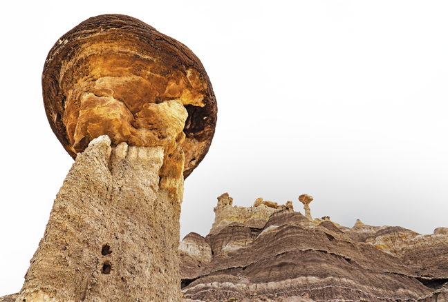
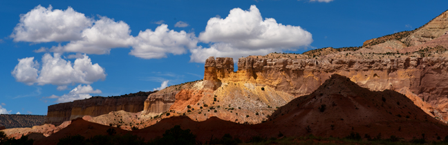
Lybrook Fossil Area (Badlands), Counselor, NM
This is the southernmost of the named New Mexico Badlands, located about 20 miles northeast of Chaco Culture National Historic Park. The closest hotels are in Farmington more than an hour to the north, but we rented a lovely Navajo Hogan on a Christian Mission Campus near Counselor, NM (VRBO) Property ID: 2335000) that is less than 10 miles from the turn onto CR7900. Since it is BLM land, you could also camp right in the Badlands, although there are no facilities. The unnamed oil field roads into the center of the area require high clearance 4WD.
We were guided by Peter Jamieson, a Natural Arch and Bridge colleague, who drove down from Durango to meet us. Thanks Peter! It was a cloudy morning with little, if any, sunlight, so it was less than ideal for photography, but nice for hiking and learning the area. The area is characterized by rolling mounds of mud and siltstones with interdispersed sandstones. The hoodoos are massive in comparison to those in the Bisti, although the Bisti and De-Na-Zin Badlands have a greater geologic variety. (If you are visiting the De-Na-Zin area, do not attempt to access the parking area from the east off of NM371. County Road 7023 is closed from the east because much of the road has been washed away. It was possible (and fun) with a high clearance 4WD vehicle, but there are a few sections that were dangerous and it will likely get worse as the monsoon rains continue. In some sections there are steep drops on either side of what is left of the road and a few steep drops and rises into sandy ditches that required 4WD low.)
©Rich Beckman
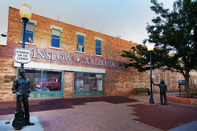
Standing on a Corner in Winslow, AZ (West 2nd Ave. and Kinsey Ave.)
We made one more stop before arriving back home in Tucson. Because we live in Arizona and because Winslow, AZ is halfway between the Badlands and home and because we enjoy Jackson Browne and The Eagles, we scheduled a stop so that we could “Take It Easy” in Winslow, AZ.
“Well, I’m standing on a corner in Winslow, AZ
And such a fine sight to see
It’s a girl, my Lord, in a flatbed Ford
Slowin’ down to look at me”
During 1960’s Winslow was the largest town in northern Arizona. It was headquarters for the Santa Fe Railway and home to the massive Hubble Trading Post warehouse, part of a vast trading empire of Native American wares and home La Posada, the finest Harvey Hotel in the Southwest, which opened in 1929 and cost $40 million in today’s dollars.
La Posada shut its doors in 1957 and Route 66 was decommissioned in 1985 and replaced by I-40 that bypassed Winslow. After it closed, the hotel languished for years as the Santa Fe Railway offices. It was slated for demolition when Allan Affeldt convinced the railway to sell it to him. It cost more than $12 million to renovate and today is once again a classic grand hotel. Rooms are named for famous guests that included Albert Einstein, Amelia Earhart, Betty Grable, Clark Gable, Jimmy Stewart, John Wayne, Presidents Franklin Roosevelt and Harry Truman, Shirley Temple and Will Rogers amongst a long list. We stayed in the Roy Rogers Room.
The town nearly disappeared after the completion of I-40. One by one the decades-old downtown shops began to close. For the next twenty years, Winslow faded into obscurity.
Then, as the legend goes, Jackson Browne had car trouble on the way to or from Sedona and spent a day in Winslow. He wrote most of the song, but Glenn Frey contributed the lyric, “It’s a girl, my lord, in a flatbed Ford, slowin’ down to take a look at me.” Browne said, “I had dug the fact that all these women in Arizona were driving trucks. It appealed to me.”
On May 29th, 1997, the Standin’ on the Corner Foundation took the first steps to develop a park at the heart of downtown Winslow that would commemorate the song, the Eagles first single, “Take it Easy.” The project resulted in the Standin’ on the Corner Park that was dedicated on September 10th, 1999. It originally included the two-story, Trompe-l’œil style mural by John Pugh and a life-sized bronze statue by Ron Adamson named “Easy.”
On October 18, 2004, there was a fire at the Standin' on the Corner Park. While the face of the building and the actual corner survived, the rest of the building burned down. The remaining wall had to be stabilized and the mural, painted on panels attached to the wall, had to be re-done. Between insurance claims, building permits and restoration, the park was surrounded by a chain-link fence for years.
When Glenn Frey, a founding member of the Eagles, died on January 18th, 2016, the Standin’ on The Corner Foundation commissioned a new statue to be installed on The Corner next to “Easy” in his memory.
This year’s Standing on the Corner Festival will be held on September 23 and 24, 2022.
©Rich Beckman