The Covid Years, 2020-22
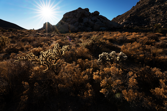
When possible, we stayed close to home during the worst of the Covid years (to date). Of course, when you live in southern Arizona, southern Nevada, southwest New Mexico and all of Arizona are within a day’s drive, so it is not a terrible hardship. All of the places we visited will require much more exploration as it becomes easier to travel and lodge. Many, but not all, require a high-clearance 4WD vehicle, so Rubi (our Jeep) was a busy girl. In keeping with Covid guidelines, most of these places are isolated and devoid of crowds (or any other people at all) and were selected for that reason.
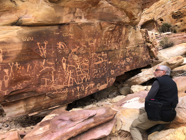
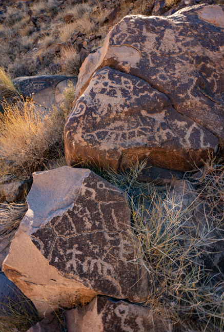
It can be difficult to keep up with world events in such locations, but fortunately you can still find news along the route. Here, I take a break to catch up on the local news at Newspaper Rock in Gold Butte National Monument. The Monument was designated by President Obama on December 28, 2016, the same day as the designation of Bears Ears National Monument. The petroglyphs were carved about 2,000 years ago, by the people from the Archaic, Anasazi, Fremont, Navajo, Anglo and Pueblo cultures. In Navajo, the rock is called Tse' Hone (a rock that tells a story). There are more than 650 petroglyphs on Newspaper Rock, so there was a lot of news to take in. There are numerous Newspaper Rocks throughout the Southwest, so a lot to learn along the trail.
©Cynny Scott
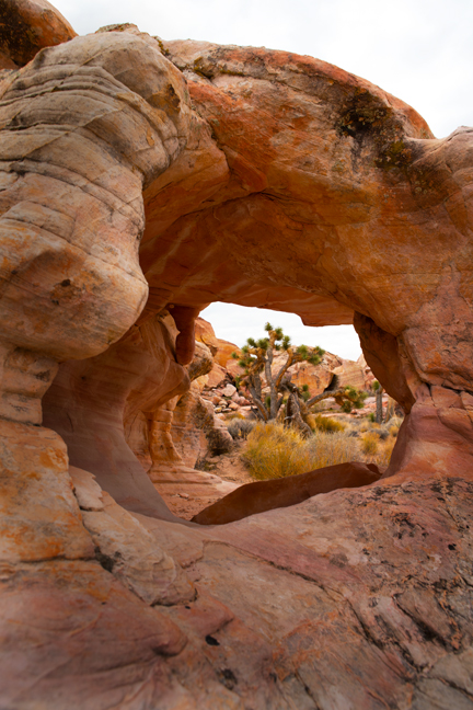
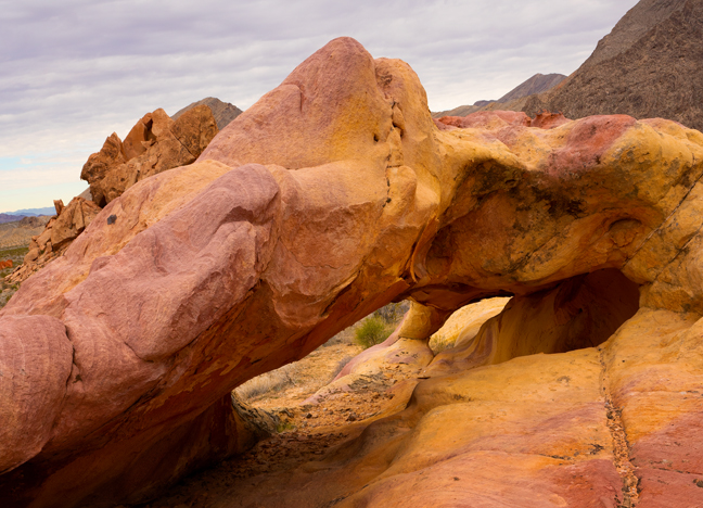
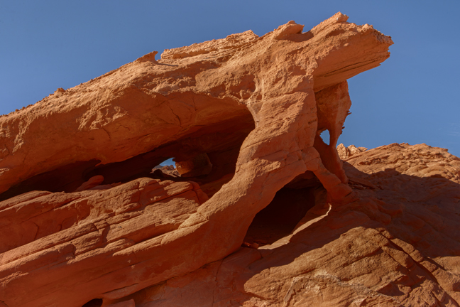
Unnamed Arch, Whitney Pocket, Gold Butte National Monument, Nevada
Gold Butte National Monument covers nearly 300,000 acres of remote desert landscape in southeastern Nevada. The Gold Butte gold rush began in 1906, bringing more than 2,000 miners to the area. Most miners passed by Whitney Pocket on their way to try and strike it rich. The gold rush was short lived, ending in 1909.
George “Luke” Whitney came to the Gold Butte area in 1910. He and his family purchased and developed the Aravada Ranch east of Whitney Pocket. The Whitneys spent summers at the ranch, and soon began hosting guests. The ranch became an oasis and is still open today as a camping destination. Whitney Pocket is named for Luke.
The CCC came to Whitney Pocket to establish a camp and build a cistern as well as other improvement projects in the Gold Butte area. It is their mark on the pocket that is most prominent today. The cistern they built is still in place, an immense block and concrete structure complete with stairs to climb up and down both sides. They also walled off several alcoves for storage, with some of the walls still in place.
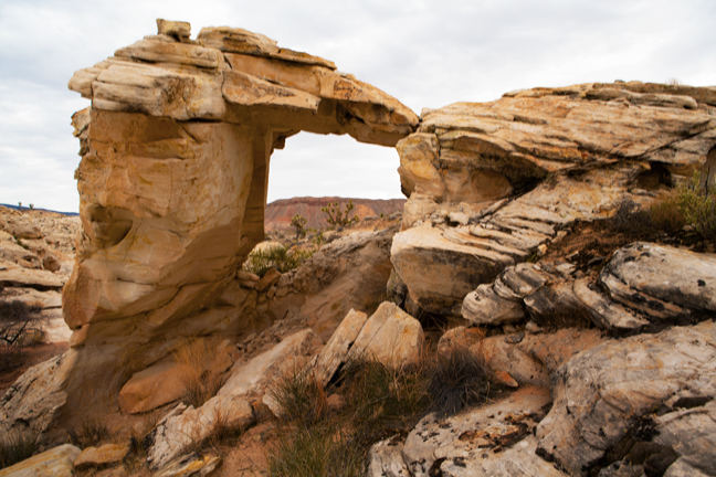
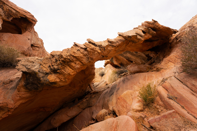
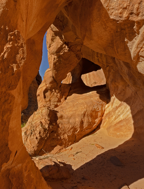
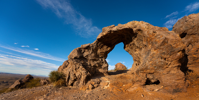
The view of Joshua Trees is better through this small unnamed arch (11S-751938-4044176) than through the larger named Joshua Tree Arch, which is further up the trail. This arch is adjacent to Calvin’s Rock (named after Calvin Meyers, former Chairman of the Moapa Band of Paiutes and environmental activist), near the trailhead to the Falling Man petroglyph in Gold Butte National Monument off of Black Butte Road.
©Rich Beckman
Joshua Tree Arch (11S-751715-4043139, 15’x10’), Gold Butte National Monument, Nevada
This arch is near the 21 Goats petroglyph panel in the Whitney Pocket area of Gold Butte National Monument.
©Rich Beckman
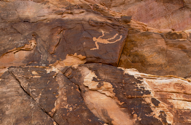
Falling Man Petroglyph, Gold Butte National Monument, Nevada
The history of this uncommon petroglyph is unknown. Western Anasazi inhabited Gold Butte several thousand years ago, and more recently Southern Paiute Indians traveled through the area. The petroglyph may date from 700 to several thousand years ago.
©Rich Beckman
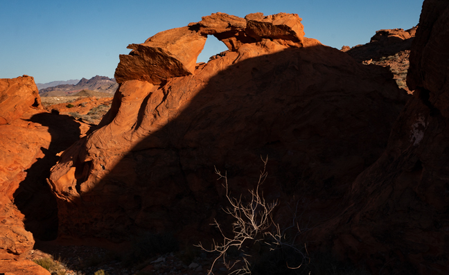
Purple Triple Arch (11S-755806-4045367), Gold Butte National Monument, Nevada
©Rich Beckman
Long Pockets Arch in Whitney Pocket (11S-755891-4045654), Gold Butte National Monument, Nevada
©Rich Beckman
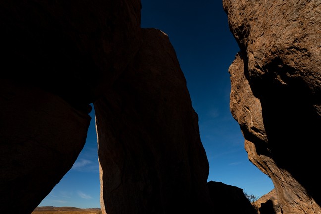
Unnamed Arch (11S-756542-4046064), Whitney Pocket, Gold Butte National Monument, Nevada
©Rich Beckman
Unnamed Arch (11S-708863-4030684), Color Rock Quarry, Buffington Pockets, Nevada
Buffington Pockets is an area of 170 million-year-old striped Aztec sandstone about 50 miles east of Las Vegas, Nevada. It was formed when the Pacific Plate collided with North America 70 to 160 million years ago. The Dolostone mountains of the Pacific Plate thrust over the younger sandstone of what is now southern Nevada. Color Rock Quarry, accessed via Color Rock Road, contains many small arches.
©Rich Beckman
Unnamed Arch (I call this Sea Turtle Arch), Lower Bowl of Fire, Callville Wash, Nevada
About 30 miles east of Las Vegas at mile marker 16 (11S-707939-4008207), off Northshore Road is the left turn into Callville Wash, a rocky 4WD road that leads to the trailheads for the Lower and Upper Bowls of Fire. The Lower Bowl of Fire is within the Lake Mead National Recreation Area whereas the Upper Bowl of Fire is mostly within the Muddy Mountains Wilderness Area. Both areas feature numerous natural arches. The lower area is mostly comprised of red Aztec sandstone, whereas the colors in the upper bowl are a mix of red, purple, pink and white.
From the turn, drive two miles up Callville Wash to the first trailhead for the Lower BOF (11S-709977- 4010427). Drive another 0.75 miles up the wash to the second trailhead for the Lower BOF (11S-710892-4011149). Travel 5.5 miles to the parking area for the Upper BOF (11S-712598-4014223).
©Rich Beckman
Unnamed Arch, Upper Bowl of Fire, Callville Wash, Nevada
About 30 miles east of Las Vegas at mile marker 16 (11S-707939-4008207), off Northshore Road is the left turn into Callville Wash, a rocky 4WD road that leads to the trailheads for the Lower and Upper Bowls of Fire. The Lower Bowl of Fire is within the Lake Mead National Recreation Area whereas the Upper Bowl of Fire is mostly within the Muddy Mountains Wilderness Area. Both areas feature numerous natural arches. The lower area is mostly comprised of red Aztec sandstone, whereas the colors in the upper bowl are a mix of red, purple, pink and white.
From the turn, drive two miles up Callville Wash to the first trailhead for the Lower BOF (11S-709977- 4010427). Drive another 0.75 miles up the wash to the second trailhead for the Lower BOF (11S-710892-4011149). Travel 5.5 miles to the parking area for the Upper BOF (11S-712598-4014223).
©Rich Beckman
Unnamed Arch, Upper Bowl of Fire
About 30 miles east of Las Vegas at mile marker 16, off Northshore Road (11S-707939-4008207) is the left turn for Callville Wash, a rocky 4WD road that leads to the trailheads for the Lower and Upper Bowls of Fire. The Lower Bowl of Fire is within the Lake Mead National Recreation Area whereas the Upper Bowl of Fire is mostly within the Muddy Mountains Wilderness Area. Both areas feature numerous natural arches. The lower area is mostly comprised of red Aztec sandstone, whereas the colors in the upper bowl range are a mix of red, purple, pink and white.
From the turn, drive two miles up Callville Wash to the first trailhead for the lower BOF (11S-709977- 4010427). Drive another 0.75 miles up the wash to the second trailhead for the lower BOF (11S-710892-4011149). Travel 5.5 miles to the parking area for the upper BOF (11S-712598-4014223).
©Rich Beckman
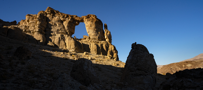
Liberty Bell Arch (11S-705173-3983562, 30’x25’), Lake Mead National Recreation Area, Willow Beach, Arizona
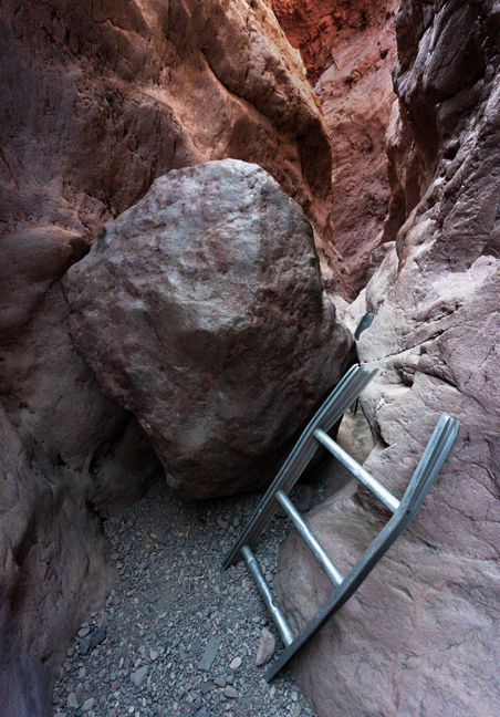
The trailhead for this 5.1 mile hike is located along Highway 93, four miles south of Hoover Dam in the Lake Mead National Recreation Area, about 45 minutes southeast of Las Vegas. The White Rock Canyon trail leads to the arch and then continues another half mile past the arch to a plateau overlooking the Colorado River.
Most people in the parking area are there to take the trail to Arizona Hot Springs rather than the side trail to the arch. That hike includes a 25-30 foot ladder climb down to the hot spring. The ladder occasionally gets washed away in a flood and the sign at the trailhead informing you if there is or isn’t a ladder is often not accurate. Even if the ladder is there, it ends just below the slick ledge that has a steady flow of water, so climbing down or back out requires you to use the attached rope to get yourself over the edge, assuming the rope is still there.
©Rich Beckman
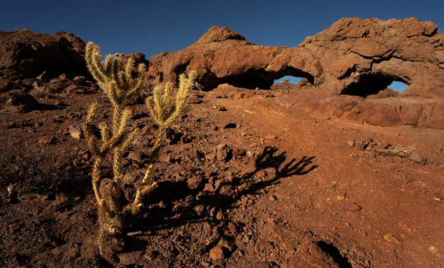
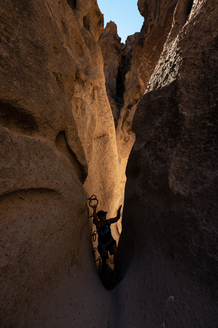
Crack in the Mountain Trail, Lake Havasu City, Nevada
SARA (Special Activities and Recreation Area) Park is an 1100-acre regional park and also home to the Havasu 95 Speedway. The five-mile Crack in the Mountain Trail (trailhead: 11S-751295-3814749) known by locals as "SARA's Crack," primarily follows a natural wash down to Lake Havasu, but passes through one of the most famous slot canyons on the Lower Colorado. It ends at a scenic cove on the lake beside Balance Rock. There are various natural obstacles and rather bizarre aids within the slot canyon, such as this rickety sawed-off ladder on one side of this choke rock.
©Rich Beckman
Along the trail to Murl Emery Bridge (11S-697274-3955840, 25’x15’), located one mile north of Nelson, NV on Techatticup Wash, are these smaller unnamed arches.
©Rich Beckman
Petroglyph Canyon Trail, Sloan National Conservation Area, Nevada
In November 2002, Congress designated the 48,438 acre Sloan Canyon National Conservation Area, The 14,763 acre volcanic North McCullough Wilderness lies entirely within the Sloan Canyon NCA, only a few miles from Las Vegas and the City of Henderson. The Petroglyph Canyon Trail follows a ravine through the western section of the McCulloch Range to one of the most important archaeological sites in Nevada with more than 1,700 petroglyphs spread across more than 300 panels. The petroglyphs, which cover several thousands of years of history, are concentrated in an area about 1.8 miles south of the trailhead and can also be accessed via the Cowboy Trail or Hidden Valley Trail.
©Rich Beckman
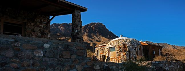
Mitchell Caverns Homestead, Mitchell Caverns Natural Preserve, Mojave National Preserve, California
The Mitchell Caverns Natural Preserve and the Providence Mountains State Recreation Area, managed by the California Department of Parks and Recreations, are located within Mojave National Preserve. Although the Preserve is open every day, the Recreation and Preserve areas only open on weekends and holiday Mondays. The actual limestone caverns are only open via paid guided tours. The Mitchells moved to the area in 1934 and tried to run the caves as a desert resort until the mid-50s. They sold the area to the State in 1954. Their former home is now the tour and visitor center. Keepers of the Caves, a fascinating history of their adventures is available from the Mojave Desert Heritage and Cultural Association (https://mdhca.org).
Mojave National Preserve was established October 31, 1994 with the passage of the California Desert Protection Act. Containing more than 1.5 million acres, it is the third largest unit within the National Park System (outside of Alaska). The Preserve encloses the Providence Mountains State Recreation Area and Mitchell Caverns Natural Preserve. The ghost town of Kelso is also within the Preserve, with the defunct railway depot serving as a Visitor Center, although it is currently closed and not expected to re-open before Spring 2023.
The town of Goffs, CA, situated along the original Route 66, on the southeast corner of the Preserve was created in 1883 as a mainline stop on the Sante Fe Railroad. In the early 1900s members of the Sante Fe Railroad Company moved to Goffs and in 1914 a schoolhouse was built and classes begun. Goffs continued to prosper as a main stop until 1931 when the road was realigned and Goffs slowly become a ghost town. In 1937, the schoolhouse ceased operation and fell into disrepair. Soon thereafter the building was repurposed as a canteen for the Desert Training Center, the largest Army training facility in the country during World War II.
Today, it is a museum owned and managed by the Mojave Desert Heritage and Cultural Association and the epicenter for the Mojave Road and East Mojave Heritage Trail explorations. There are multiple working mills, gyrators and crushers from the 1800s and you can even sign up to take a certification course to become a genuine millwright. The site is also home to the Dennis Casebier library, the most extensive historical archive on all things and people related to the Mojave Desert.
The unmaintained Mojave Road is an east-west route, roughly 150 miles long, that traverses the desert between the Colorado River and the Mojave River near the neighborhood of Wilmington in the Harbor region Los Angeles. Most of the Mojave Road is within the boundaries of the Mojave National Preserve. The road enters the park near Piute Spring on the east side and on Soda Dry Lake near Zzyzx on the west. It was first used by Indigenous people to transport goods from the southwest to trade with the Chumash and other coastal tribes and later by American settlers on their westward expansion. Military forts were established along the route to protect key water sources and provide assistance for travelers.
The Mojave Desert Heritage and Cultural Association (https://mdhca.org) is currently struggling financially to survive, so your membership would be welcome.
©Rich Beckman
Quail Spring Basin Trail, Mojave National Preserve, California
The Basin is located within the southern area of the preserve about eight miles south of the popular Kelso Dunes. The 6.5 mile lollipop trail begins with a 1.8 mile steady sandy (annoying) climb to the pass into the Basin which features Mojave Yucca and juniper mixed among eroded granite outcroppings and boulders.
©Rich Beckman
Hole-in-the-Wall Rings Trail, Mojave National Preserve, California
The trailhead for the Hole-in-the-Wall Rings Trail is accessed from the Hole-in-the-Wall Campground, 20 miles north of I-40. Take the Essex Road exit to Black Canyon Road (both paved). As the 1.5 mile loop trail ascends Banshee Canyon, two successive short climbs feature the namesake rings that serve as hand and footholds.
©Rich Beckman
Teutonia Peak Trail, Mojave National Preserve, California
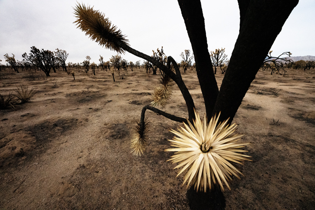
In August of 2020, a lightning strike ignited dried grasses on Cima Dome, the most symmetrical natural dome feature in the United States. By the time it was fully contained, the Dome Fire had scorched 43,273 acres of Joshua tree woodland including most of the Teutonia Peak trail, which prior to the fire was the world’s largest and densest Joshua tree forest. It destroyed more than 1.3 million Joshua Trees. The trailhead is located just off Cima Road, that stretches 17 miles from the Cima Road exit on Interstate 15 south to Cima. The signed trailhead is on the west side of the road about 11 miles from I-15.
©Rich Beckman
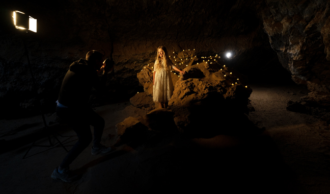
Lava Tube, Mojave National Preserve, California
If you visit enough isolated places, you will eventually happen upon moments of weirdness that you will struggle to believe. Such was the case on a November day when visiting the Lava Tube in Mojave National Preserve where a nine-year-old girl in a long white gown surrounded by her doting mother and a camera crew was singing Mary, Did You Know? for a YouTube video. They had lit the interior and provided a background of dozens of small candles and musical accompaniment. All were unmasked during the height of Covid and they didn’t have the required commercial photography permits. A bit different than my childhood.
©Rich Beckman
City of Rocks Arch (13S-220821-3610305, 12’x10’), Faywood, NM
This arch is in the New Mexico City of Rocks State Park campground near site #25. The park is 29 miles NNW of Deming, NM. This is not the City of Rocks National Reserve that is located in Almo, ID nor the Little City of Rocks outside Gooding, ID nor the City of Rocks just west of the Little City of Rocks. Got it?
©Rich Beckman
Dona Anna Arch (13S-327660-3592065, 12’ x 6’), Dona Anna, New Mexico
It’s easy to get to the area from the Dona Ana exit off I-25, just north of Las Cruces, NM or via US-70 E. But shortly thereafter, once you reach the intersection of county roads DO53 and DO54, you encounter numerous crisscrossing ATV trails, most of which are nothing more than steep talus slopes. Some or all of these lead to the arch, but there are no maps or signage.
We parked a quarter mile past the intersection and hiked a couple of miles to the arch, on and off the trails. The footing is better going cross-country as the trails are pretty torn up from the ATV traffic. There is also a second arch along the route (Dona Ana Arch 2). Just beyond the Dona Ana Arch there is a grave marker that reads “In Memory of ROSS, Keep Wheelin’, 1964-2014” so perhaps our decision to hike, rather than drive, was justified.
©Rich Beckman
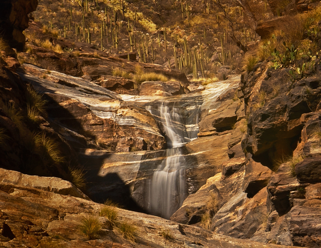
Seven Falls, Sabino Canyon Recreation Center, Tucson, Arizona
This is one of the most popular and crowded trails in Tucson and one of the few that contains a significant seasonal waterfall. When flowing, the waterfall in front of a backdrop of saguaros is stunning. There are seven water crossings before you reach the falls at the turn-around point (4.15 miles), so depending on the snowmelt and water level, these can be fun rock hops or more strenuous wet crossings. The falls are in a deep canyon so are only lit in mid-day. During our visit there were dozens of people sunning, swimming and climbing around the various cascades brandishing their selfie sticks.
There is a pay shuttle that will shorten the hike.
©Rich Beckman
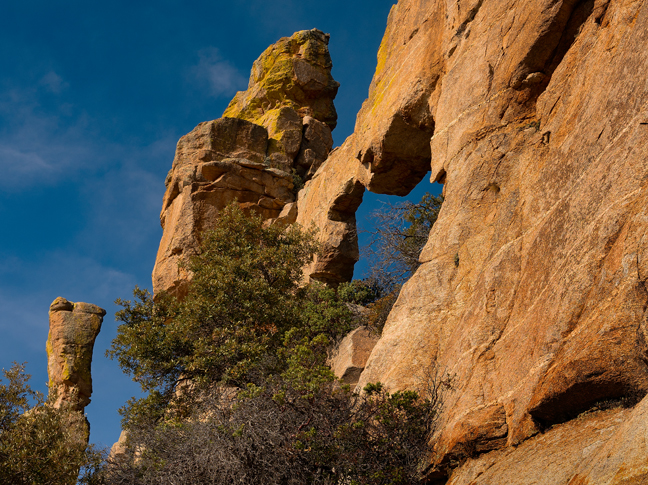
Rocky Arch (12S-528021-3582288, 18’x10’), Mt. Lemmon, Coronado National Forest, Tucson, Arizona
This is our neighborhood arch, just across town and right along the road. When you come to visit, this is one of the stops on the tour.
Coronado National Forest includes an area of about 1.78 million acres in southeastern Arizona and southwestern New Mexico. The Santa Catalina Ranger District features Mount Lemmon, the highest peak in the Santa Catalinas. Catalina Highway Scenic Drive in east Tucson is the only paved road that reaches the crest of Mt. Lemmon (9,171’). The road starts in the lower Sonoran vegetative zone and climbs to the high forests of the Canadian zone, all within 27 miles. At the peak is the Mount Lemmon Ski Valley, the southernmost ski destination in the continental U.S. Work on the highway began in 1933 and was finished 17 years later. Much of the labor was by prisoners from a federal facility established at the base of the mountain for the specific purpose of building the road.
©Rich Beckman