We had an impressive monsoon season in Tucson this year with more than a foot of rain, the third wettest in more than 100 years and July 2021 was Tucson’s wettest month on record. The desert turned lovely shades of green and the ocotillo enjoyed a second bloom, but August and September temperatures soon returned to highs above 100º and we returned to cooler climes.
The first stop on our agenda was the Natural Arch and Bridge Society Rally in Capitol Reef National Park (and surroundings) and a few days in and around Escalante, Utah with childhood friends Marilyn and Joel. It was our first rally in two years after three Covid cancellations and as editor, designer and photographer for SPAN, their quarterly magazine, I attend whenever possible. More importantly, it is a great group of welcoming folks who are at least as crazy as we are in the pursuit of isolated hikes and stunning landscapes.
Next came a long-overdue trip to D.C. to visit daughter Emmie with side trips to Vermont and NYC. We have both friends and family in NYC (my birthplace) so every meal is a reunion. We went to Vermont because we’ve lived the past 14 years in places where leaves don’t change colors and what streams we have dried up months ago.
Vermont is a breath of fresh air. Many of the old family-owned inns I knew decades ago are gone, but even with the roads filled with leaf-peepers, there are plenty of places to find solitude. Local artisans abound, there’s a variety of local root beers and Heddy Topper is still best when drunk from the can. The highlight of every lawn is a brightly-colored Adirondack chair and people still wait patiently in line for an hour just to enjoy an ice cream cone at the Ben and Jerry’s Factory Scoop Shop. I had a scoop of Cherry Garcia on a waffle cone, because I always have a scoop of Cherry Garcia on a waffle cone. I was never a Deadhead, but what’s better than Cherry Ice Cream with Cherries and Fudge Flakes? Nothing.
We’re not city folk, but I always enjoy my time in D.C. and tolerate my time in NYC because I love our friends who live there, but it gets more difficult with every visit. I expect the closet-sized over-priced hotel rooms and over-priced over-rated restaurants, but the city is filthy and the combined stench of garbage piled on the Midtown sidewalks, smelly sewers and ever-present marijuana smoke permeate every street. Combined with the plethora of loud, disorderly and often mentally ill loitering drunks, it’s no longer a pleasant place to walk or visit. It’s even worse now that Covid has forced sidewalk dining cubicles. Perhaps I am just getting old and losing what little patience I had for such things. I do recommend walking the Hudson River Greenway that now stretches 4.5 miles from Central Park to Battery City Park. It, like the other city parks, provides an escape from the reality of what the city has become.
On a positive note, you can’t enter a restaurant or theater in NYC without showing your Covid immunization card and ID.
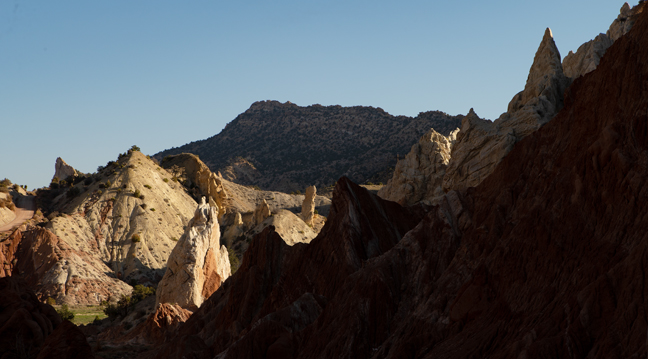
Cottonwood Canyon Road, Grand Staircase-Escalante National Monument
After picking up Joel and Marilyn at Sky Harbor Airport in Phoenix and spending a night in Page, AZ, we headed north out of Big Water, UT on Cottonwood Canyon Road, a 47-mile unpaved route through Grand Staircase Escalante National Monument, toward Capitol Reef National Park for the Fall 2021 Natural Arch and Bridge Rally. The forecast was for rain which would make the road impassable, so we skipped a planned morning hike to stay ahead of the weather.
©Rich Beckman
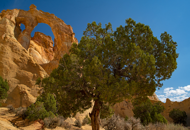
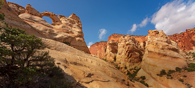
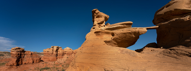
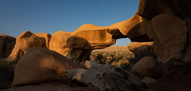
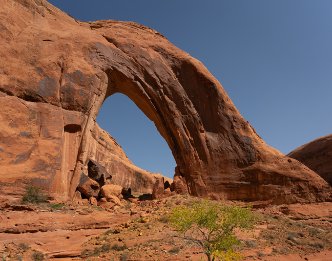
Grosvenor Arch (12S-426455-4145857, Span: 55 feet, Height: 85 feet (largest opening)). Cottonwood Canyon Road, Grand Staircase-Escalante National Monument
Nine miles south of Cannonville, UT on Cottonwood Canyon Road, is the turn-off for Grosvenor Arch, named after Dr. Gilbert Grosvenor, former president of the National Geographic Society and the first full-time editor of National Geographic Magazine. The promised rain and high winds arrived shortly after we left the arch and reached the end of the dirt road at Kodachrome Basin. The bad weather continued throughout the drive to Torrey, UT., our base for the rally.
©Rich Beckman
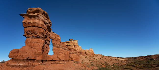
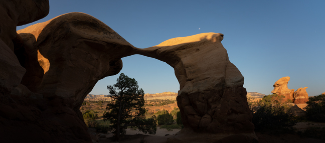
Reunion Double Arch (12S-490327-4205665, Span: 18 feet, Height: 15 ft. (largest opening))
By the next morning, the skies were clearing and we made our way down Notom-Bullfrog Road for 22 miles along the eastern boundary of Capitol Reef National Park to the Cedar Mesa Campground and the Reunion Arch Trailhead. It’s a 5.5 mile roundtrip hike to the arch, if you know where the side trail is. It’s a bit further if you don’t, but a relaxing shaded respite for us while the hike leaders searched the rugged terrain for the well-hidden arch. After an hour of difficult bushwhacking and a bit worse for wear, they led us to a relatively easy path to the arch and a nice spot for lunch.
©Rich Beckman
Burro Wash Arch (12S-490639-4226751, Span: 6 feet, Height: 15 feet)
Beautiful weather and nice morning light were a welcome sight the next day for our hike to Burrow Wash Arch and Secluded Arch. It’s only an easy 2.5 miles roundtrip hike to the arches, but that was hardly fulfilling for our hike leaders who decided we should continue down the wash for a few more miles where there are some slot canyons. Cynny, Marilyn and Joel thought we should just head back to the Jeep as they wanted to visit Cassidy Arch that afternoon, but I convinced them that we should continue on and that we would still have time for both a leisurely lunch and a hike to Cassidy arch for nice late afternoon light.
They reluctantly agreed and we continued with the group until the first major obstacle, a major choke stone lodged in the slot canyon, before heading back. We all suffered for my enthusiasm that afternoon as the first half mile of the 3.5 mile hike to Cassidy Arch features a 500-foot elevation gain.
©Rich Beckman
Secluded Arch (12S-490449-4226770, Span: 15 ft, Height: 8 feet) with Burro Wash Arch in the background
Beautiful weather and nice morning light were a welcome sight the next day for our hike to Burrow Wash Arch and Secluded Arch. It’s only an easy 2.5 miles roundtrip hike to the arches, but that was hardly fulfilling for our hike leaders who decided we should continue down the wash for a few more miles where there are some slot canyons. Cynny, Marilyn and Joel thought we should just head back to the Jeep as they wanted to visit Cassidy Arch that afternoon, but I convinced them that we should continue on and that we would still have time for both a leisurely lunch and a hike to Cassidy arch for nice late afternoon light.
They reluctantly agreed and we continued with the group until the first major obstacle, a major choke stone lodged in the slot canyon, before heading back. We all suffered for my enthusiasm that afternoon as the first half mile of the 3.5 mile hike to Cassidy Arch features a 500-foot elevation gain.
©Rich Beckman
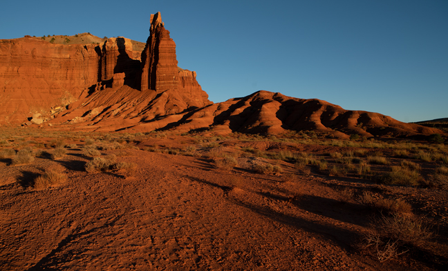
Chimney Rock, Capitol Reef National Park
On the way back from Cassidy Arch evening light was illuminating Chimney Rock, a 6,420-foot landmark three miles east of the Park’s western boundary on Utah Highway 24. A 3.6 mile trail ascends to the top of 500-foot-high Mummy Cliffs and overlooks the Moenkopi tower.
©Rich Beckman
Sheet’s Gulch Arch (12S-490436-4217154, Span: 25 feet, Height: 85 feet)
It’s a seven mile roundtrip hike to Sheet’s Gulch Arch on the east side of the Waterpocket Fold and half of the hike is through narrow canyons that feature significant choke stones. Due to recent rains, these sections were also muddy. With the able assistance of our guides we were able to overcome otherwise impassable obstacles and climb to the base of the arch where White Pale Evening Primrose was in bloom.
©Rich Beckman
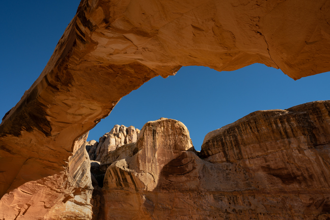
Hickman Bridge (12S-479502-4238178, Span: 130 feet, Height: 70 feet)
The rally continued for the remainder of the week, but we had been to Capitol Reef last year and wanted to explore a few areas of Grand Staircase-Escalante National Monument, so we said our fond farewells at the Wednesday evening group dinner and hiked up to Hickman Bridge by ourselves the next morning before heading down to Escalante, UT., about 65 miles to the south.
©Rich Beckman
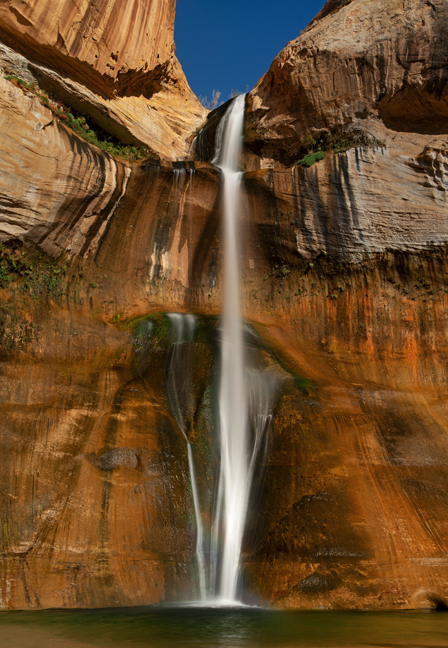
Lower Calf Creek Falls, Grand Staircase-Escalante National Monument
The hike to Lower Calf Creek Falls is a six-mile out-and-back hike off Utah Scenic Byway 12 between Escalante and Boulder, UT. The stream descends 126 feet into a pool where hikers swim in warmer weather. This is a popular hike and the large parking area fills and the trail gets crowded by mid-morning. We started just after sunrise and had the Falls to ourselves for about 20 minutes before a steady influx of hikers began to arrive.
©Rich Beckman
Mano Arch (12S-463468-4160004, Span: 25 feet , Height 11 feet)
The next morning we headed down Hole-in-the-Rock Road for 12 miles to Devils Garden to photograph Mano and Metate Arches in soft morning light as the moon was setting, before continuing another 30 miles to the Willow Gulch Trailhead to begin the 4.5 mile out and back hike to Broken Bow Arch. Hole-In-The Rock Road is a 62-mile rugged dirt road that runs between Escalante and Hole-in-the-Rock on the western shore of Lake Powell that follows the general route of the 1879 Mormon wagon train Hole-in-the-Rock expedition. Even in dry weather, a 4WD high-clearance vehicle is recommended, particularly for anyone driving beyond Dance Hall Rock.
©Rich Beckman
Metate Arch (12S-463529-4159719, Span: 16 feet, Height 22 feet)
The next morning we headed down Hole-in-the-Rock Road for 12 miles to Devils Garden to photograph Mano and Metate Arches in soft morning light as the moon was setting, before continuing another 30 miles to the Willow Gulch Trailhead to begin the 4.5 mile out and back hike to Broken Bow Arch. Hole-In-The Rock Road is a 62-mile rugged dirt road that runs between Escalante and Hole-in-the-Rock on the western shore of Lake Powell that follows the general route of the 1879 Mormon wagon train Hole-in-the-Rock expedition. Even in dry weather, a 4WD high-clearance vehicle is recommended, particularly for anyone driving beyond Dance Hall Rock.
©Rich Beckman
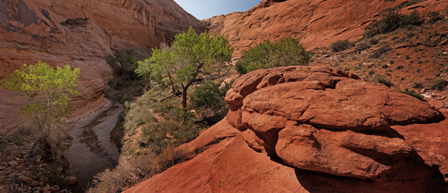
Willow Gulch Canyon, Grand Staircase-Escalante National Monument
The next morning we headed down Hole-in-the-Rock Road for 12 miles to Devils Garden to photograph Mano and Metate Arches in soft morning light as the moon was setting, before continuing another 30 miles to the Willow Gulch Trailhead to begin the 4.5 mile out and back hike to Broken Bow Arch. Hole-In-The Rock Road is a 62-mile rugged dirt road that runs between Escalante and Hole-in-the-Rock on the western shore of Lake Powell that follows the general route of the 1879 Mormon wagon train Hole-in-the-Rock expedition. Even in dry weather, a 4WD high-clearance vehicle is recommended, particularly for anyone driving beyond Dance Hall Rock.
©Rich Beckman
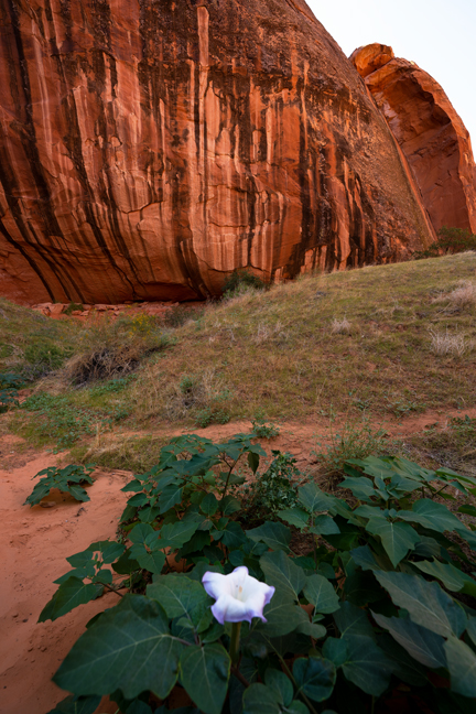
Downy Thorn Apple, Willow Gulch, Grand Staircase-Escalante National Monument
A Downy Thorn Apple blooms at the base of a desert varnish cliff in Willow Gulch adjacent to Broken Bow Arch. Downy Thorn Apple, one of nine members of the Datura genus, is a poisonous, vespertine-flowering plant belonging to the nightshade family Solanaceae. It is one of the oldest and most frequently abused psychoactive plant species, having been used as a poison and a hallucinogen for centuries.
The nearby cliff is covered in desert varnish, a thin coating (patina) of manganese, iron and clays that forms on the surface of sun-baked cliffs and boulders.
©Rich Beckman
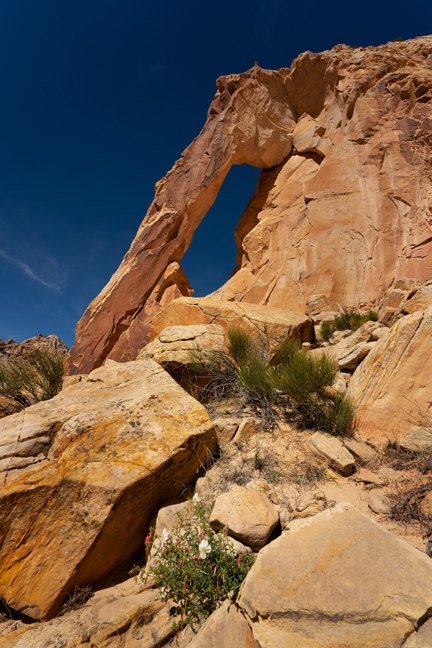
Broken Bow Arch (12S-499987-4131321, Span: 94 feet, Height: 106 Feet)
This Navajo Sandstone arch got its name when a local school teacher found a broken Native American bow under the arch in the 1930s. The hike to the arch requires numerous stream crossings and bypassing pooled water depending on recent rains. There are numerous confusing side trails, so GPS is recommended.
©Rich Beckman
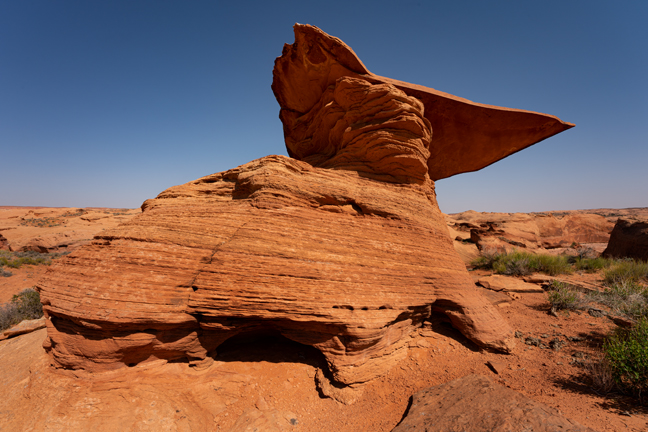
Mortarboard Rock, Willow Gulch, Grand Staircase-Escalante National Monument
The return to the trailhead requires a half mile climb up steep, sandy switchbacks to Mortarboard Rock followed by another ascent to the parking area. This, of course, is followed by a 45 mile drive back to Highway 12 on Hole-in-the-Rock Road.
The next morning we packed the Jeep, drove the 47-mile Cottonwood Canyon Road back to Big Water, then headed west to House Rock Road, an equally entertaining dirt road that stretches for approximately 30 miles between State Routes 89 in Utah and State Route 89A in Arizona. Our destination was the Vermilion Cliffs Condor Viewing site, 27 seven miles to the south where five California Condors would be released as part of the 26th annual event at noon.
From there we stopped at Navajo Bridge, a popular viewing area for California Condors, before heading to Camp Verde, our final stop, for a farewell dinner at Moscato Italian Restaurant. It was a perfect evening for outdoor dining and Moscato's is a must stop when overnighting in Camp Verde.
The next morning we made the 100-mile drive to Sky Harbor Airport in Phoenix, dropped off Marilyn and Joel in plenty of time for their flight back to Chicago and made the 90-mile drive back to Tucson where we had three full days at home before heading east for the second part of our journey.
©Rich Beckman
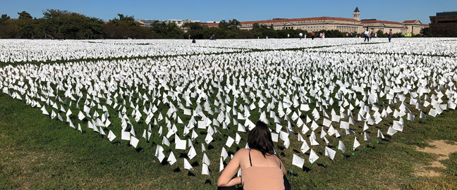
In America: Remember
We arrived in Washington, D.C. in time to visit Suzanne Brennan Firstenberg’s Covid-19 installation on the National Mall, an unfathomable sea of small white flags, each representing a life lost to Covid. The tote board read “In America: Remember 697,868." If the exhibit were still up, today it would read “In America: Remember 733,834." Since early summer nearly all COVID-19 deaths in the U.S. are people who weren’t vaccinated.
©Rich Beckman
Hamilton Falls, Jamaica, Vermont
After a few nights in Washington, visiting with daughter Emmie and great friends, we flew to Burlington, VT. for a week of hiking. When we went to pick up our rental car we had to wait until a clean car was available. It was a short wait, but probably because they hadn’t filled the car with gas or bothered to turn off the dashboard warning lights, that they assured us were meaningless.
Our first stop was Grafton, 135 miles to the south. It was already getting dark and raining by the time we started down the highway, but traffic was light and the only challenge was finding a restaurant that was open later than 8 p.m. We settled on the Black Rock Steakhouse in Springfield, VT and it was an interesting experience. We decided not to try an entrée ordered from the rock. We’re still not sure what than means, but apparently they bring you a volcanic sizzling rock and you cook your steak on the rock. Maybe next time. My leftovers fed us for the next two days, so you can imagine the portions.
Our first hike in Vermont was a 5.8 mile hike to Hamilton Falls. Unfortunately, or perhaps fortunately, the GPS led us to within a half mile of the falls rather than to the trailhead. As the short trail down to the falls was muddy from all the rain, we accepted our fate, photographed the falls and forwent the longer hike.
©Rich Beckman
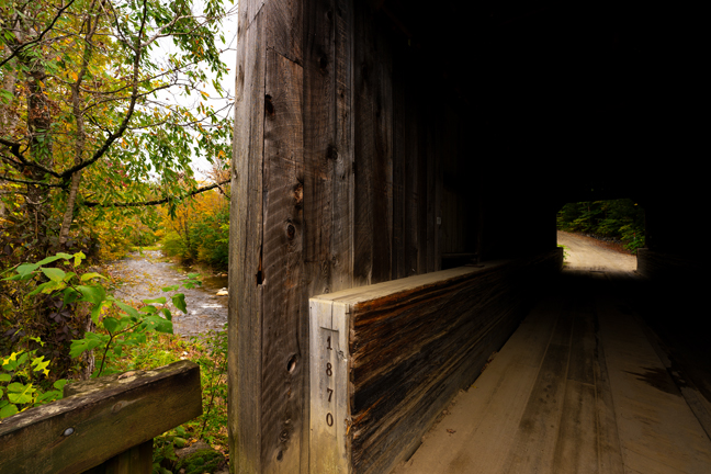
Kidder Hill Covered Bridge, Grafton, Vermont
Our abbreviated hike allowed us time to explore Grafton. That didn’t take very long as most things were closed, but we did find the Kidder Hill Covered Bridge. According to the Vermont Covered Bridge Society, the bridge is the only kingposter in Vermont that still has sway braces. I don’t know what that means but it’s the town’s last surviving 19th-century covered bridge and its listed on the National Register of Historic Places. Like many of the covered bridges in the area, it was damaged in 2011 when Tropical Storm Irene became a tropical cyclone striking Vermont.
©Rich Beckman
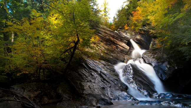
Falls of Lana, Salisbury, Vermont
Our next stop was Goshen, Vermont, about 70 miles north of Grafton. Here we would stay at the Blueberry Hill Inn, a place I had stayed more than 40 years ago and one of my favorite Vermont inns. It is expansive and has a network of hiking and cross-country skiing trails on the property. Nearby are Silver Lake and Falls of Lana. When we arrived at the trailhead, there wasn’t really a clear trail to Falls of Lana, but we explored the Silver Lake Trail and a few logical side trails in an attempt to find a way down to the base of the falls. We failed, but after further research we found the secret path and returned the next day to successfully complete our mission.
©Rich Beckman
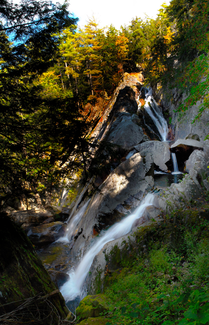
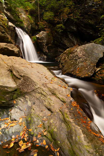
Texas Falls, Hancock, Vermont
A placard at the Silver Lake Trailhead listed Texas Falls as one of the most beautiful places in Vermont, so off we went. It is a popular roadside attraction in the Green Mountain National Forest, but with a bit of work you can access a lower viewpoint away from the crowds who linger on the bridge that passes high above the falls.
©Rich Beckman
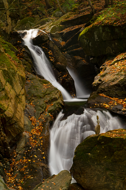
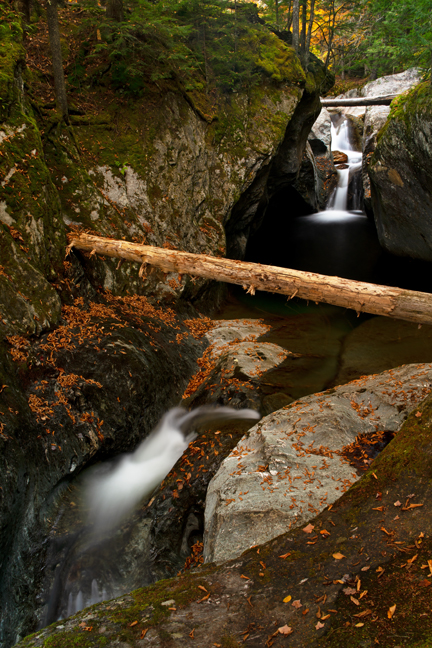
Honey Hollow Falls, Chittenden County, Vermont
Unlike Texas Falls, there are no crowds at Honey Hollow Falls. The falls are located in a deep wooded glen on the north slope of Camel's Hump (height 4,083 feet) in the Winooski River Valley. A few hundred vertical feet above the confluence with the Winooski River, the waters of Preston Brook descend through a series of small falls. You can access the falls from Honey Hollow Road or from the other side of the brook via the Catamount Ski Trail off Duxbury Road.
The balanced rock art was present when we arrived.
©Rich Beckman
Bingham Falls, Stowe, Vermont
Our final Vermont stop before returning to Burlington was in Waterbury, a small community ten miles south of Stowe, the area’s most famous tourist destination. Bingham Falls is within Mt. Mansfield State Forest off the east side of Upper Mountain Road. There is a trail down to the base of the falls, but a second set of lower falls requires climbing over large wet boulders and balancing on wet rocks. There have been a number of drownings and serious injuries at the falls, so caution is advised.
©Rich Beckman
Statue of Liberty, Liberty Island, New York Harbor
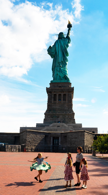
There is a member of the family who has a National Parks Passport Book. At nearly all of the 432 units of the U.S. National Park System, one or more ink stamps can be recorded. I guess I should be grateful that she is not a member of the Natural Park Travelers Club, a group of such stamp collectors who actually hold annual conventions. We rarely miss an opportunity to add stamps to said passport and our visit to New York City was no exception as we joined the masses to visit the Statue of Liberty, Ellis Island and other stamp-worthy locales. I follow along documenting both the lovely and the bizarre.
©Rich Beckman
Statue of Liberty, Liberty Island, New York Harbor
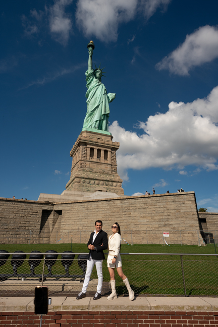
There is a member of the family who has a National Parks Passport Book. At nearly all of the 432 units of the U.S. National Park System, one or more ink stamps can be recorded. I guess I should be grateful that she is not a member of the Natural Park Travelers Club, a group of such stamp collectors who actually hold annual conventions. We rarely miss an opportunity to add stamps to said passport and our visit to New York City was no exception as we joined the masses to visit the Statue of Liberty, Ellis Island and other stamp-worthy locales. I follow along documenting both the lovely and the bizarre.
©Rich Beckman