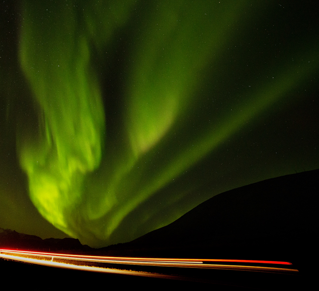
October 2019, Driving Under the Aurora, Kolgrafarfjördur, Iceland
Occasionally, in the midst of the Tucson summer, the heat adversely affects my decision-making and what seemed like a good idea at the time now seems a bit less appealing. Thus, we are in Iceland, spending a week in a VW camping van exploring the southern coast.
Surprisingly, in spite of the temperatures rarely and barely rising above freezing, there are hundreds of other people exploring many of the same sites, and an endless stream of large white tour buses stopping at places with unpronounceable names.
Last year 2.3 million tourists visited Iceland, a country of 350,000 residents. More people visited Iceland in the past decade than in the previous six decades combined. Even in the middle of the night, with temperatures ten degrees below freezing, photographers are lined up tripod-to-tripod to photograph the Aurora Borealis at the most popular sites. Even more than 100 miles from Reykyavík, tour buses show up for the sunrise at popular waterfalls, even when the sun does not.
The little we saw was beautiful, but we got there 20 years too late. I'm certain there are less touristy parts of the country that are less accessible and equally as beautiful. Hopefully, we'll return and have the time to explore.
©Rich Beckman
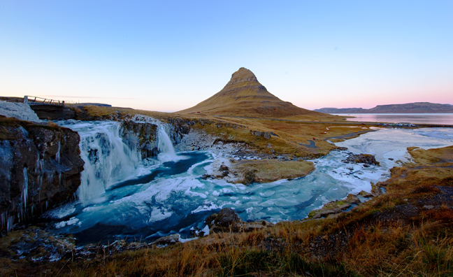
October 2019, Kirkjufellsfoss, Grundarfjörður, Iceland
Kirkjufellsfoss, or 'Church Mountain Falls' with Kirkjufell (1519 feet) in the background, is on the north shore of Iceland’s Snæfellsnes Peninsula, only a short distance from the town of Grundarfjörður.
©Rich Beckman
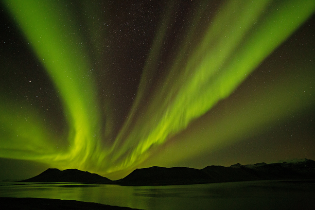
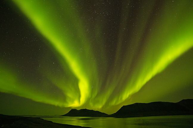
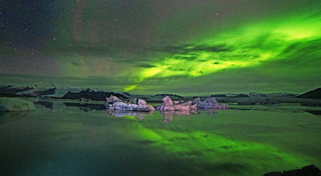
October 2019, Aurora Borealis, Kolgrafarfjördur, Iceland
The Aurora Borealis (Northern Lights) are the result of collisions between gaseous particles in the Earth's atmosphere and charged particles from the sun blown towards the Earth on the 'solar wind'. The Earth's magnetic field is weaker at either pole and therefore some particles enter the Earth's atmosphere and collide with gas particles. Color variations are due to the type of gas particles that are colliding. (1/3)
©Rich Beckman
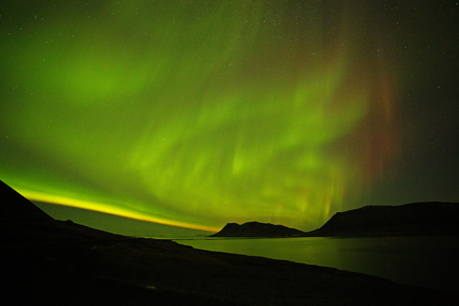
October 2019, Aurora Borealis, Kolgrafarfjördur, Iceland
The Aurora Borealis (Northern Lights) are the result of collisions between gaseous particles in the Earth's atmosphere and charged particles from the sun blown towards the Earth on the 'solar wind'. The Earth's magnetic field is weaker at either pole and therefore some particles enter the Earth's atmosphere and collide with gas particles. Color variations are due to the type of gas particles that are colliding. (2/3)
©Rich Beckman
October 2019, Aurora Borealis, Kolgrafarfjördur, Iceland
The Aurora Borealis (Northern Lights) are the result of collisions between gaseous particles in the Earth's atmosphere and charged particles from the sun blown towards the Earth on the 'solar wind'. The Earth's magnetic field is weaker at either pole and therefore some particles enter the Earth's atmosphere and collide with gas particles. Color variations are due to the type of gas particles that are colliding. (3/3)
©Rich Beckman

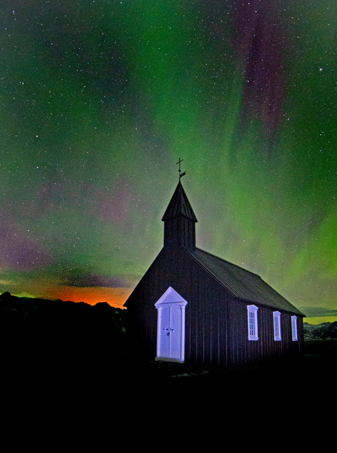
October 2019, Búðakirkja, Búðir, Iceland
On the south coast of Iceland’s Snæfellsnes peninsula, in the hamlet of Búðir there’s a tiny black church called the Búðakirkja. Búðir is within the Búðahraun lava field, an expansive environment of torn-up earth that is overgrown with grassy flora.
The first Búðakirkja was built on the same spot in 1703, but was deconstructed due to the lack of parishioners. The current church was reconstructed in 1987 after a single member lobbied to have the chapel brought back. It has a historic graveyard as well as relics such as a bell and chalice from the time the church was first erected.
The orange light behind the church is from a bonfire on the beach.
©Rich Beckman

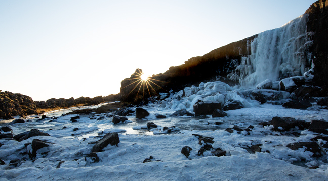
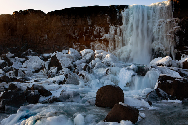
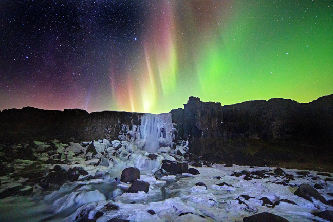
October 2019, Öxarárfoss, Þingvellir National Park, Iceland
Öxarárfoss is a situated within Þingvellir National Park in southwest Iceland. It flows from the Öxará River, cascading over the cliffs of Almannagiá Gorge, which marks the eastern boundary of the North American and Eurasian tectonic plates. It has a height of 44 feet and an average width of 20 feet.The National Park is one of the three famous sites of the Golden Circle along with Gullfoss waterfall and Geyser Geothermal Area.
Þingvellir was the original site of the Alþing, the Icelandic parliament founded in 930 AD. It was moved to Reykjavík nine centuries later. (1/3)
©Rich Beckman

October 2019, Öxarárfoss, Þingvellir National Park, Iceland
Öxarárfoss is a situated within Þingvellir National Park in southwest Iceland. It flows from the Öxará River, cascading over the cliffs of Almannagiá Gorge, which marks the eastern boundary of the North American and Eurasian tectonic plates. It has a height of 44 feet and an average width of 20 feet.The National Park is one of the three famous sites of the Golden Circle along with Gullfoss waterfall and Geyser Geothermal Area.
Þingvellir was the original site of the Alþing, the Icelandic parliament founded in 930 AD. It was moved to Reykjavík nine centuries later. (2/3)
©Rich Beckman

October 2019, Öxarárfoss, Þingvellir National Park, Iceland
Öxarárfoss is a situated within Þingvellir National Park in southwest Iceland. It flows from the Öxará River, cascading over the cliffs of Almannagiá Gorge, which marks the eastern boundary of the North American and Eurasian tectonic plates. It has a height of 44 feet and an average width of 20 feet.The National Park is one of the three famous sites of the Golden Circle along with Gullfoss waterfall and Geyser Geothermal Area.
Þingvellir was the original site of the Alþing, the Icelandic parliament founded in 930 AD. It was moved to Reykjavík nine centuries later. (3/3)
©Rich Beckman
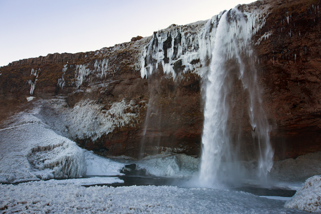
October 2019, Seljalandsfoss, Iceland
Seljalandsfoss, situated on the South Coast with a drop of 200 feet can be fully encircled most of the year, but the path was closed due to heavy ice accumulation during our visit. The falls is part of the Seljalandsá River and has its origins underneath the glacier Eyjafjallajökull. The volcano beneath this ice cap was the one that erupted in 2010.
©Rich Beckman

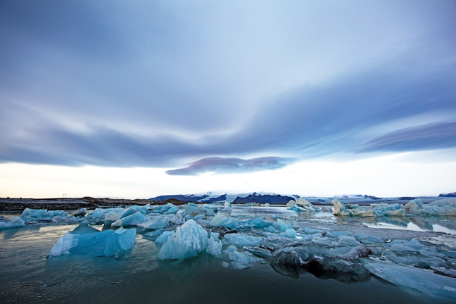
October 2019, Jökulsárlón, Iceland
Jökulsárlón, the country's most famous glacier lagoon is located in the southeast about halfway between the Skaftafell Nature Reserve and Höfn. It is a lake filled with the meltwater from Breiðamerkurjökull an outlet glacier, that is a tongue of Europe’s largest ice cap, Vatnajökull. It also fills with icebergs breaking from the glacier, some of which tower several stories high. When the icebergs finally make it across the lagoon, they either drift out to sea or wash up on the black sands of Breiðamerkursandur, nicknamed ‘the Diamond Beach’.
Jökulsárlón is the deepest lake in the Iceland, with depths of 814 feet and a surface area of seven square miles. It formed around 1935 due to rapidly rising temperatures in the country. Since 1920, Breiðamerkurjökull has been shrinking at a dramatic rate and the lagoon has begun to fill its space. Today, the expansion of Jökulsárlón is accelerating. In 1975, it had less than half its current surface area. In the relatively near future, it is expected that the lagoon will continue to grow until it becomes a large, deep fjord. (1/3)
©Rich Beckman

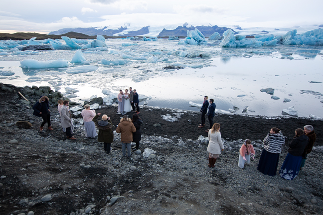
October 2019, Wedding on the Beach, Jökulsárlón, Iceland
Jökulsárlón, the country's most famous glacier lagoon is located in the southeast about halfway between the Skaftafell Nature Reserve and Höfn. It is a lake filled with the meltwater from Breiðamerkurjökull an outlet glacier, that is a tongue of Europe’s largest ice cap, Vatnajökull. It also fills with icebergs breaking from the glacier, some of which tower several stories high. When the icebergs finally make it across the lagoon, they either drift out to sea or wash up on the black sands of Breiðamerkursandur, nicknamed ‘the Diamond Beach’.
Jökulsárlón is the deepest lake in the Iceland, with depths of 814 feet and a surface area of seven square miles. It formed around 1935 due to rapidly rising temperatures in the country. Since 1920, Breiðamerkurjökull has been shrinking at a dramatic rate and the lagoon has begun to fill its space. Today, the expansion of Jökulsárlón is accelerating. In 1975, it had less than half its current surface area. In the relatively near future, it is expected that the lagoon will continue to grow until it becomes a large, deep fjord. (2/3)
©Rich Beckman

October 2019, Aurora Borealis over Jökulsárlón, Iceland
Jökulsárlón, the country's most famous glacier lagoon is located in the southeast about halfway between the Skaftafell Nature Reserve and Höfn. It is a lake filled with the meltwater from Breiðamerkurjökull an outlet glacier, that is a tongue of Europe’s largest ice cap, Vatnajökull. It also fills with icebergs breaking from the glacier, some of which tower several stories high. When the icebergs finally make it across the lagoon, they either drift out to sea or wash up on the black sands of Breiðamerkursandur, nicknamed ‘the Diamond Beach’.
Jökulsárlón is the deepest lake in the Iceland, with depths of 814 feet and a surface area of seven square miles. It formed around 1935 due to rapidly rising temperatures in the country. Since 1920, Breiðamerkurjökull has been shrinking at a dramatic rate and the lagoon has begun to fill its space. Today, the expansion of Jökulsárlón is accelerating. In 1975, it had less than half its current surface area. In the relatively near future, it is expected that the lagoon will continue to grow until it becomes a large, deep fjord. (3/3)
©Rich Beckman
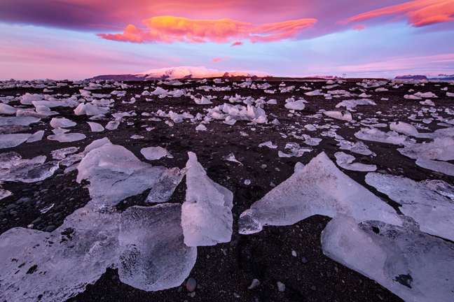

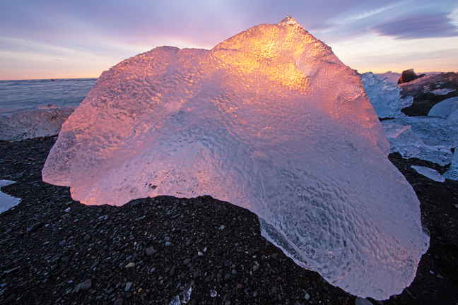
October 2019, Breiðamerkursandur (Diamond Beach), Iceland
Jökulsárlón, the country's most famous glacier lagoon is located in the southeast about halfway between the Skaftafell Nature Reserve and Höfn. It is a lake filled with the meltwater from Breiðamerkurjökull an outlet glacier, that is a tongue of Europe’s largest ice cap, Vatnajökull. It also fills with icebergs breaking from the glacier, some of which tower several stories high. When the icebergs finally make it across the lagoon, they either drift out to sea or wash up on the black sands of Breiðamerkursandur, nicknamed ‘the Diamond Beach’.
Jökulsárlón is the deepest lake in the Iceland, with depths of 814 feet and a surface area of seven square miles. It formed around 1935 due to rapidly rising temperatures in the country. Since 1920, Breiðamerkurjökull has been shrinking at a dramatic rate and the lagoon has begun to fill its space. Today, the expansion of Jökulsárlón is accelerating. In 1975, it had less than half its current surface area. In the relatively near future, it is expected that the lagoon will continue to grow until it becomes a large, deep fjord. (1/3)
©Rich Beckman

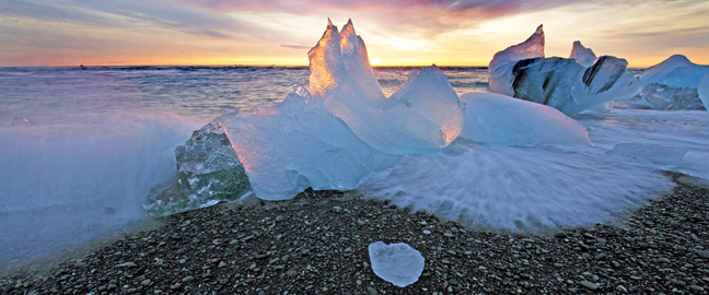
October 2019, Breiðamerkursandur (Diamond Beach), Iceland
Jökulsárlón, the country's most famous glacier lagoon is located in the southeast about halfway between the Skaftafell Nature Reserve and Höfn. It is a lake filled with the meltwater from Breiðamerkurjökull an outlet glacier, that is a tongue of Europe’s largest ice cap, Vatnajökull. It also fills with icebergs breaking from the glacier, some of which tower several stories high. When the icebergs finally make it across the lagoon, they either drift out to sea or wash up on the black sands of Breiðamerkursandur, nicknamed ‘the Diamond Beach’.
Jökulsárlón is the deepest lake in the Iceland, with depths of 814 feet and a surface area of seven square miles. It formed around 1935 due to rapidly rising temperatures in the country. Since 1920, Breiðamerkurjökull has been shrinking at a dramatic rate and the lagoon has begun to fill its space. Today, the expansion of Jökulsárlón is accelerating. In 1975, it had less than half its current surface area. In the relatively near future, it is expected that the lagoon will continue to grow until it becomes a large, deep fjord. (2/3)
©Rich Beckman

October 2019, Breiðamerkursandur (Diamond Beach), Iceland
Jökulsárlón, the country's most famous glacier lagoon is located in the southeast about halfway between the Skaftafell Nature Reserve and Höfn. It is a lake filled with the meltwater from Breiðamerkurjökull an outlet glacier, that is a tongue of Europe’s largest ice cap, Vatnajökull. It also fills with icebergs breaking from the glacier, some of which tower several stories high. When the icebergs finally make it across the lagoon, they either drift out to sea or wash up on the black sands of Breiðamerkursandur, nicknamed ‘the Diamond Beach’.
Jökulsárlón is the deepest lake in the Iceland, with depths of 814 feet and a surface area of seven square miles. It formed around 1935 due to rapidly rising temperatures in the country. Since 1920, Breiðamerkurjökull has been shrinking at a dramatic rate and the lagoon has begun to fill its space. Today, the expansion of Jökulsárlón is accelerating. In 1975, it had less than half its current surface area. In the relatively near future, it is expected that the lagoon will continue to grow until it becomes a large, deep fjord. (3/3)
©Rich Beckman

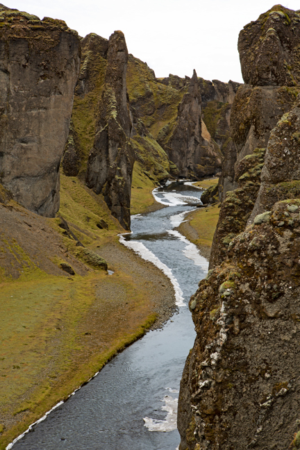
October 2019, Fjaðrárgljúfur Canyon, Kirkjubæjarklaustur, Iceland
Fjaðrárgljúfur Canyon, 328 feet deep and 1.25 miles long, is located in southeast Iceland close to Kirkjubæjarklaustur village. Gljúfur means canyon in Icelandic and Fjaðrá is the name of the river that runs through it. The canyon floor is closed most of the year to avoid damage to the fragile ecosystem. The site has become more popular after being featured in Justin Bieber's 2015 "I'll Show You" music video.
©Rich Beckman
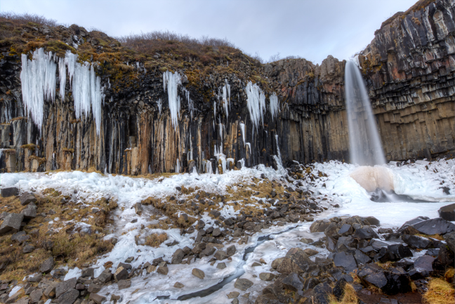
October 2019, Svartifoss, Skaftafell Visitor Center, Iceland
Svartifoss, known as ‘the Black Waterfall’ drops 65 feet from a crescent-shaped cliff, composed of hexagonal black basalt columns. Basaltic lava is hotter and flows faster than other forms of lava, and as it cools it forms hexagonal forms. This process is known as columnar jointing. Svartifoss is located a short uphill hike from Skaftafell Visitor Center at Skaftafell National Park in the southeast of Iceland.
©Rich Beckman
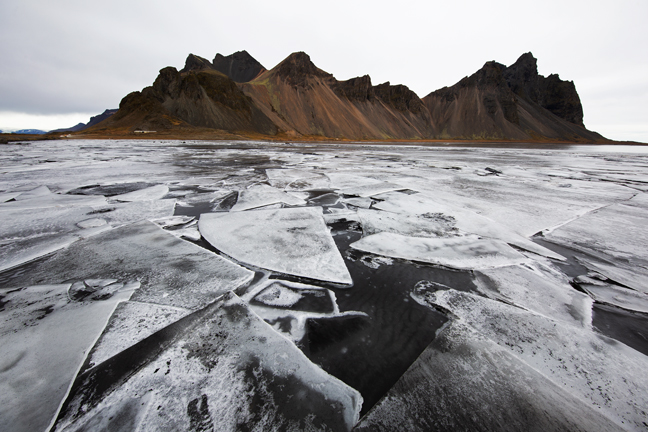
October 2019, Vestrahorn, Stokksnes Peninsula, Iceland
Vestrahorn, on the Stokksnes Peninsula in Southeast Iceland has peaks reaching 1490 feet, steep cliffs rising from the sides of a lagoon, and is surrounded by black sand beaches. The Stokksnes Peninsula has an interesting history stretching back to the 9th century, with Horn being one of the country’s first settlements; it was also a vital outpost for the British army during World War II.
©Rich Beckman
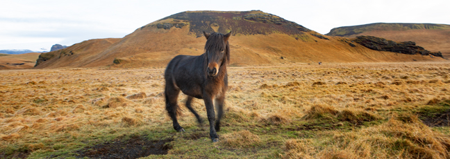
October 2019, Icelandic Horse, Reynisfjara, Iceland
The Icelandic Horse is the only breed of horse in Iceland. Although pony-sized, they are referred to as horses and are long-lived. They have no natural predators and no livestock of any species can be imported into the country. Once horses leave the country they are not allowed to return. The breed has been pure bred in Iceland for more than 1,000 years.
©Rich Beckman
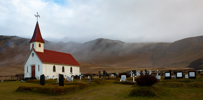
October 2019, Reyniskirkja Church, Reynisfjara, Iceland
Reyniskirkja Church is a Luthern church built in 1929 against the backdrop of Mt. Reynisfjall on the road down to Reynisfjara.
©Rich Beckman
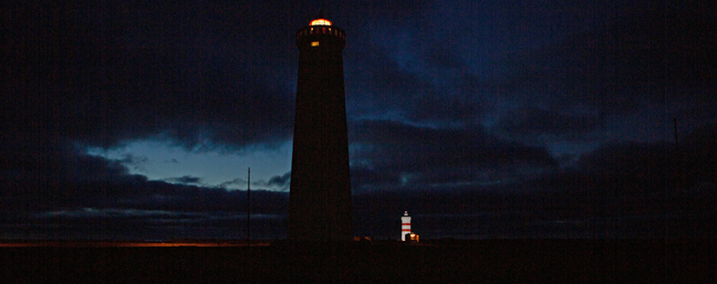
October 2019, Garðskagi Lighthouses, Garðskagi, Iceland
There are two lighthouses on Garðskagi. The old Garðskagi Lighthouse was built in 1897 and the new lighthouse in 1944. The older and smaller of the two was once regarded as one of the best lighthouses in Iceland because it stood low and therefore mist was not a problem. However, there was a risk of the lighthouse being damaged because of surf and it was sometimes not visible because of storms. At 92 feet, the new lighthouse is the tallest in Iceland and also serves as a radar transponder and weather station.
©Rich Beckman