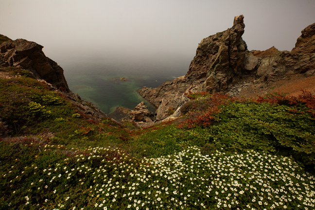
June 2019, Spiller's Cove, Twillingate, NL
There are many ways to plan a road trip to the Canadian Atlantic Provinces. Having been to New Brunswick and Nova Scotia previously and not that interested in the beaches of PEI, we decided to concentrate on Newfoundland and then to spend a few days in Nova Scotia and Prince Edward Island on our way back to the States.
We visited Emmie in Washington, D.C. the first week of June, and then spent a week in Maine, split between Vinalhaven Island and Acadia National Park before driving to North Sydney, Nova Scotia for our ferry to Newfoundland. There are two ferry routes from Nova Scotia to Newfoundland, but only one that was in operation on our departure date, so we disembarked at Port aux Basques on the southwest coast. You can't really circumvent Newfoundland by car, as there is no road across the southern coast. We decided to spend a day driving across the island and then to slowly circle back to Port aux Bosques rather than to circle the island clockwise and return to Nova Scotia on the 16-hour ferry from Argentia.
When planning our stops, the weather was an important consideration. I wanted to photograph some of Newfoundland's historic lighthouses, its natural arches, a few waterfalls, two renowned birding hotspots and two national parks. Because coastal Newfoundland is known for its dense fog, cloud cover and summer rains, I knew that we'd have many days without the quality of light I sought. Therefore, the most important locations required multi-day stays and we would either get lucky or not everywhere else.
This plan worked out pretty well and we only missed a few sites. We had at least a few moments of nice light almost everywhere, interspersed with some combination of dense fog, heavy cloud cover and occasional rain. Most of the heavy rain was on driving days, which was both a blessing and a curse, as the roads in Newfoundland don't drain well.
For some unexplainable reason, even the Trans Canada Highway has tire channels that quickly fill with water, leaving you three options: you can drive on the left hugging the centerline, drive on the right along the crumbling shoulder or hydroplane down the middle at 110 km/hr. In reality, a combination of all three is required depending on the size and speed of the oncoming traffic.
Our start date was predicated on visiting Emmie before she left for her summer associate assignment in Sweden, photographing northern gannets on Bird Rock at Cape St. Mary's Ecological Reserve (the third-largest nesting site and southernmost colony of northern gannets on the continent) and photographing Atlantic Puffins in Elliston on the Bonavista Peninsula. Both bird colonies would be flourishing by mid-to-late June and nothing else on our agenda was time sensitive, although icebergs are more common in June and early July.
©Rich Beckman
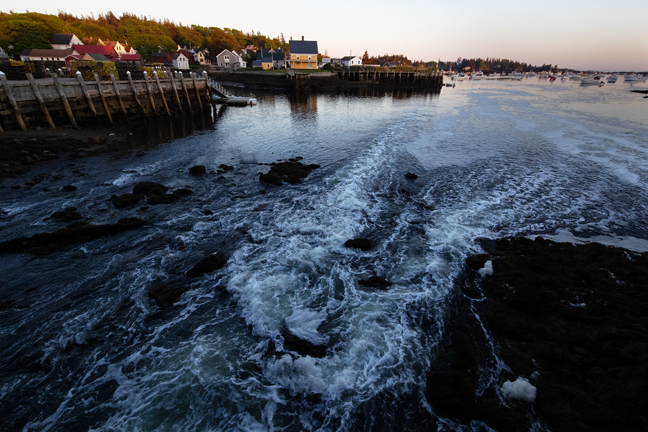
June 2019, Tidal Rush, Vinalhaven, ME
The Tidewater Inn is a family-owned inn perched on a bridge over the twice-daily tidal rush. Late spring tides run between 8-12 feet, so there is usually a torrent of water directly under your room. The inn is located on Main Street, really the only street, in downtown.
Between The Vinalhaven Land Trust, The Maine Coast Heritage Trust and The Nature Conservancy, there are more than two-dozen hiking trails interspersed throughout the island. Taking a car to the island on the Maine State Ferry is a challenge, as there is an antiquated, dysfunctional reservation system, but there is no other way to get around the island. The folks at the Tidewater can help facilitate ferry transport from Rockland. Do yourself a favor and leave time on your drive to Rockland to stop for a piece of homemade pie at Moody's Diner in Waldoboro. The same family has owned and operated it since 1927. They ship their homemade donuts and whoopee pies anywhere in the continental U.S. It's that kind of place.
©Rich Beckman
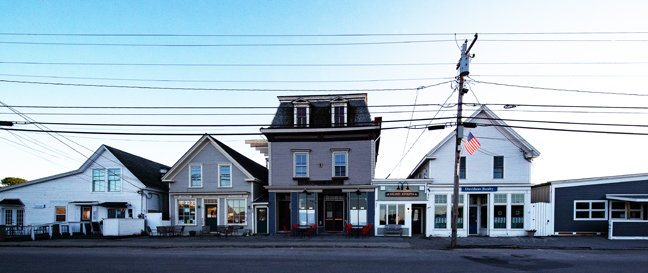
June 2019, Main Street, Vinalhaven, ME
The Tidewater Inn is a family-owned inn perched on a bridge over the twice-daily tidal rush. Late spring tides run between 8-12 feet, so there is usually a torrent of water directly under your room. The inn is located on Main Street, really the only street, in downtown.
Between The Vinalhaven Land Trust, The Maine Coast Heritage Trust and The Nature Conservancy, there are more than two-dozen hiking trails interspersed throughout the island. Taking a car to the island on the Maine State Ferry is a challenge, as there is an antiquated, dysfunctional reservation system, but there is no other way to get around the island. The folks at the Tidewater can help facilitate ferry transport from Rockland. Do yourself a favor and leave time on your drive to Rockland to stop for a piece of homemade pie at Moody's Diner in Waldoboro. The same family has owned and operated it since 1927. They ship their homemade donuts and whoopee pies anywhere in the continental U.S. It's that kind of place.
©Rich Beckman
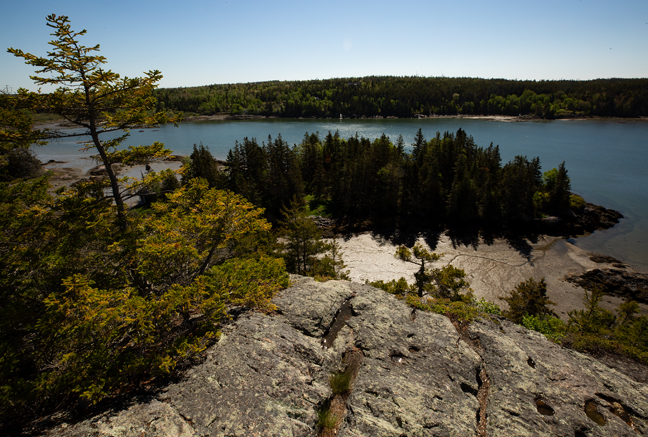
June 2019, Whitmore Pond, Vinalhaven, ME
The Tidewater Inn is a family-owned inn perched on a bridge over the twice-daily tidal rush. Late spring tides run between 8-12 feet, so there is usually a torrent of water directly under your room. The inn is located on Main Street, really the only street, in downtown.
Between The Vinalhaven Land Trust, The Maine Coast Heritage Trust and The Nature Conservancy, there are more than two-dozen hiking trails interspersed throughout the island. Taking a car to the island on the Maine State Ferry is a challenge, as there is an antiquated, dysfunctional reservation system, but there is no other way to get around the island. The folks at the Tidewater can help facilitate ferry transport from Rockland. Do yourself a favor and leave time on your drive to Rockland to stop for a piece of homemade pie at Moody's Diner in Waldoboro. The same family has owned and operated it since 1927. They ship their homemade donuts and whoopee pies anywhere in the continental U.S. It's that kind of place.
©Rich Beckman
June 2019, View, Big Tip Toe Mountain, Vinalhaven, ME
The Tidewater Inn is a family-owned inn perched on a bridge over the twice-daily tidal rush. Late spring tides run between 8-12 feet, so there is usually a torrent of water directly under your room. The inn is located on Main Street, really the only street, in downtown.
Between The Vinalhaven Land Trust, The Maine Coast Heritage Trust and The Nature Conservancy, there are more than two-dozen hiking trails interspersed throughout the island. Taking a car to the island on the Maine State Ferry is a challenge, as there is an antiquated, dysfunctional reservation system, but there is no other way to get around the island. The folks at the Tidewater can help facilitate ferry transport from Rockland. Do yourself a favor and leave time on your drive to Rockland to stop for a piece of homemade pie at Moody's Diner in Waldoboro. The same family has owned and operated it since 1927. They ship their homemade donuts and whoopee pies anywhere in the continental U.S. It's that kind of place.
©Rich Beckman
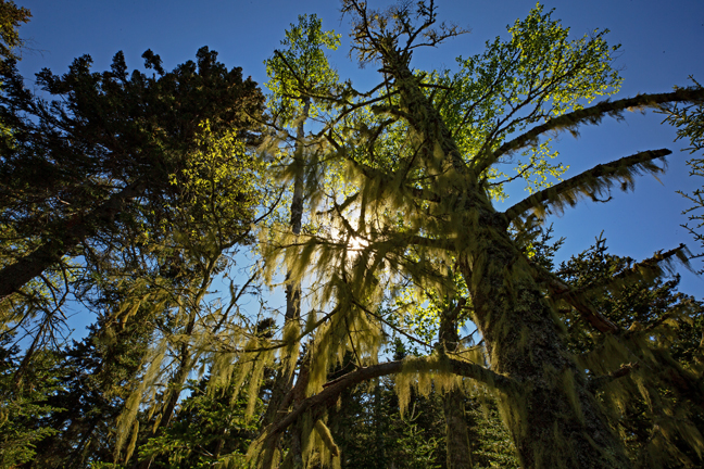
June 2019, Spanish Moss, Granite Island Trail, Vinalhaven, ME
The Tidewater Inn is a family-owned inn perched on a bridge over the twice-daily tidal rush. Late spring tides run between 8-12 feet, so there is usually a torrent of water directly under your room. The inn is located on Main Street, really the only street, in downtown.
Between The Vinalhaven Land Trust, The Maine Coast Heritage Trust and The Nature Conservancy, there are more than two-dozen hiking trails interspersed throughout the island. Taking a car to the island on the Maine State Ferry is a challenge, as there is an antiquated, dysfunctional reservation system, but there is no other way to get around the island. The folks at the Tidewater can help facilitate ferry transport from Rockland. Do yourself a favor and leave time on your drive to Rockland to stop for a piece of homemade pie at Moody's Diner in Waldoboro. The same family has owned and operated it since 1927. They ship their homemade donuts and whoopee pies anywhere in the continental U.S. It's that kind of place.
©Rich Beckman
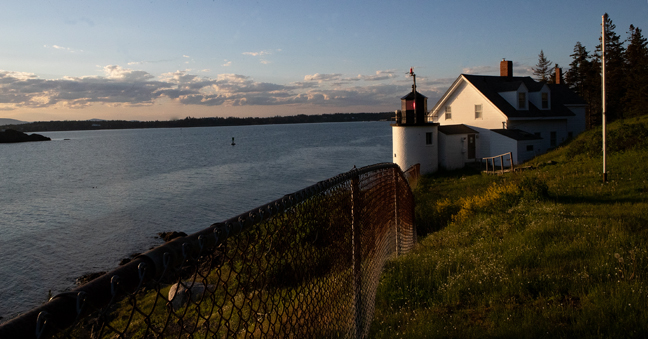
June 2019, Brown's Head Lighthouse Lighthouse, Vinalhaven, ME
Brown's Head Lighthouse marks the southern side of the western entrance of Fox Island Thoroughfare separating Vinalhaven Island from North Haven Island. The present lighthouse was built in 1857 and is listed on the National Register of Historic Places.
The Tidewater Inn is a family-owned inn perched on a bridge over the twice-daily tidal rush. Late spring tides run between 8-12 feet, so there is usually a torrent of water directly under your room. The inn is located on Main Street, really the only street, in downtown.
Between The Vinalhaven Land Trust, The Maine Coast Heritage Trust and The Nature Conservancy, there are more than two-dozen hiking trails interspersed throughout the island. Taking a car to the island on the Maine State Ferry is a challenge, as there is an antiquated, dysfunctional reservation system, but there is no other way to get around the island. The folks at the Tidewater can help facilitate ferry transport from Rockland. Do yourself a favor and leave time on your drive to Rockland to stop for a piece of homemade pie at Moody's Diner in Waldoboro. The same family has owned and operated it since 1927. They ship their homemade donuts and whoopee pies anywhere in the continental U.S. It's that kind of place.
©Rich Beckman
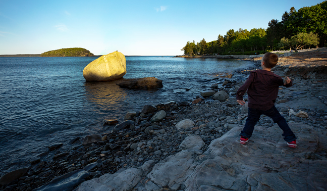
June 2019, Rock Toss, Bar Harbor, ME
This glacier boulder sits on the beach along The Shore Path in Bar Harbor at low tide, but as the tide rises it becomes a target for stones thrown from shore. As it was explained to me in some detail, the goal is to land your stone on top of the boulder.
Bar Harbor is the bustling tourist town that borders Acadia National Park on Mount Desert Island. It is also the former and future location of the ferry terminal for transport to and from Yarmouth, NS. It was supposed to re-open after a two-year hiatus on June 21, but our reservations were cancelled for both our departure and our mid-July return, so don't count on it being functional this summer.
The Park protects the highest rocky headlands of the Atlantic Coast, but it features city-like traffic and a shortage of parking for its annual 3.4 million visitors.
©Rich Beckman
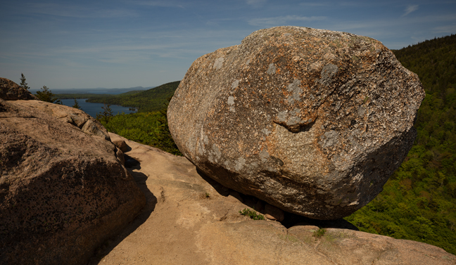
June 2019, Bubble Rock, Acadia National Park, Bar Harbor, ME
The best known boulder in the state of Maine sits precariously on the eastern edge of the summit of South Bubble Mountain. It is a glacial erratic left sitting after glacial melt. Scientists theorize from its course-grained white granite composition that it originated about 40 miles to the north from near Lucerne.
Bar Harbor is the bustling tourist town that borders Acadia National Park on Mount Desert Island. It is also the former and future location of the ferry terminal for transport to and from Yarmouth, NS. It was supposed to re-open after a two-year hiatus on June 21, but our reservations were cancelled for both our departure and our mid-July return, so don't count on it being functional this summer.
The Park protects the highest rocky headlands of the Atlantic Coast, but it features city-like traffic and a shortage of parking for its annual 3.4 million visitors.
©Rich Beckman
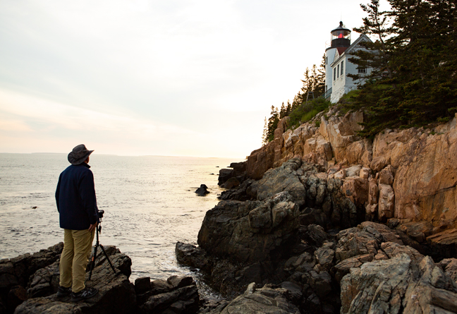
June 2019, Bass Harbor Lighthouse, Acadia National Park, Tremont, ME
The rocks below the Bass Harbor Lighthouse attract dozens of photographers each evening although there are only a couple of good vantage points, so arrive early and be prepared to protect your line of sight.
Bar Harbor is the bustling tourist town that borders Acadia National Park on Mount Desert Island. It is also the former and future location of the ferry terminal for transport to and from Yarmouth, NS. It was supposed to re-open after a two-year hiatus on June 21, but our reservations were cancelled for both our departure and our mid-July return, so don't count on it being functional this summer.
The Park protects the highest rocky headlands of the Atlantic Coast, but it features city-like traffic and a shortage of parking for its annual 3.4 million visitors.
©Rich Beckman
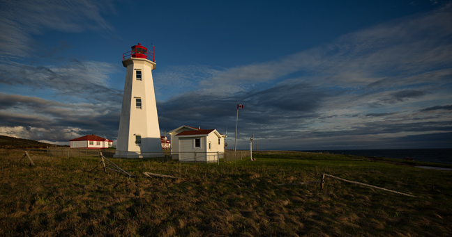
June 2019, Cape Anguille Lighthouse, Cape Anguille, NL
After the 600-mile drive from Bar Harbor to North Sydney, we caught the ferry to Port aux Basques, Newfoundland. It arrived in the early evening and our first stop was the Cape Anguille Lighthouse Inn, about 40 miles from the ferry terminal. The winds were howling and roadside signs advised trucks and RVs that driving conditions were perilous. It was challenging simply to walk outside to photograph the lighthouse. There was a short window during which the setting sun broke through the low clouds and illuminated the restored century-old light-keepers home that is a Newfoundland Registered Heritage Structure.
Throughout Newfoundland, we found that restaurants that "stay open late" close at 9 p.m., but 8 p.m. is a more common closing time, particularly in rural areas. With sunset at or after 9 p.m. this was a regular challenge for golden hour light. Just to make things confusing, Newfoundland has its own time zone that is 90 minutes ahead of Eastern Daylight Time during the summer. We found dinner at the bar of a closed restaurant and ate bar food fresh from the freezer, adjacent to three locals playing second-hand slot machines.
©Rich Beckman
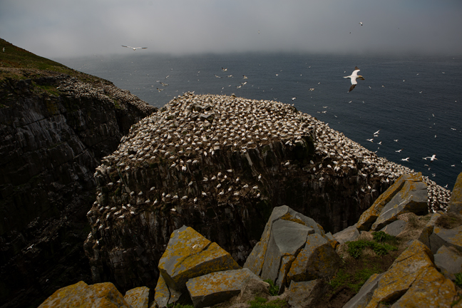
June 2019, Cape St. Mary's Ecological Preserve, St. Brides, NL
We decided to spend two days driving to Saint Brides, the closest lodging to Cape St. Mary's Ecological Preserve, partially to stopover in Gander, where 38 planes with nearly 6,700 "come from aways" (as Newfoundlanders call anyone not from the island) were forced to land when USA airspace was shutdown following the 9/11 bombings. A piece of steel from one of the original towers is now housed in the North Atlantic Aviation Museum in Gander. In the early 1940s the airport was the largest in the world and it remained a vital refueling stop for trans-Atlantic flights until the 1960s when most flights no longer needed to refuel for the journey. Gander was also the site of Canada's deadliest air disaster when Arrow Air Flight 1285, a McDonnell Douglas DC-8, crashed during takeoff with 256 people onboard.
The eight-mile drive from NL-100 to the Cape St. Mary's Ecological Reserve Visitor's Center along Lear's Cove Rd. is rarely boring. The shoulder-less two-way road is barely wide enough for two cars, so encountering a large RV traveling in the opposite direction was always fun. When you factor in the thick fog that often obscures everything more than an arm's length away, the drive was even more interesting.
During our two days in the area, we had two hours one evening and two hours one morning when it was clear enough to photograph the thousands of sea birds nesting on Bird Rock and the adjacent cliffs. The fog comes and goes quickly and it can be thick along the road yet clear at the Rock, so don’t judge conditions by the weather in St. Brides, along the road or at the Visitor Center. If you do, you may miss one of the most accessible and spectacular sea bird colonies in the world. (See: Newfoundland Birding Hotspots under the International Wildlife Hotspots tab.)
©Rich Beckman
June 2019, Cape Race Lighthouse, Avalon Peninsula, NL
Our next stop was Trepassey on the southern tip of the Avalon Peninsula. Trepassey Harbor was where, in 1928, Amelia Earhart, as a passenger, boarded the "Friendship," and became the first woman to fly across the Atlantic. It is also one of the many Newfoundland communities devastated by the depletion of cod and the collapse of the cod fisheries that saw more than 35,000 fishermen and plant workers lose their jobs across more than 400 Newfoundland coastal communities.
We visited the Cape Race Lighthouse, which in April 1912 received the Titanic distress call, Cape Pine Lighthouse and Mistaken Point World Heritage Site, a globally significant Ediacaran fossil site that contains the oldest known assemblages of large fossils in the world. It preserves a record of the appearance of biologically complex organisms, after almost three billion years of micro-dominated evolution.
©Rich Beckman
June 2019, Cape Pine Lighthouse, Avalon Peninsula, NL
Our next stop was Trepassey on the southern tip of the Avalon Peninsula. Trepassey Harbor was where, in 1928, Amelia Earhart, as a passenger, boarded the "Friendship," and became the first woman to fly across the Atlantic. It is also one of the many Newfoundland communities devastated by the depletion of cod and the collapse of the cod fisheries that saw more than 35,000 fishermen and plant workers lose their jobs across more than 400 Newfoundland coastal communities.
We visited the Cape Race Lighthouse, which in April 1912 received the Titanic distress call, Cape Pine Lighthouse and Mistaken Point World Heritage Site, a globally significant Ediacaran fossil site that contains the oldest known assemblages of large fossils in the world. It preserves a record of the appearance of biologically complex organisms, after almost three billion years of micro-dominated evolution.
©Rich Beckman
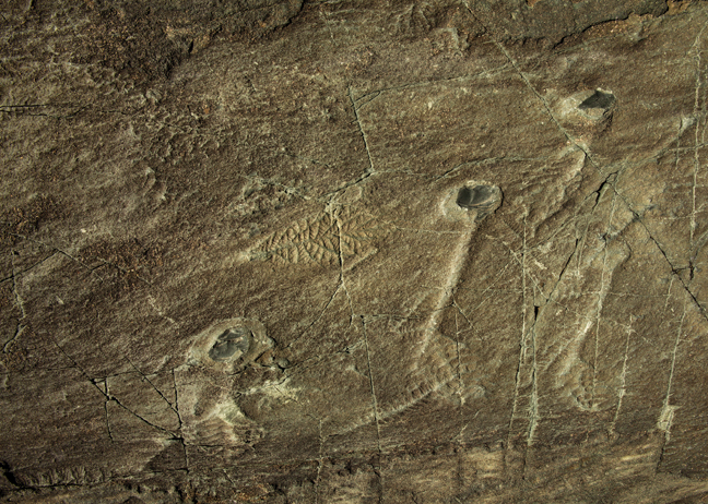
June 2019, Mistaken Point World Heritage Site, Avalon Peninsula, NL
Our next stop was Trepassey on the southern tip of the Avalon Peninsula. Trepassey Harbor was where, in 1928, Amelia Earhart, as a passenger, boarded the "Friendship," and became the first woman to fly across the Atlantic. It is also one of the many Newfoundland communities devastated by the depletion of cod and the collapse of the cod fisheries that saw more than 35,000 fishermen and plant workers lose their jobs across more than 400 Newfoundland coastal communities.
We visited the Cape Race Lighthouse, which in April 1912 received the Titanic distress call, Cape Pine Lighthouse and Mistaken Point World Heritage Site, a globally significant Ediacaran fossil site that contains the oldest known assemblages of large fossils in the world. It preserves a record of the appearance of biologically complex organisms, after almost three billion years of micro-dominated evolution.
©Rich Beckman
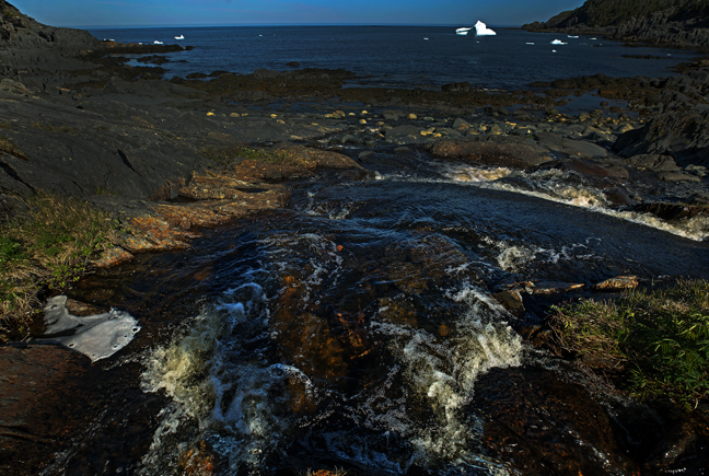
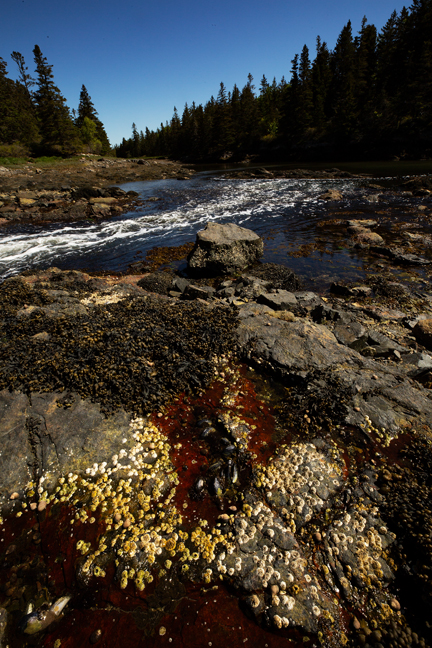
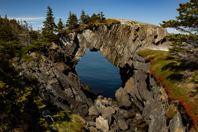
June 2019, Founder Cove, Spurwick Island Path, East Coast Trail, The Irish Loop, NL
The following morning, we drove up to Port Kirwan to hike the Spurwick Island Path of the East Coast Trail to Berry Head Arch. It is a 4.7-mile hike to the arch. Since we didn't have a shuttle, we hiked out to the arch and then back to the Port Kirwan where we had parked. The trail was in good condition except for the last mile or so, which was very muddy with numerous steep uphill sections. We had lunch along a beautiful stream at Founder Cove with a view of an iceberg. The East Coast Trail is an interconnected series of 26 wilderness paths along the eastern Newfoundland coast. Berry Head Arch has a greater arch dimension of 25 feet and the highest point of the 32-foot thick span is almost 60 feet above the sea.
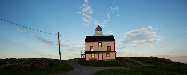
After getting slightly lost on our return to Port Kirwan, we had dinner at Bernard Kavanagh's Million Dollar View Restaurant (formally known as the Irish Loop Drive Restaurant), and then visited the Ferryland Lighthouse. The round, cylindrical tower was built of stone and red brick in 1870-71 and still retains its original lantern room. Ferryland Lighthouse Picnics is co-owned by Jill Curran whose great-grandfather John Costello was a Ferryland Lighthouse keeper and whose grandmother was born there.
Kavanagh is a local businessman who bought his first delivery truck in1958 and started a business selling potatoes out of his basement. At one time, his businesses supported more than 200 employees in the area. In the 1970s he purchased the two-story wooden structure along a cobble beach in Ferryland that had been used by the Goodridge Merchant Firm for the storage of salt fish beginning in the 1920s. Today it is named the Bernard Kavanagh Premises Municipal Heritage Site due to its aesthetic, historic and cultural significance.
The following morning, we drove up to Port Kirwan to hike the Spurwick Island Path of the East Coast Trail to Berry Head Arch. It is a 4.7-mile hike to the arch. Since we didn't have a shuttle, we hiked out to the arch and then back to the Port Kirwan where we had parked. The trail was in good condition except for the last mile or so, which was very muddy with numerous steep uphill sections. We had lunch along a beautiful stream at Founder Cove with a view of an iceberg. The East Coast Trail is an interconnected series of 26 wilderness paths along the eastern Newfoundland coast. Berry Head Arch has a greater arch dimension of 25 feet and the highest point of the 32-foot thick span is almost 60 feet above the sea.
After getting slightly lost on our return to Port Kirwan, we had dinner at Bernard Kavanagh's Million Dollar View Restaurant (formally known as the Irish Loop Drive Restaurant), and then visited the Ferryland Lighthouse. The round, cylindrical tower was built of stone and red brick in 1870-71 and still retains its original lantern room. Ferryland Lighthouse Picnics is co-owned by Jill Curran whose great-grandfather John Costello was a Ferryland Lighthouse keeper and whose grandmother was born there.
Kavanagh is a local businessman who bought his first delivery truck in1958 and started a business selling potatoes out of his basement. At one time, his businesses supported more than 200 employees in the area. In the 1970s he purchased the two-story wooden structure along a cobble beach in Ferryland that had been used by the Goodridge Merchant Firm for the storage of salt fish beginning in the 1920s. Today it is named the Bernard Kavanagh Premises Municipal Heritage Site due to its aesthetic, historic and cultural significance.
©Rich Beckman
June 2019, Berry Head Arch, Spurwick Island Path, East Coast Trail, The Irish Loop, NL
The following morning, we drove up to Port Kirwan to hike the Spurwick Island Path of the East Coast Trail to Berry Head Arch. It is a 4.7-mile hike to the arch. Since we didn't have a shuttle, we hiked out to the arch and then back to the Port Kirwan where we had parked. The trail was in good condition except for the last mile or so, which was very muddy with numerous steep uphill sections. We had lunch along a beautiful stream at Founder Cove with a view of an iceberg. The East Coast Trail is an interconnected series of 26 wilderness paths along the eastern Newfoundland coast. Berry Head Arch has a greater arch dimension of 25 feet and the highest point of the 32-foot thick span is almost 60 feet above the sea.
After getting slightly lost on our return to Port Kirwan, we had dinner at Bernard Kavanagh's Million Dollar View Restaurant (formally known as the Irish Loop Drive Restaurant), and then visited the Ferryland Lighthouse. The round, cylindrical tower was built of stone and red brick in 1870-71 and still retains its original lantern room. Ferryland Lighthouse Picnics is co-owned by Jill Curran whose great-grandfather John Costello was a Ferryland Lighthouse keeper and whose grandmother was born there.
Kavanagh is a local businessman who bought his first delivery truck in1958 and started a business selling potatoes out of his basement. At one time, his businesses supported more than 200 employees in the area. In the 1970s he purchased the two-story wooden structure along a cobble beach in Ferryland that had been used by the Goodridge Merchant Firm for the storage of salt fish beginning in the 1920s. Today it is named the Bernard Kavanagh Premises Municipal Heritage Site due to its aesthetic, historic and cultural significance.
©Rich Beckman
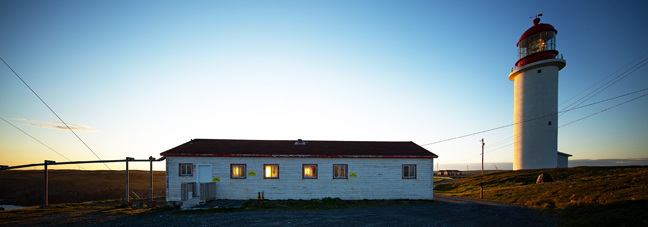
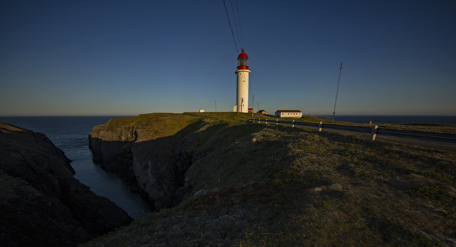
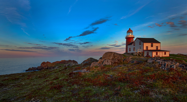
June 2019, Ferryland Lighthouse, Ferryland, The Irish Loop, NL
The following morning, we drove up to Port Kirwan to hike the Spurwick Island Path of the East Coast Trail to Berry Head Arch. It is a 4.7-mile hike to the arch. Since we didn't have a shuttle, we hiked out to the arch and then back to the Port Kirwan where we had parked. The trail was in good condition except for the last mile or so, which was very muddy with numerous steep uphill sections. We had lunch along a beautiful stream at Founder Cove with a view of an iceberg. The East Coast Trail is an interconnected series of 26 wilderness paths along the eastern Newfoundland coast. Berry Head Arch has a greater arch dimension of 25 feet and the highest point of the 32-foot thick span is almost 60 feet above the sea.
After getting slightly lost on our return to Port Kirwan, we had dinner at Bernard Kavanagh's Million Dollar View Restaurant (formally known as the Irish Loop Drive Restaurant), and then visited the Ferryland Lighthouse. The round, cylindrical tower was built of stone and red brick in 1870-71 and still retains its original lantern room. Ferryland Lighthouse Picnics is co-owned by Jill Curran whose great-grandfather John Costello was a Ferryland Lighthouse keeper and whose grandmother was born there.
Kavanagh is a local businessman who bought his first delivery truck in1958 and started a business selling potatoes out of his basement. At one time, his businesses supported more than 200 employees in the area. In the 1970s he purchased the two-story wooden structure along a cobble beach in Ferryland that had been used by the Goodridge Merchant Firm for the storage of salt fish beginning in the 1920s. Today it is named the Bernard Kavanagh Premises Municipal Heritage Site due to its aesthetic, historic and cultural significance.
©Rich Beckman