
July 2017: Western Salsify seed head, Custer State Park, SD
The Dakota Territory, the northwest corner of the land acquired from France in the Louisiana Purchase was originally much larger than the area of the two present Dakotas. When originally created in 1861, it included much of present-day Montana and Wyoming, part of Nebraska as well as all of the present-day Dakotas. By 1868, the Territory had been reduced to the present boundaries of the current Dakotas.
It was divided just below the 46th parallel when the two states entered the Union in 1889 as a ploy by Republicans to add two additional Senators, although it would have been more logical to create East and West Dakota as both halves of the former territory are divided by the Missouri River, a natural border, which enters in the northwest, and leaves it in the southeast.
Our exploration of "West Dakota" included three sites: Custer State Park, Wind Cave National Park and Theodore Roosevelt National Park.
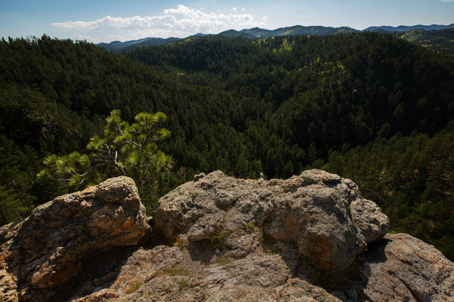
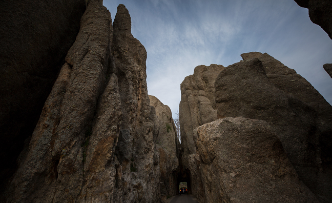
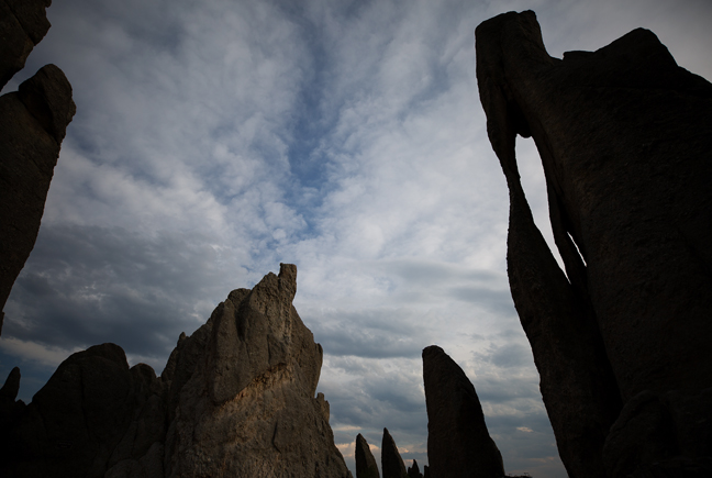
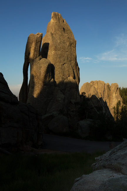
Custer State Park is one of the most impressive state parks in the country. It has four beautiful lodges, a variety of camp sites, historic sites, stunning scenic drives, trout fishing in four mountainous lakes, challenging hikes, a variety of wildlife, including a herd of 1,300 bison, and an iconic natural arch.
Less than 20 miles to the south of Custer State Park is Wind Cave National Park, the eighth national park established in the United States, protected since 1903. Long regarded as sacred by Native Americans, cave exploration did not begin until 1881, when two brothers, Jesse and Tom Bingham, noticed the entrance. They heard a loud whistling noise, which led them to a small hole in the ground, the cave's only natural opening.
As of 2017, 143.16 miles of passages have been mapped in Wind Cave, making it the third largest cave in the United States and the seventh longest cave in the world. In no other known cave is boxwork so well formed and abundant as in Wind Cave. Boxwork is a formation made of thin blades of calcite that project from cave walls and ceilings, forming a honeycomb pattern.
The cave also features small, knobby growths of calcite on the walls called cave popcorn. Popcorn commonly forms where water seeps out of the limestone wall and precipitates calcite; or, when water drips from the walls or ceilings of the cave and the water splashes on the floor or on ledges along the walls. This splashing action causes loss of carbon dioxide and the subsequent precipitation of calcite.
Our final stop was at Theodore Roosevelt National Park, a 70,446 acre park established in honor of President Theodore Roosevelt that is divided into three areas: the Elkhorn Ranch Unit, the South Unit and the North Unit. Roosevelt came to the Dakotas in 1883 to hunt bison. He later owned ranches in the area. The Park was established in 1978 after having been designated the Roosevelt Recreation Demonstration Area in 1935, the Theodore Roosevelt National Wildlife Refuge in 1946 and the Theodore Roosevelt National Memorial Park in 1947.
©Rich Beckman
July 2017: Lover's Leap, Custer State Park, SD
The Dakota Territory, the northwest corner of the land acquired from France in the Louisiana Purchase was originally much larger than the area of the two present Dakotas. When originally created in 1861, it included much of present-day Montana and Wyoming, part of Nebraska as well as all of the present-day Dakotas. By 1868, the Territory had been reduced to the present boundaries of the current Dakotas.
It was divided just below the 46th parallel when the two states entered the Union in 1889 as a ploy by Republicans to add two additional Senators, although it would have been more logical to create East and West Dakota as both halves of the former territory are divided by the Missouri River, a natural border, which enters in the northwest, and leaves it in the southeast.
Our exploration of "West Dakota" included three sites: Custer State Park, Wind Cave National Park and Theodore Roosevelt National Park.
Custer State Park is one of the most impressive state parks in the country. It has four beautiful lodges, a variety of camp sites, historic sites, stunning scenic drives, trout fishing in four mountainous lakes, challenging hikes, a variety of wildlife, including a herd of 1,300 bison, and an iconic natural arch.
Less than 20 miles to the south of Custer State Park is Wind Cave National Park, the eighth national park established in the United States, protected since 1903. Long regarded as sacred by Native Americans, cave exploration did not begin until 1881, when two brothers, Jesse and Tom Bingham, noticed the entrance. They heard a loud whistling noise, which led them to a small hole in the ground, the cave's only natural opening.
As of 2017, 143.16 miles of passages have been mapped in Wind Cave, making it the third largest cave in the United States and the seventh longest cave in the world. In no other known cave is boxwork so well formed and abundant as in Wind Cave. Boxwork is a formation made of thin blades of calcite that project from cave walls and ceilings, forming a honeycomb pattern.
The cave also features small, knobby growths of calcite on the walls called cave popcorn. Popcorn commonly forms where water seeps out of the limestone wall and precipitates calcite; or, when water drips from the walls or ceilings of the cave and the water splashes on the floor or on ledges along the walls. This splashing action causes loss of carbon dioxide and the subsequent precipitation of calcite.
Our final stop was at Theodore Roosevelt National Park, a 70,446 acre park established in honor of President Theodore Roosevelt that is divided into three areas: the Elkhorn Ranch Unit, the South Unit and the North Unit. Roosevelt came to the Dakotas in 1883 to hunt bison. He later owned ranches in the area. The Park was established in 1978 after having been designated the Roosevelt Recreation Demonstration Area in 1935, the Theodore Roosevelt National Wildlife Refuge in 1946 and the Theodore Roosevelt National Memorial Park in 1947.
©Rich Beckman
July 2017: Needles Tunnel, Custer State Park, SD
The Dakota Territory, the northwest corner of the land acquired from France in the Louisiana Purchase was originally much larger than the area of the two present Dakotas. When originally created in 1861, it included much of present-day Montana and Wyoming, part of Nebraska as well as all of the present-day Dakotas. By 1868, the Territory had been reduced to the present boundaries of the current Dakotas.
It was divided just below the 46th parallel when the two states entered the Union in 1889 as a ploy by Republicans to add two additional Senators, although it would have been more logical to create East and West Dakota as both halves of the former territory are divided by the Missouri River, a natural border, which enters in the northwest, and leaves it in the southeast.
Our exploration of "West Dakota" included three sites: Custer State Park, Wind Cave National Park and Theodore Roosevelt National Park.
Custer State Park is one of the most impressive state parks in the country. It has four beautiful lodges, a variety of camp sites, historic sites, stunning scenic drives, trout fishing in four mountainous lakes, challenging hikes, a variety of wildlife, including a herd of 1,300 bison, and an iconic natural arch.
Less than 20 miles to the south of Custer State Park is Wind Cave National Park, the eighth national park established in the United States, protected since 1903. Long regarded as sacred by Native Americans, cave exploration did not begin until 1881, when two brothers, Jesse and Tom Bingham, noticed the entrance. They heard a loud whistling noise, which led them to a small hole in the ground, the cave's only natural opening.
As of 2017, 143.16 miles of passages have been mapped in Wind Cave, making it the third largest cave in the United States and the seventh longest cave in the world. In no other known cave is boxwork so well formed and abundant as in Wind Cave. Boxwork is a formation made of thin blades of calcite that project from cave walls and ceilings, forming a honeycomb pattern.
The cave also features small, knobby growths of calcite on the walls called cave popcorn. Popcorn commonly forms where water seeps out of the limestone wall and precipitates calcite; or, when water drips from the walls or ceilings of the cave and the water splashes on the floor or on ledges along the walls. This splashing action causes loss of carbon dioxide and the subsequent precipitation of calcite.
Our final stop was at Theodore Roosevelt National Park, a 70,446 acre park established in honor of President Theodore Roosevelt that is divided into three areas: the Elkhorn Ranch Unit, the South Unit and the North Unit. Roosevelt came to the Dakotas in 1883 to hunt bison. He later owned ranches in the area. The Park was established in 1978 after having been designated the Roosevelt Recreation Demonstration Area in 1935, the Theodore Roosevelt National Wildlife Refuge in 1946 and the Theodore Roosevelt National Memorial Park in 1947.
©Rich Beckman
July 2017: Needles Eye Arch, Custer State Park, SD
The Dakota Territory, the northwest corner of the land acquired from France in the Louisiana Purchase was originally much larger than the area of the two present Dakotas. When originally created in 1861, it included much of present-day Montana and Wyoming, part of Nebraska as well as all of the present-day Dakotas. By 1868, the Territory had been reduced to the present boundaries of the current Dakotas.
It was divided just below the 46th parallel when the two states entered the Union in 1889 as a ploy by Republicans to add two additional Senators, although it would have been more logical to create East and West Dakota as both halves of the former territory are divided by the Missouri River, a natural border, which enters in the northwest, and leaves it in the southeast.
Our exploration of "West Dakota" included three sites: Custer State Park, Wind Cave National Park and Theodore Roosevelt National Park.
Custer State Park is one of the most impressive state parks in the country. It has four beautiful lodges, a variety of camp sites, historic sites, stunning scenic drives, trout fishing in four mountainous lakes, challenging hikes, a variety of wildlife, including a herd of 1,300 bison, and an iconic natural arch.
Less than 20 miles to the south of Custer State Park is Wind Cave National Park, the eighth national park established in the United States, protected since 1903. Long regarded as sacred by Native Americans, cave exploration did not begin until 1881, when two brothers, Jesse and Tom Bingham, noticed the entrance. They heard a loud whistling noise, which led them to a small hole in the ground, the cave's only natural opening.
As of 2017, 143.16 miles of passages have been mapped in Wind Cave, making it the third largest cave in the United States and the seventh longest cave in the world. In no other known cave is boxwork so well formed and abundant as in Wind Cave. Boxwork is a formation made of thin blades of calcite that project from cave walls and ceilings, forming a honeycomb pattern.
The cave also features small, knobby growths of calcite on the walls called cave popcorn. Popcorn commonly forms where water seeps out of the limestone wall and precipitates calcite; or, when water drips from the walls or ceilings of the cave and the water splashes on the floor or on ledges along the walls. This splashing action causes loss of carbon dioxide and the subsequent precipitation of calcite.
Our final stop was at Theodore Roosevelt National Park, a 70,446 acre park established in honor of President Theodore Roosevelt that is divided into three areas: the Elkhorn Ranch Unit, the South Unit and the North Unit. Roosevelt came to the Dakotas in 1883 to hunt bison. He later owned ranches in the area. The Park was established in 1978 after having been designated the Roosevelt Recreation Demonstration Area in 1935, the Theodore Roosevelt National Wildlife Refuge in 1946 and the Theodore Roosevelt National Memorial Park in 1947.
©Rich Beckman
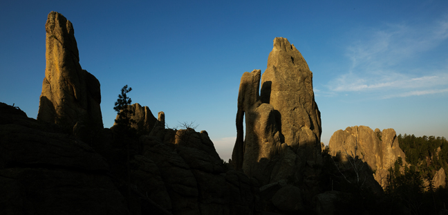
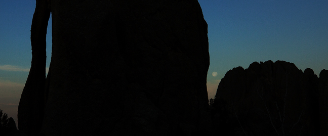
July 2017: Full Moon Setting, Dawn, Needles Eye Arch, Custer State Park, ND
The Dakota Territory, the northwest corner of the land acquired from France in the Louisiana Purchase was originally much larger than the area of the two present Dakotas. When originally created in 1861, it included much of present-day Montana and Wyoming, part of Nebraska as well as all of the present-day Dakotas. By 1868, the Territory had been reduced to the present boundaries of the current Dakotas.
It was divided just below the 46th parallel when the two states entered the Union in 1889 as a ploy by Republicans to add two additional Senators, although it would have been more logical to create East and West Dakota as both halves of the former territory are divided by the Missouri River, a natural border, which enters in the northwest, and leaves it in the southeast.
Our exploration of "West Dakota" included three sites: Custer State Park, Wind Cave National Park and Theodore Roosevelt National Park.
Custer State Park is one of the most impressive state parks in the country. It has four beautiful lodges, a variety of camp sites, historic sites, stunning scenic drives, trout fishing in four mountainous lakes, challenging hikes, a variety of wildlife, including a herd of 1,300 bison, and an iconic natural arch.
Less than 20 miles to the south of Custer State Park is Wind Cave National Park, the eighth national park established in the United States, protected since 1903. Long regarded as sacred by Native Americans, cave exploration did not begin until 1881, when two brothers, Jesse and Tom Bingham, noticed the entrance. They heard a loud whistling noise, which led them to a small hole in the ground, the cave's only natural opening.
As of 2017, 143.16 miles of passages have been mapped in Wind Cave, making it the third largest cave in the United States and the seventh longest cave in the world. In no other known cave is boxwork so well formed and abundant as in Wind Cave. Boxwork is a formation made of thin blades of calcite that project from cave walls and ceilings, forming a honeycomb pattern.
The cave also features small, knobby growths of calcite on the walls called cave popcorn. Popcorn commonly forms where water seeps out of the limestone wall and precipitates calcite; or, when water drips from the walls or ceilings of the cave and the water splashes on the floor or on ledges along the walls. This splashing action causes loss of carbon dioxide and the subsequent precipitation of calcite.
Our final stop was at Theodore Roosevelt National Park, a 70,446 acre park established in honor of President Theodore Roosevelt that is divided into three areas: the Elkhorn Ranch Unit, the South Unit and the North Unit. Roosevelt came to the Dakotas in 1883 to hunt bison. He later owned ranches in the area. The Park was established in 1978 after having been designated the Roosevelt Recreation Demonstration Area in 1935, the Theodore Roosevelt National Wildlife Refuge in 1946 and the Theodore Roosevelt National Memorial Park in 1947.
©Rich Beckman
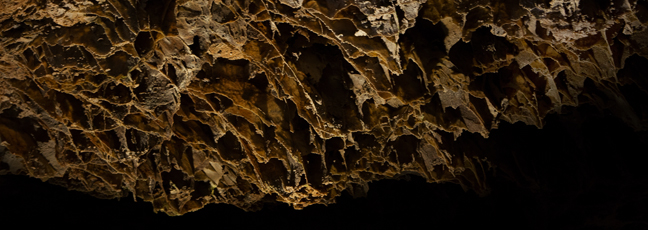
July 2017: Boxwork, Wind Cave National Park, SD
The Dakota Territory, the northwest corner of the land acquired from France in the Louisiana Purchase was originally much larger than the area of the two present Dakotas. When originally created in 1861, it included much of present-day Montana and Wyoming, part of Nebraska as well as all of the present-day Dakotas. By 1868, the Territory had been reduced to the present boundaries of the current Dakotas.
It was divided just below the 46th parallel when the two states entered the Union in 1889 as a ploy by Republicans to add two additional Senators, although it would have been more logical to create East and West Dakota as both halves of the former territory are divided by the Missouri River, a natural border, which enters in the northwest, and leaves it in the southeast.
Our exploration of "West Dakota" included three sites: Custer State Park, Wind Cave National Park and Theodore Roosevelt National Park.
Custer State Park is one of the most impressive state parks in the country. It has four beautiful lodges, a variety of camp sites, historic sites, stunning scenic drives, trout fishing in four mountainous lakes, challenging hikes, a variety of wildlife, including a herd of 1,300 bison, and an iconic natural arch.
Less than 20 miles to the south of Custer State Park is Wind Cave National Park, the eighth national park established in the United States, protected since 1903. Long regarded as sacred by Native Americans, cave exploration did not begin until 1881, when two brothers, Jesse and Tom Bingham, noticed the entrance. They heard a loud whistling noise, which led them to a small hole in the ground, the cave's only natural opening.
As of 2017, 143.16 miles of passages have been mapped in Wind Cave, making it the third largest cave in the United States and the seventh longest cave in the world. In no other known cave is boxwork so well formed and abundant as in Wind Cave. Boxwork is a formation made of thin blades of calcite that project from cave walls and ceilings, forming a honeycomb pattern.
The cave also features small, knobby growths of calcite on the walls called cave popcorn. Popcorn commonly forms where water seeps out of the limestone wall and precipitates calcite; or, when water drips from the walls or ceilings of the cave and the water splashes on the floor or on ledges along the walls. This splashing action causes loss of carbon dioxide and the subsequent precipitation of calcite.
Our final stop was at Theodore Roosevelt National Park, a 70,446 acre park established in honor of President Theodore Roosevelt that is divided into three areas: the Elkhorn Ranch Unit, the South Unit and the North Unit. Roosevelt came to the Dakotas in 1883 to hunt bison. He later owned ranches in the area. The Park was established in 1978 after having been designated the Roosevelt Recreation Demonstration Area in 1935, the Theodore Roosevelt National Wildlife Refuge in 1946 and the Theodore Roosevelt National Memorial Park in 1947.
©Rich Beckman
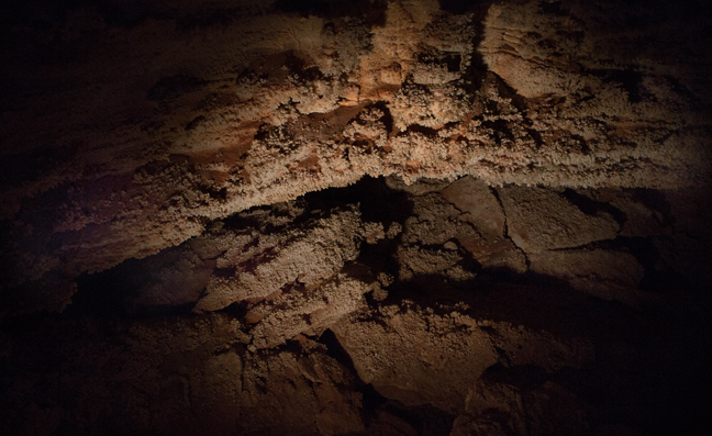
July 2017: Cave Popcorn, Wind Cave National Park, SD
The Dakota Territory, the northwest corner of the land acquired from France in the Louisiana Purchase was originally much larger than the area of the two present Dakotas. When originally created in 1861, it included much of present-day Montana and Wyoming, part of Nebraska as well as all of the present-day Dakotas. By 1868, the Territory had been reduced to the present boundaries of the current Dakotas.
It was divided just below the 46th parallel when the two states entered the Union in 1889 as a ploy by Republicans to add two additional Senators, although it would have been more logical to create East and West Dakota as both halves of the former territory are divided by the Missouri River, a natural border, which enters in the northwest, and leaves it in the southeast.
Our exploration of "West Dakota" included three sites: Custer State Park, Wind Cave National Park and Theodore Roosevelt National Park.
Custer State Park is one of the most impressive state parks in the country. It has four beautiful lodges, a variety of camp sites, historic sites, stunning scenic drives, trout fishing in four mountainous lakes, challenging hikes, a variety of wildlife, including a herd of 1,300 bison, and an iconic natural arch.
Less than 20 miles to the south of Custer State Park is Wind Cave National Park, the eighth national park established in the United States, protected since 1903. Long regarded as sacred by Native Americans, cave exploration did not begin until 1881, when two brothers, Jesse and Tom Bingham, noticed the entrance. They heard a loud whistling noise, which led them to a small hole in the ground, the cave's only natural opening.
As of 2017, 143.16 miles of passages have been mapped in Wind Cave, making it the third largest cave in the United States and the seventh longest cave in the world. In no other known cave is boxwork so well formed and abundant as in Wind Cave. Boxwork is a formation made of thin blades of calcite that project from cave walls and ceilings, forming a honeycomb pattern.
The cave also features small, knobby growths of calcite on the walls called cave popcorn. Popcorn commonly forms where water seeps out of the limestone wall and precipitates calcite; or, when water drips from the walls or ceilings of the cave and the water splashes on the floor or on ledges along the walls. This splashing action causes loss of carbon dioxide and the subsequent precipitation of calcite.
Our final stop was at Theodore Roosevelt National Park, a 70,446 acre park established in honor of President Theodore Roosevelt that is divided into three areas: the Elkhorn Ranch Unit, the South Unit and the North Unit. Roosevelt came to the Dakotas in 1883 to hunt bison. He later owned ranches in the area. The Park was established in 1978 after having been designated the Roosevelt Recreation Demonstration Area in 1935, the Theodore Roosevelt National Wildlife Refuge in 1946 and the Theodore Roosevelt National Memorial Park in 1947.
©Rich Beckman
July 2017: Landscape, South Unit, Theodore Roosevelt National Park, ND
The Dakota Territory, the northwest corner of the land acquired from France in the Louisiana Purchase was originally much larger than the area of the two present Dakotas. When originally created in 1861, it included much of present-day Montana and Wyoming, part of Nebraska as well as all of the present-day Dakotas. By 1868, the Territory had been reduced to the present boundaries of the current Dakotas.
It was divided just below the 46th parallel when the two states entered the Union in 1889 as a ploy by Republicans to add two additional Senators, although it would have been more logical to create East and West Dakota as both halves of the former territory are divided by the Missouri River, a natural border, which enters in the northwest, and leaves it in the southeast.
Our exploration of "West Dakota" included three sites: Custer State Park, Wind Cave National Park and Theodore Roosevelt National Park.
Custer State Park is one of the most impressive state parks in the country. It has four beautiful lodges, a variety of camp sites, historic sites, stunning scenic drives, trout fishing in four mountainous lakes, challenging hikes, a variety of wildlife, including a herd of 1,300 bison, and an iconic natural arch.
Less than 20 miles to the south of Custer State Park is Wind Cave National Park, the eighth national park established in the United States, protected since 1903. Long regarded as sacred by Native Americans, cave exploration did not begin until 1881, when two brothers, Jesse and Tom Bingham, noticed the entrance. They heard a loud whistling noise, which led them to a small hole in the ground, the cave's only natural opening.
As of 2017, 143.16 miles of passages have been mapped in Wind Cave, making it the third largest cave in the United States and the seventh longest cave in the world. In no other known cave is boxwork so well formed and abundant as in Wind Cave. Boxwork is a formation made of thin blades of calcite that project from cave walls and ceilings, forming a honeycomb pattern.
The cave also features small, knobby growths of calcite on the walls called cave popcorn. Popcorn commonly forms where water seeps out of the limestone wall and precipitates calcite; or, when water drips from the walls or ceilings of the cave and the water splashes on the floor or on ledges along the walls. This splashing action causes loss of carbon dioxide and the subsequent precipitation of calcite.
Our final stop was at Theodore Roosevelt National Park, a 70,446 acre park established in honor of President Theodore Roosevelt that is divided into noncontiguous three areas: the Elkhorn Ranch Unit, the South Unit and the North Unit. Roosevelt came to the Dakotas in 1883 to hunt bison. He later owned ranches in the area. The Park was established in 1978 after having been designated the Roosevelt Recreation Demonstration Area in 1935, the Theodore Roosevelt National Wildlife Refuge in 1946 and the Theodore Roosevelt National Memorial Park in 1947.
©Rich Beckman
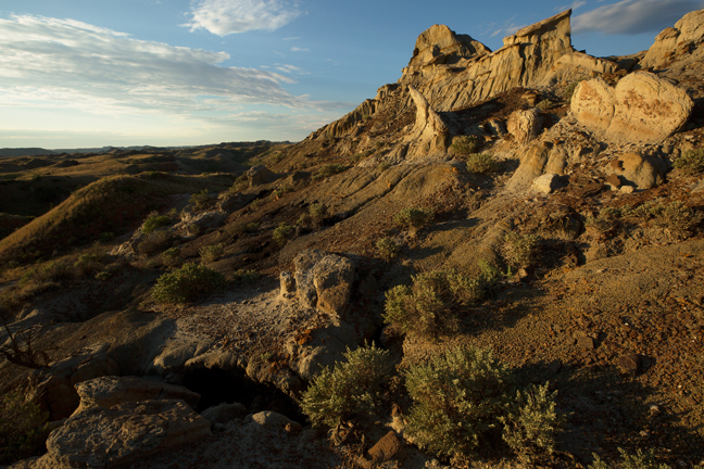
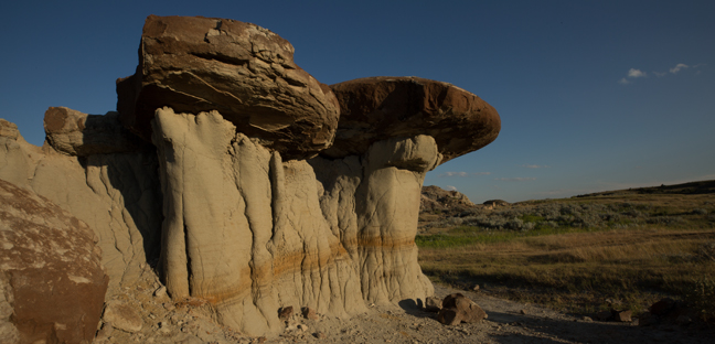
July 2017: Unnamed Hoodoo Formation, South Unit, Theodore Roosevelt National Park, ND
The Dakota Territory, the northwest corner of the land acquired from France in the Louisiana Purchase was originally much larger than the area of the two present Dakotas. When originally created in 1861, it included much of present-day Montana and Wyoming, part of Nebraska as well as all of the present-day Dakotas. By 1868, the Territory had been reduced to the present boundaries of the current Dakotas.
It was divided just below the 46th parallel when the two states entered the Union in 1889 as a ploy by Republicans to add two additional Senators, although it would have been more logical to create East and West Dakota as both halves of the former territory are divided by the Missouri River, a natural border, which enters in the northwest, and leaves it in the southeast.
Our exploration of "West Dakota" included three sites: Custer State Park, Wind Cave National Park and Theodore Roosevelt National Park.
Custer State Park is one of the most impressive state parks in the country. It has four beautiful lodges, a variety of camp sites, historic sites, stunning scenic drives, trout fishing in four mountainous lakes, challenging hikes, a variety of wildlife, including a herd of 1,300 bison, and an iconic natural arch.
Less than 20 miles to the south of Custer State Park is Wind Cave National Park, the eighth national park established in the United States, protected since 1903. Long regarded as sacred by Native Americans, cave exploration did not begin until 1881, when two brothers, Jesse and Tom Bingham, noticed the entrance. They heard a loud whistling noise, which led them to a small hole in the ground, the cave's only natural opening.
As of 2017, 143.16 miles of passages have been mapped in Wind Cave, making it the third largest cave in the United States and the seventh longest cave in the world. In no other known cave is boxwork so well formed and abundant as in Wind Cave. Boxwork is a formation made of thin blades of calcite that project from cave walls and ceilings, forming a honeycomb pattern.
The cave also features small, knobby growths of calcite on the walls called cave popcorn. Popcorn commonly forms where water seeps out of the limestone wall and precipitates calcite; or, when water drips from the walls or ceilings of the cave and the water splashes on the floor or on ledges along the walls. This splashing action causes loss of carbon dioxide and the subsequent precipitation of calcite.
Our final stop was at Theodore Roosevelt National Park, a 70,446 acre park established in honor of President Theodore Roosevelt that is divided into noncontiguous three areas: the Elkhorn Ranch Unit, the South Unit and the North Unit. Roosevelt came to the Dakotas in 1883 to hunt bison. He later owned ranches in the area. The Park was established in 1978 after having been designated the Roosevelt Recreation Demonstration Area in 1935, the Theodore Roosevelt National Wildlife Refuge in 1946 and the Theodore Roosevelt National Memorial Park in 1947.
©Rich Beckman

July 2017: Black-tailed Prairie Dog, South Unit, Theodore Roosevelt National Park, ND
The Dakota Territory, the northwest corner of the land acquired from France in the Louisiana Purchase was originally much larger than the area of the two present Dakotas. When originally created in 1861, it included much of present-day Montana and Wyoming, part of Nebraska as well as all of the present-day Dakotas. By 1868, the Territory had been reduced to the present boundaries of the current Dakotas.
It was divided just below the 46th parallel when the two states entered the Union in 1889 as a ploy by Republicans to add two additional Senators, although it would have been more logical to create East and West Dakota as both halves of the former territory are divided by the Missouri River, a natural border, which enters in the northwest, and leaves it in the southeast.
Our exploration of "West Dakota" included three sites: Custer State Park, Wind Cave National Park and Theodore Roosevelt National Park.
Custer State Park is one of the most impressive state parks in the country. It has four beautiful lodges, a variety of camp sites, historic sites, stunning scenic drives, trout fishing in four mountainous lakes, challenging hikes, a variety of wildlife, including a herd of 1,300 bison, and an iconic natural arch.
Less than 20 miles to the south of Custer State Park is Wind Cave National Park, the eighth national park established in the United States, protected since 1903. Long regarded as sacred by Native Americans, cave exploration did not begin until 1881, when two brothers, Jesse and Tom Bingham, noticed the entrance. They heard a loud whistling noise, which led them to a small hole in the ground, the cave's only natural opening.
As of 2017, 143.16 miles of passages have been mapped in Wind Cave, making it the third largest cave in the United States and the seventh longest cave in the world. In no other known cave is boxwork so well formed and abundant as in Wind Cave. Boxwork is a formation made of thin blades of calcite that project from cave walls and ceilings, forming a honeycomb pattern.
The cave also features small, knobby growths of calcite on the walls called cave popcorn. Popcorn commonly forms where water seeps out of the limestone wall and precipitates calcite; or, when water drips from the walls or ceilings of the cave and the water splashes on the floor or on ledges along the walls. This splashing action causes loss of carbon dioxide and the subsequent precipitation of calcite.
Our final stop was at Theodore Roosevelt National Park, a 70,446 acre park established in honor of President Theodore Roosevelt that is divided into noncontiguous three areas: the Elkhorn Ranch Unit, the South Unit and the North Unit. Roosevelt came to the Dakotas in 1883 to hunt bison. He later owned ranches in the area. The Park was established in 1978 after having been designated the Roosevelt Recreation Demonstration Area in 1935, the Theodore Roosevelt National Wildlife Refuge in 1946 and the Theodore Roosevelt National Memorial Park in 1947.
©Rich Beckman
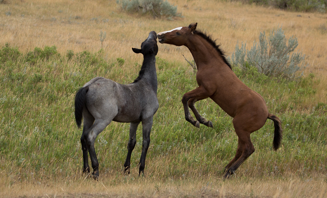
July 2017: Feral Horses, South Unit, Theodore Roosevelt National Park, ND
The Dakota Territory, the northwest corner of the land acquired from France in the Louisiana Purchase was originally much larger than the area of the two present Dakotas. When originally created in 1861, it included much of present-day Montana and Wyoming, part of Nebraska as well as all of the present-day Dakotas. By 1868, the Territory had been reduced to the present boundaries of the current Dakotas.
It was divided just below the 46th parallel when the two states entered the Union in 1889 as a ploy by Republicans to add two additional Senators, although it would have been more logical to create East and West Dakota as both halves of the former territory are divided by the Missouri River, a natural border, which enters in the northwest, and leaves it in the southeast.
Our exploration of "West Dakota" included three sites: Custer State Park, Wind Cave National Park and Theodore Roosevelt National Park.
Custer State Park is one of the most impressive state parks in the country. It has four beautiful lodges, a variety of camp sites, historic sites, stunning scenic drives, trout fishing in four mountainous lakes, challenging hikes, a variety of wildlife, including a herd of 1,300 bison, and an iconic natural arch.
Less than 20 miles to the south of Custer State Park is Wind Cave National Park, the eighth national park established in the United States, protected since 1903. Long regarded as sacred by Native Americans, cave exploration did not begin until 1881, when two brothers, Jesse and Tom Bingham, noticed the entrance. They heard a loud whistling noise, which led them to a small hole in the ground, the cave's only natural opening.
As of 2017, 143.16 miles of passages have been mapped in Wind Cave, making it the third largest cave in the United States and the seventh longest cave in the world. In no other known cave is boxwork so well formed and abundant as in Wind Cave. Boxwork is a formation made of thin blades of calcite that project from cave walls and ceilings, forming a honeycomb pattern.
The cave also features small, knobby growths of calcite on the walls called cave popcorn. Popcorn commonly forms where water seeps out of the limestone wall and precipitates calcite; or, when water drips from the walls or ceilings of the cave and the water splashes on the floor or on ledges along the walls. This splashing action causes loss of carbon dioxide and the subsequent precipitation of calcite.
Our final stop was at Theodore Roosevelt National Park, a 70,446 acre park established in honor of President Theodore Roosevelt that is divided into noncontiguous three areas: the Elkhorn Ranch Unit, the South Unit and the North Unit. Roosevelt came to the Dakotas in 1883 to hunt bison. He later owned ranches in the area. The Park was established in 1978 after having been designated the Roosevelt Recreation Demonstration Area in 1935, the Theodore Roosevelt National Wildlife Refuge in 1946 and the Theodore Roosevelt National Memorial Park in 1947.
©Rich Beckman
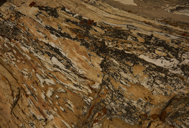
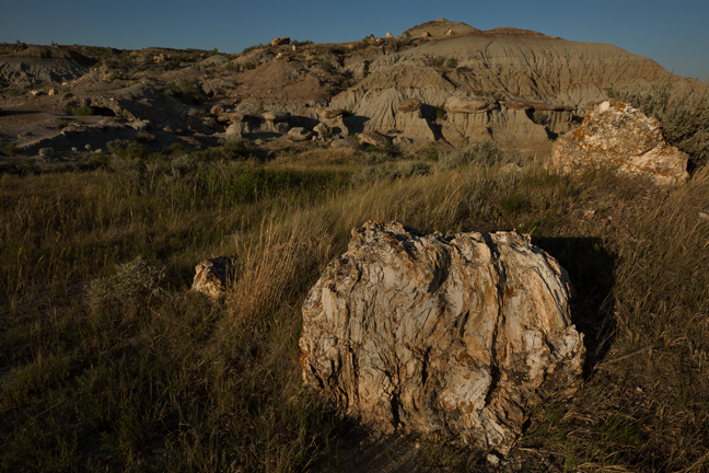
July 2017: Petrified Wood Detail, South Petrified Forest Trail, South Unit, Theodore Roosevelt National Park, ND
The Dakota Territory, the northwest corner of the land acquired from France in the Louisiana Purchase was originally much larger than the area of the two present Dakotas. When originally created in 1861, it included much of present-day Montana and Wyoming, part of Nebraska as well as all of the present-day Dakotas. By 1868, the Territory had been reduced to the present boundaries of the current Dakotas.
It was divided just below the 46th parallel when the two states entered the Union in 1889 as a ploy by Republicans to add two additional Senators, although it would have been more logical to create East and West Dakota as both halves of the former territory are divided by the Missouri River, a natural border, which enters in the northwest, and leaves it in the southeast.
Our exploration of "West Dakota" included three sites: Custer State Park, Wind Cave National Park and Theodore Roosevelt National Park.
Custer State Park is one of the most impressive state parks in the country. It has four beautiful lodges, a variety of camp sites, historic sites, stunning scenic drives, trout fishing in four mountainous lakes, challenging hikes, a variety of wildlife, including a herd of 1,300 bison, and an iconic natural arch.
Less than 20 miles to the south of Custer State Park is Wind Cave National Park, the eighth national park established in the United States, protected since 1903. Long regarded as sacred by Native Americans, cave exploration did not begin until 1881, when two brothers, Jesse and Tom Bingham, noticed the entrance. They heard a loud whistling noise, which led them to a small hole in the ground, the cave's only natural opening.
As of 2017, 143.16 miles of passages have been mapped in Wind Cave, making it the third largest cave in the United States and the seventh longest cave in the world. In no other known cave is boxwork so well formed and abundant as in Wind Cave. Boxwork is a formation made of thin blades of calcite that project from cave walls and ceilings, forming a honeycomb pattern.
The cave also features small, knobby growths of calcite on the walls called cave popcorn. Popcorn commonly forms where water seeps out of the limestone wall and precipitates calcite; or, when water drips from the walls or ceilings of the cave and the water splashes on the floor or on ledges along the walls. This splashing action causes loss of carbon dioxide and the subsequent precipitation of calcite.
Our final stop was at Theodore Roosevelt National Park, a 70,446 acre park established in honor of President Theodore Roosevelt that is divided into noncontiguous three areas: the Elkhorn Ranch Unit, the South Unit and the North Unit. Roosevelt came to the Dakotas in 1883 to hunt bison. He later owned ranches in the area. The Park was established in 1978 after having been designated the Roosevelt Recreation Demonstration Area in 1935, the Theodore Roosevelt National Wildlife Refuge in 1946 and the Theodore Roosevelt National Memorial Park in 1947.
©Rich Beckman
July 2017: Petrified Wood and Hoodoos, North Petrified Forest Trail, South Unit, Theodore Roosevelt National Park, ND
The Dakota Territory, the northwest corner of the land acquired from France in the Louisiana Purchase was originally much larger than the area of the two present Dakotas. When originally created in 1861, it included much of present-day Montana and Wyoming, part of Nebraska as well as all of the present-day Dakotas. By 1868, the Territory had been reduced to the present boundaries of the current Dakotas.
It was divided just below the 46th parallel when the two states entered the Union in 1889 as a ploy by Republicans to add two additional Senators, although it would have been more logical to create East and West Dakota as both halves of the former territory are divided by the Missouri River, a natural border, which enters in the northwest, and leaves it in the southeast.
Our exploration of "West Dakota" included three sites: Custer State Park, Wind Cave National Park and Theodore Roosevelt National Park.
Custer State Park is one of the most impressive state parks in the country. It has four beautiful lodges, a variety of camp sites, historic sites, stunning scenic drives, trout fishing in four mountainous lakes, challenging hikes, a variety of wildlife, including a herd of 1,300 bison, and an iconic natural arch.
Less than 20 miles to the south of Custer State Park is Wind Cave National Park, the eighth national park established in the United States, protected since 1903. Long regarded as sacred by Native Americans, cave exploration did not begin until 1881, when two brothers, Jesse and Tom Bingham, noticed the entrance. They heard a loud whistling noise, which led them to a small hole in the ground, the cave's only natural opening.
As of 2017, 143.16 miles of passages have been mapped in Wind Cave, making it the third largest cave in the United States and the seventh longest cave in the world. In no other known cave is boxwork so well formed and abundant as in Wind Cave. Boxwork is a formation made of thin blades of calcite that project from cave walls and ceilings, forming a honeycomb pattern.
The cave also features small, knobby growths of calcite on the walls called cave popcorn. Popcorn commonly forms where water seeps out of the limestone wall and precipitates calcite; or, when water drips from the walls or ceilings of the cave and the water splashes on the floor or on ledges along the walls. This splashing action causes loss of carbon dioxide and the subsequent precipitation of calcite.
Our final stop was at Theodore Roosevelt National Park, a 70,446 acre park established in honor of President Theodore Roosevelt that is divided into noncontiguous three areas: the Elkhorn Ranch Unit, the South Unit and the North Unit. Roosevelt came to the Dakotas in 1883 to hunt bison. He later owned ranches in the area. The Park was established in 1978 after having been designated the Roosevelt Recreation Demonstration Area in 1935, the Theodore Roosevelt National Wildlife Refuge in 1946 and the Theodore Roosevelt National Memorial Park in 1947.
©Rich Beckman
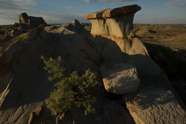
July 2017: Hoodoos, North Petrified Forest Trail, South Unit, Theodore Roosevelt National Park, ND
The Dakota Territory, the northwest corner of the land acquired from France in the Louisiana Purchase was originally much larger than the area of the two present Dakotas. When originally created in 1861, it included much of present-day Montana and Wyoming, part of Nebraska as well as all of the present-day Dakotas. By 1868, the Territory had been reduced to the present boundaries of the current Dakotas.
It was divided just below the 46th parallel when the two states entered the Union in 1889 as a ploy by Republicans to add two additional Senators, although it would have been more logical to create East and West Dakota as both halves of the former territory are divided by the Missouri River, a natural border, which enters in the northwest, and leaves it in the southeast.
Our exploration of "West Dakota" included three sites: Custer State Park, Wind Cave National Park and Theodore Roosevelt National Park.
Custer State Park is one of the most impressive state parks in the country. It has four beautiful lodges, a variety of camp sites, historic sites, stunning scenic drives, trout fishing in four mountainous lakes, challenging hikes, a variety of wildlife, including a herd of 1,300 bison, and an iconic natural arch.
Less than 20 miles to the south of Custer State Park is Wind Cave National Park, the eighth national park established in the United States, protected since 1903. Long regarded as sacred by Native Americans, cave exploration did not begin until 1881, when two brothers, Jesse and Tom Bingham, noticed the entrance. They heard a loud whistling noise, which led them to a small hole in the ground, the cave's only natural opening.
As of 2017, 143.16 miles of passages have been mapped in Wind Cave, making it the third largest cave in the United States and the seventh longest cave in the world. In no other known cave is boxwork so well formed and abundant as in Wind Cave. Boxwork is a formation made of thin blades of calcite that project from cave walls and ceilings, forming a honeycomb pattern.
The cave also features small, knobby growths of calcite on the walls called cave popcorn. Popcorn commonly forms where water seeps out of the limestone wall and precipitates calcite; or, when water drips from the walls or ceilings of the cave and the water splashes on the floor or on ledges along the walls. This splashing action causes loss of carbon dioxide and the subsequent precipitation of calcite.
Our final stop was at Theodore Roosevelt National Park, a 70,446 acre park established in honor of President Theodore Roosevelt that is divided into noncontiguous three areas: the Elkhorn Ranch Unit, the South Unit and the North Unit. Roosevelt came to the Dakotas in 1883 to hunt bison. He later owned ranches in the area. The Park was established in 1978 after having been designated the Roosevelt Recreation Demonstration Area in 1935, the Theodore Roosevelt National Wildlife Refuge in 1946 and the Theodore Roosevelt National Memorial Park in 1947.
©Rich Beckman
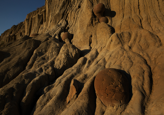
July 2017: Cannon Ball Concretions, North Unit, Theodore Roosevelt National Park, ND
The Dakota Territory, the northwest corner of the land acquired from France in the Louisiana Purchase was originally much larger than the area of the two present Dakotas. When originally created in 1861, it included much of present-day Montana and Wyoming, part of Nebraska as well as all of the present-day Dakotas. By 1868, the Territory had been reduced to the present boundaries of the current Dakotas.
It was divided just below the 46th parallel when the two states entered the Union in 1889 as a ploy by Republicans to add two additional Senators, although it would have been more logical to create East and West Dakota as both halves of the former territory are divided by the Missouri River, a natural border, which enters in the northwest, and leaves it in the southeast.
Our exploration of "West Dakota" included three sites: Custer State Park, Wind Cave National Park and Theodore Roosevelt National Park.
Custer State Park is one of the most impressive state parks in the country. It has four beautiful lodges, a variety of camp sites, historic sites, stunning scenic drives, trout fishing in four mountainous lakes, challenging hikes, a variety of wildlife, including a herd of 1,300 bison, and an iconic natural arch.
Less than 20 miles to the south of Custer State Park is Wind Cave National Park, the eighth national park established in the United States, protected since 1903. Long regarded as sacred by Native Americans, cave exploration did not begin until 1881, when two brothers, Jesse and Tom Bingham, noticed the entrance. They heard a loud whistling noise, which led them to a small hole in the ground, the cave's only natural opening.
As of 2017, 143.16 miles of passages have been mapped in Wind Cave, making it the third largest cave in the United States and the seventh longest cave in the world. In no other known cave is boxwork so well formed and abundant as in Wind Cave. Boxwork is a formation made of thin blades of calcite that project from cave walls and ceilings, forming a honeycomb pattern.
The cave also features small, knobby growths of calcite on the walls called cave popcorn. Popcorn commonly forms where water seeps out of the limestone wall and precipitates calcite; or, when water drips from the walls or ceilings of the cave and the water splashes on the floor or on ledges along the walls. This splashing action causes loss of carbon dioxide and the subsequent precipitation of calcite.
Our final stop was at Theodore Roosevelt National Park, a 70,446 acre park established in honor of President Theodore Roosevelt that is divided into noncontiguous three areas: the Elkhorn Ranch Unit, the South Unit and the North Unit. Roosevelt came to the Dakotas in 1883 to hunt bison. He later owned ranches in the area. The Park was established in 1978 after having been designated the Roosevelt Recreation Demonstration Area in 1935, the Theodore Roosevelt National Wildlife Refuge in 1946 and the Theodore Roosevelt National Memorial Park in 1947.
©Rich Beckman
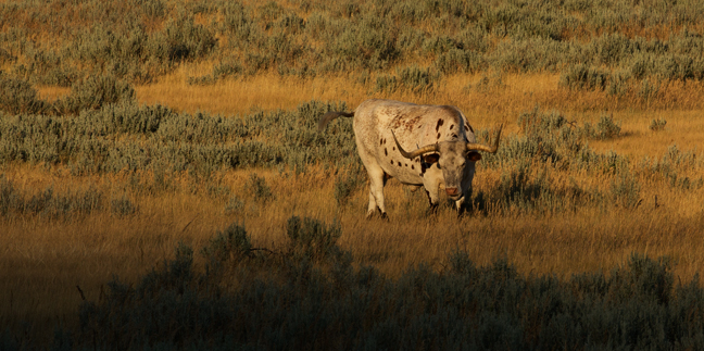
July 2017: Longhorn Steer, North Unit, Theodore Roosevelt National Park, ND
The Dakota Territory, the northwest corner of the land acquired from France in the Louisiana Purchase was originally much larger than the area of the two present Dakotas. When originally created in 1861, it included much of present-day Montana and Wyoming, part of Nebraska as well as all of the present-day Dakotas. By 1868, the Territory had been reduced to the present boundaries of the current Dakotas.
It was divided just below the 46th parallel when the two states entered the Union in 1889 as a ploy by Republicans to add two additional Senators, although it would have been more logical to create East and West Dakota as both halves of the former territory are divided by the Missouri River, a natural border, which enters in the northwest, and leaves it in the southeast.
Our exploration of "West Dakota" included three sites: Custer State Park, Wind Cave National Park and Theodore Roosevelt National Park.
Custer State Park is one of the most impressive state parks in the country. It has four beautiful lodges, a variety of camp sites, historic sites, stunning scenic drives, trout fishing in four mountainous lakes, challenging hikes, a variety of wildlife, including a herd of 1,300 bison, and an iconic natural arch.
Less than 20 miles to the south of Custer State Park is Wind Cave National Park, the eighth national park established in the United States, protected since 1903. Long regarded as sacred by Native Americans, cave exploration did not begin until 1881, when two brothers, Jesse and Tom Bingham, noticed the entrance. They heard a loud whistling noise, which led them to a small hole in the ground, the cave's only natural opening.
As of 2017, 143.16 miles of passages have been mapped in Wind Cave, making it the third largest cave in the United States and the seventh longest cave in the world. In no other known cave is boxwork so well formed and abundant as in Wind Cave. Boxwork is a formation made of thin blades of calcite that project from cave walls and ceilings, forming a honeycomb pattern.
The cave also features small, knobby growths of calcite on the walls called cave popcorn. Popcorn commonly forms where water seeps out of the limestone wall and precipitates calcite; or, when water drips from the walls or ceilings of the cave and the water splashes on the floor or on ledges along the walls. This splashing action causes loss of carbon dioxide and the subsequent precipitation of calcite.
Our final stop was at Theodore Roosevelt National Park, a 70,446 acre park established in honor of President Theodore Roosevelt that is divided into noncontiguous three areas: the Elkhorn Ranch Unit, the South Unit and the North Unit. Roosevelt came to the Dakotas in 1883 to hunt bison. He later owned ranches in the area. The Park was established in 1978 after having been designated the Roosevelt Recreation Demonstration Area in 1935, the Theodore Roosevelt National Wildlife Refuge in 1946 and the Theodore Roosevelt National Memorial Park in 1947.
©Rich Beckman
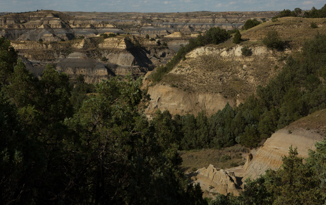
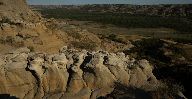
July 2017: Caprock Coulee Trail, North Unit, Theodore Roosevelt National Park, ND
The Dakota Territory, the northwest corner of the land acquired from France in the Louisiana Purchase was originally much larger than the area of the two present Dakotas. When originally created in 1861, it included much of present-day Montana and Wyoming, part of Nebraska as well as all of the present-day Dakotas. By 1868, the Territory had been reduced to the present boundaries of the current Dakotas.
It was divided just below the 46th parallel when the two states entered the Union in 1889 as a ploy by Republicans to add two additional Senators, although it would have been more logical to create East and West Dakota as both halves of the former territory are divided by the Missouri River, a natural border, which enters in the northwest, and leaves it in the southeast.
Our exploration of "West Dakota" included three sites: Custer State Park, Wind Cave National Park and Theodore Roosevelt National Park.
Custer State Park is one of the most impressive state parks in the country. It has four beautiful lodges, a variety of camp sites, historic sites, stunning scenic drives, trout fishing in four mountainous lakes, challenging hikes, a variety of wildlife, including a herd of 1,300 bison, and an iconic natural arch.
Less than 20 miles to the south of Custer State Park is Wind Cave National Park, the eighth national park established in the United States, protected since 1903. Long regarded as sacred by Native Americans, cave exploration did not begin until 1881, when two brothers, Jesse and Tom Bingham, noticed the entrance. They heard a loud whistling noise, which led them to a small hole in the ground, the cave's only natural opening.
As of 2017, 143.16 miles of passages have been mapped in Wind Cave, making it the third largest cave in the United States and the seventh longest cave in the world. In no other known cave is boxwork so well formed and abundant as in Wind Cave. Boxwork is a formation made of thin blades of calcite that project from cave walls and ceilings, forming a honeycomb pattern.
The cave also features small, knobby growths of calcite on the walls called cave popcorn. Popcorn commonly forms where water seeps out of the limestone wall and precipitates calcite; or, when water drips from the walls or ceilings of the cave and the water splashes on the floor or on ledges along the walls. This splashing action causes loss of carbon dioxide and the subsequent precipitation of calcite.
Our final stop was at Theodore Roosevelt National Park, a 70,446 acre park established in honor of President Theodore Roosevelt that is divided into noncontiguous three areas: the Elkhorn Ranch Unit, the South Unit and the North Unit. Roosevelt came to the Dakotas in 1883 to hunt bison. He later owned ranches in the area. The Park was established in 1978 after having been designated the Roosevelt Recreation Demonstration Area in 1935, the Theodore Roosevelt National Wildlife Refuge in 1946 and the Theodore Roosevelt National Memorial Park in 1947.
©Rich Beckman
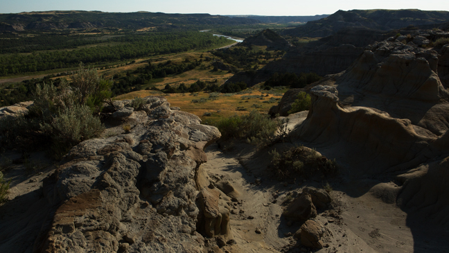
July 2017: River Bend, Caprock Coulee Trail, North Unit, Theodore Roosevelt National Park, ND
The Dakota Territory, the northwest corner of the land acquired from France in the Louisiana Purchase was originally much larger than the area of the two present Dakotas. When originally created in 1861, it included much of present-day Montana and Wyoming, part of Nebraska as well as all of the present-day Dakotas. By 1868, the Territory had been reduced to the present boundaries of the current Dakotas.
It was divided just below the 46th parallel when the two states entered the Union in 1889 as a ploy by Republicans to add two additional Senators, although it would have been more logical to create East and West Dakota as both halves of the former territory are divided by the Missouri River, a natural border, which enters in the northwest, and leaves it in the southeast.
Our exploration of "West Dakota" included three sites: Custer State Park, Wind Cave National Park and Theodore Roosevelt National Park.
Custer State Park is one of the most impressive state parks in the country. It has four beautiful lodges, a variety of camp sites, historic sites, stunning scenic drives, trout fishing in four mountainous lakes, challenging hikes, a variety of wildlife, including a herd of 1,300 bison, and an iconic natural arch.
Less than 20 miles to the south of Custer State Park is Wind Cave National Park, the eighth national park established in the United States, protected since 1903. Long regarded as sacred by Native Americans, cave exploration did not begin until 1881, when two brothers, Jesse and Tom Bingham, noticed the entrance. They heard a loud whistling noise, which led them to a small hole in the ground, the cave's only natural opening.
As of 2017, 143.16 miles of passages have been mapped in Wind Cave, making it the third largest cave in the United States and the seventh longest cave in the world. In no other known cave is boxwork so well formed and abundant as in Wind Cave. Boxwork is a formation made of thin blades of calcite that project from cave walls and ceilings, forming a honeycomb pattern.
The cave also features small, knobby growths of calcite on the walls called cave popcorn. Popcorn commonly forms where water seeps out of the limestone wall and precipitates calcite; or, when water drips from the walls or ceilings of the cave and the water splashes on the floor or on ledges along the walls. This splashing action causes loss of carbon dioxide and the subsequent precipitation of calcite.
Our final stop was at Theodore Roosevelt National Park, a 70,446 acre park established in honor of President Theodore Roosevelt that is divided into noncontiguous three areas: the Elkhorn Ranch Unit, the South Unit and the North Unit. Roosevelt came to the Dakotas in 1883 to hunt bison. He later owned ranches in the area. The Park was established in 1978 after having been designated the Roosevelt Recreation Demonstration Area in 1935, the Theodore Roosevelt National Wildlife Refuge in 1946 and the Theodore Roosevelt National Memorial Park in 1947.
©Rich Beckman