
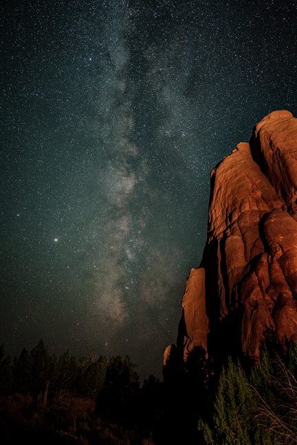
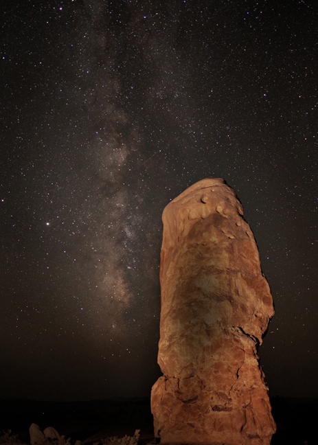
Milky Way, Kodachrome Basin State Park, UT, September 2020
Around the turn of the 20th century, cattlemen from Cannonville and Henrieville used the basin as a winter pasture. In 1948 the National Geographic Society explored and photographed the area for a story and named the area Kodachrome Flat, after the brand of Kodak film they used. When the area was designated as a state park in 1962, the name was changed to Chimney Rock State Park. It was renamed Kodachrome Basin a few years later after receiving permission from Kodak.
©Rich Beckman
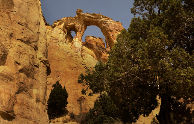
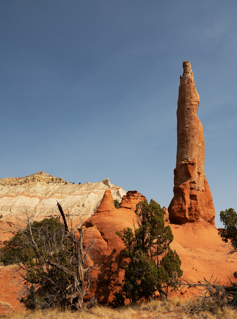
Grosvenor Arch, Cottonwood Canyon Road, UT, September 2020
Ten miles past the BLM Big Water, Utah Visitor Center on Highway 89, between mile markers 17 and 18, is the turn off for Cottonwood Canyon Rd., a 47-mile dirt road through the original Grand Staircase Escalante National Monument. Thirty miles north of that turnoff, after passing through the crumbling cliffs of the Paria River Valley, is Grosvenor Arch, named after Gilbert H. Grosvenor, president of the National Geographic Society and the first full time editor of National Geographic Magazine. Ten miles north of the arch is the access road to Kodachrome Basin State Park, site of 67 monolithic stone spires, called sedimentary pipes. The tallest, at 170 ft., is known as Chimney Rock.
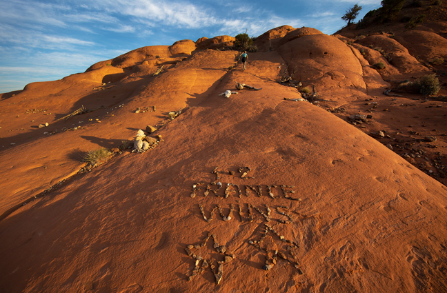
We had been to the park before, but had stayed in Cannonville, seven miles to the north. This time we stayed in one of the park’s nicely furnished rental cabins, complete with electricity, air conditioning and a small fridge. Because most of the state had campfire and Covid restrictions, we brought our own prepared food. In our previous visit, I photographed Shakespeare Arch which collapsed in May 2019, shortly after our visit. This time we hiked Panorama Trail, a six-mile loop trail through the western part of the park and spent two nights photographing the Milky Way.
©Rich Beckman
Shakespeare Arch Trail, Kodachrome Basin State Park, UT, July 2018
We got to the park before sunrise and climbed to the top of the mesa that overlooks Shakespeare Arch (collapsed in May 2019), The Sentinel and The Grand Staircase. On the route to the top of the mesa, I stopped to read the sports update from the 2018 World Cup: France 4 – Croatia 2, while Cynny kept climbing.
©Rich Beckman
The Sentinel, Shakespeare Arch Trail, Kodachrome Basin State Park, UT, July 2018
We got to the park before sunrise and climbed to the top of the mesa that overlooks Shakespeare Arch (collapsed in May 2019), The Sentinel and The Grand Staircase. The Sentinel is one of the 67 documented sedimentary pipes found in the park.
©Rich Beckman
Shakespeare Arch (12S-413196-4151500, Span: 18 ft, Height: 12 ft.), Shakespeare Arch Trail, Kodachrome Basin State Park, UT, July 2018
We got to the park before sunrise and climbed to the top of the mesa that overlooks Shakespeare Arch (collapsed in May 2019), The Sentinel and The Grand Staircase. The arch can be seen in shade in the lower center of photo.
©Rich Beckman
Shakespeare Arch (12S-413196-4151500, Span: 18 ft, Height: 12 ft.), Shakespeare Arch Trail, Kodachrome Basin State Park, UT, July 2018
Shakespeare Arch collapsed in May 2019.
©Rich Beckman
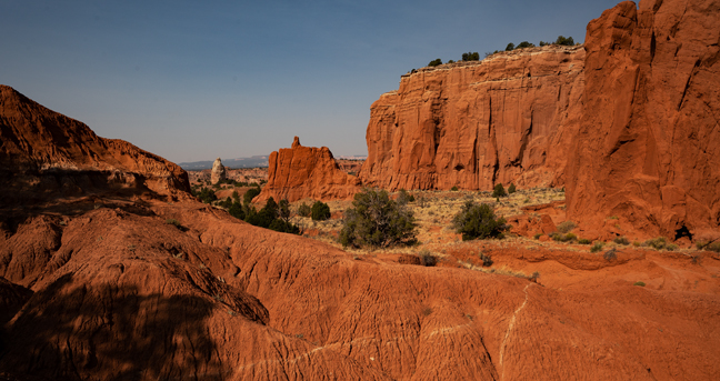
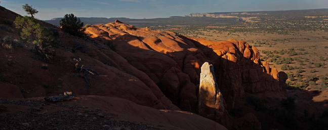
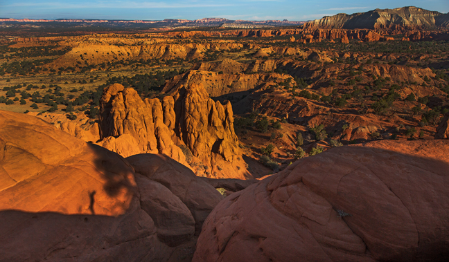
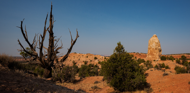
Panorama Trail Long Loop, Kodachrome Basin State Park, UT, September 2020
The 5.8 mile Panorama Trail Long Loop passes by many of the landmarks in the western side of the park, including Fred Flintstone Spire, Panorama Point, Mammoth Geyser, Cool Cave, Secret Passage, Hat Shop, Ballerina Spire and Indian Cave. Mammoth Geyser (actually a sedimentary pipe), seen in the distance, is the largest pipe in the park.
©Rich Beckman
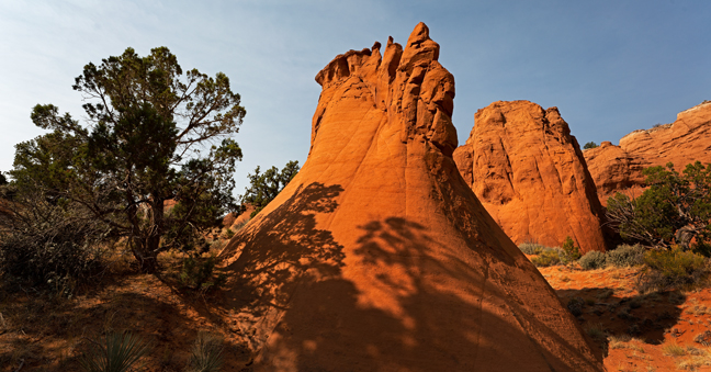
Fred Flintstone Spire, Panorama Trail Long Loop, Kodachrome Basin State Park, UT, September 2020
The 5.8 mile Panorama Trail Long Loop passes by many of the landmarks in the western side of the park, including Fred Flintstone Spire, Panorama Point, Mammoth Geyser, Cool Cave, Secret Passage, Hat Shop, Ballerina Spire and Indian Cave.
©Rich Beckman
Panorama Trail Long Loop, Kodachrome Basin State Park, UT, September 2020
The 5.8 mile Panorama Trail Long Loop passes by many of the landmarks in the western side of the park, including Fred Flintstone Spire, Panorama Point, Mammoth Geyser, Cool Cave, Secret Passage, Hat Shop, Ballerina Spire and Indian Cave.
©Rich Beckman
Mammoth Geyser, Panorama Trail Long Loop, Kodachrome Basin State Park, UT, September 2020
The 5.8 mile Panorama Trail Long Loop passes by many of the landmarks in the western side of the park, including Fred Flintstone Spire, Panorama Point, Mammoth Geyser, Cool Cave, Secret Passage, Hat Shop, Ballerina Spire and Indian Cave.
©Rich Beckman
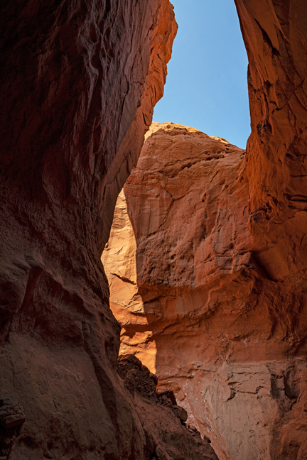
Cool Cave, Panorama Trail Long Loop, Kodachrome Basin State Park, UT, September 2020
The 5.8 mile Panorama Trail Long Loop passes by many of the landmarks in the western side of the park, including Fred Flintstone Spire, Panorama Point, Mammoth Geyser, Cool Cave, Secret Passage, Hat Shop, Ballerina Spire and Indian Cave. Cool Cave is not a true cave, but more of a short canyon that ends in a shady alcove.
©Rich Beckman
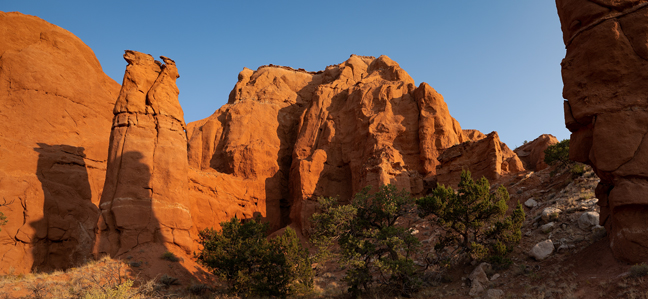
Secret Passage, Panorama Trail Long Loop, Kodachrome Basin State Park, UT, September 2020
The 5.8 mile Panorama Trail Long Loop passes by many of the landmarks in the western side of the park, including Fred Flintstone Spire, Panorama Point, Mammoth Geyser, Cool Cave, Secret Passage, Hat Shop, Ballerina Spire and Indian Cave. These smooth sloping Entrada formations are found at the exit of the spur trail to Secret Passage.
©Rich Beckman
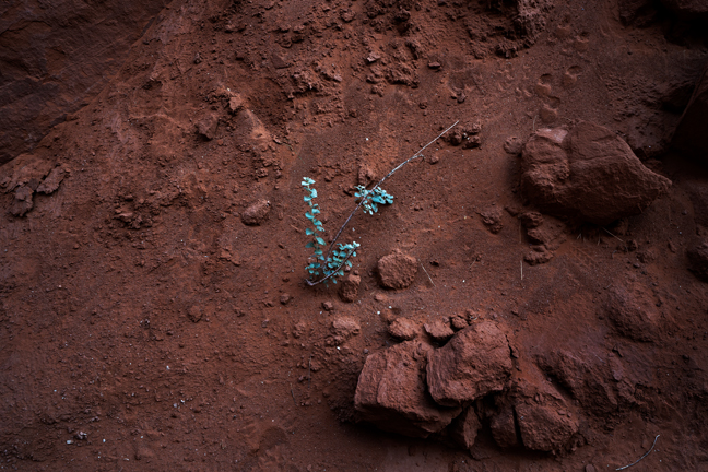
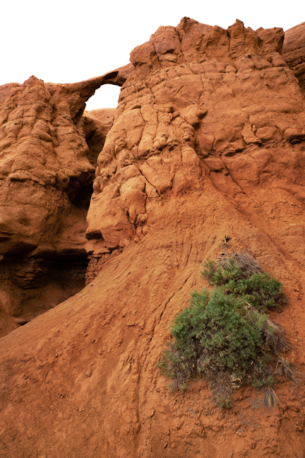
Roundleaf Buffaloberry, Secret Passage, Panorama Trail Long Loop, Kodachrome Basin State Park, UT, September 2020
The 5.8 mile Panorama Trail Long Loop passes by many of the landmarks in the western side of the park, including Fred Flintstone Spire, Panorama Point, Mammoth Geyser, Cool Cave, Secret Passage, Hat Shop, Ballerina Spire and Indian Cave.
©Rich Beckman
Ballerina Spire, Panorama Trail Long Loop, Kodachrome Basin State Park, UT, September 2020
The 5.8 mile Panorama Trail Long Loop passes by many of the landmarks in the western side of the park, including Fred Flintstone Spire, Panorama Point, Mammoth Geyser, Cool Cave, Secret Passage, Hat Shop, Ballerina Spire and Indian Cave.
©Rich Beckman
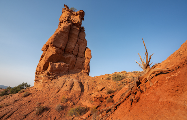
Sedimentary Pipe, Kodachrome Basin State Park, UT, September 2020
Sedimentary Pipes are sandstone spires, believed to be found nowhere else. Their origin is debated. One explanation is that the area once featured hot springs and geysers, which eventually filled up with sediment and solidified and over time the sandstone surrounding the solidified geysers eroded. Others believe that the spires resulted from tectonic activity. They range in height from 6.5 to 170 feet. Mammoth Geyer is the largest in mass and Chimney Rock is the tallest.
©Rich Beckman
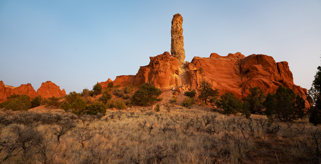
Chimney Rock, Kodachrome Basin State Park, UT, September 2020
Sedimentary Pipes are sandstone spires, believed to be found nowhere else. Their origin is debated. One explanation is that the area once featured hot springs and geysers, which eventually filled up with sediment and solidified and over time the sandstone surrounding the solidified geysers eroded. Others believe that the spires resulted from tectonic activity. They range in height from 6.5 to 170 feet. Mammoth Geyer is the largest in mass and Chimney Rock is the tallest.
©Rich Beckman