Running on Empty
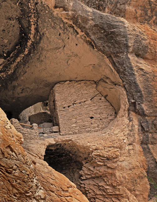
In early May, after finishing my 18-month contract working with a truly great team of colleagues at the Mary Lou Fulton Teachers College and the Herberger Institute for Design and the Arts at Arizona State University https://pi.education.asu.edu/, we wrapped our lone house plant in a suffocating plastic bag (not believing it would actually survive), raised the thermostats, figured out a workaround to the Postal Service’s absurd policy of only holding mail for 30 days, packed the car and headed to Gila Cliff Dwelling National Monument, NM, the first of more than 60 filming locations in 18 states listed on our 24-page, two-month itinerary.
Both of my previous “retirements” were in name only. The first lasted a couple of days and the second a couple of months, but both times, I knew I’d be working again, just someplace new. This one was different. My days of worrying about syllabi, budget cuts, enrollment declines, projects and thesis committees were over. I didn’t have to check in with editors and worry about deadlines. And I didn’t have to keep and record every receipt, document my mileage or worry about staying in only pre-approved lodging in order to stay under my day rate. Yes, this was different.
The length and quick moving nature of the trip was intentional and transitional. Nobody ever prepares you for retirement. Within a moment, you are persona non grata. You are removed from listservs and email threads, you no longer have access to your intranets, you turn in your keys and your name is removed from an office door in a building you can no longer access after hours. You have to figure out a new way to define yourself. My first full-time job in academe began in January 1978 and I had been a tenured professor since 1982. Now, I was a retiree. Yes, the road was a necessary diversion and at times, I, like the car, was running on empty.
For the second straight summer, we scrapped our plans for travel to Europe and Asia due to the ongoing pandemic, but unlike in 2020, much of the U.S. was open and we were confident that with due caution, we could openly interact with other vaccinated colleagues, friends and relatives and access most of our intended locales. That turned out to be overly optimistic as most Native lands were still closed, many National Park and Monument sites had limited access and past and current wildfires, landslides and the extreme heat of human-caused climate change limited our access and activities throughout the trip.
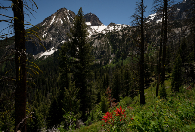
We did manage to spend quality time with more than 35 friends and relatives, some of whom we had not seen in more than a decade, gather more than 20 new refrigerator magnets to add to the wall of magnets that now covers more than 22 square feet of our kitchen and film in about 45 locations. We experienced temperatures ranging from 106º on the Olympic Peninsula (where it was so hot in our hotel room one night that we left the mini-refrigerator door open to help lower the room temperature into the mid-80s) to 38º in Paradise, WA on the slopes of Mt. Rainier (where the trails were still covered with eight feet of snow in early July and a stubborn thick fog settled in the evening we arrived and only lifted the morning we left). My retirement plan on how to avoid the worst of Tucson’s triple-digit summer heat obviously still needs some refining.
Our route included stops in New Mexico, Texas, Oklahoma, Arkansas, Missouri, Illinois, Wisconsin, Michigan, Minnesota, South Dakota, Wyoming, Colorado, Idaho, Washington, Oregon, Nevada and California before returning to Arizona. A majority of the time was spent at elevation in the Pacific Northwest, but I needed to pick up a few things that my brother was storing for me, thus the route via Wisconsin. Our route was not determined by the shortest distances between any two points, but rather on waypoints for natural arches, waterfalls, friends and relatives, classic hikes, location scouting and unfulfilled bucket list locations.
More than four decades ago, one of my first long-term assignments as a photographer was documenting lighthouses and lighthouse keepers along the Atlantic coast for a large anniversary exhibit. Natural arches and waterfalls are a lot like lighthouses. A lighthouse is a tower with a light on top of it, a natural arch is a rock with a hole in it and a waterfall is falling water. All are usually in beautiful locations. All require the right light and composition to come to life. Lighthouses are usually pretty easy to access, but many waterfalls and natural arches are not and the adventure is a large part of the experience and the fun. Waterfalls are usually pretty easy to find. They are well documented and you can hear them, often miles away. Natural arches are silent and secluded. Even with extensive research, you often only have a distant photograph and incorrect GPS coordinates to help guide you. As I am often distant and secluded, we get along well. You’ll likely get bored looking at too many photographs of natural arches and waterfalls in the four slide shows that follow, but if you can imagine the adventure, you’ll understand. Pick out a few that you like and add them to an upcoming itinerary.
As is usually the case, a vast majority of scheduled shooting locations were far from the blue sections of the political map. When Hillary Clinton defined her “basket of deplorables” to include the “racist, sexist, homophobic, xenophobic, Islamophobic—you name it” Trump supporters, she didn’t know to leave room in her basket for the unvaccinated and didn’t know that Stop the Steal, Thin Blue Line, Three Percenter, QAnon and other flags would permeate rural landscapes amongst the assorted Trump 2024 and Confederate flags. Even after 40 years of documenting endangered and disadvantaged populations throughout the world, the hatred and divisions within my own country still disappoint me the most. Many, if not most, are the fault of economic inequality and the failure of our education systems, but the arguments put forth by the unvaccinated are beyond comprehension, especially for someone like me who is immunosuppressed and at severe risk.
Except for a flat tire in Tyler Hansbrough’s hometown of Poplar Bluff, MO, a hard drive that needed to be replaced at the Apple Store in Tacoma, WA, the American Express Fraud Department cancelling my credit card and numerous route and location changes due to road closures, we successfully navigated our way through and around wildfires, heat domes and a couple of massive thunderstorms to explore some of our favorite locations and find a few new favorite places.
We returned home in time to experience the start of the monsoon season, to find Rosie, our programmable robotic vacuum, uselessly trapped in the laundry room, to find that a house plant can survive two months sealed inside a plastic bag, that critters had chewed through much of our irrigation system and that the desert is as beautiful as ever. Enjoy.
Running on Empty, Part I
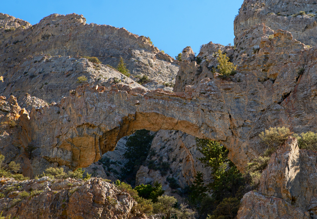
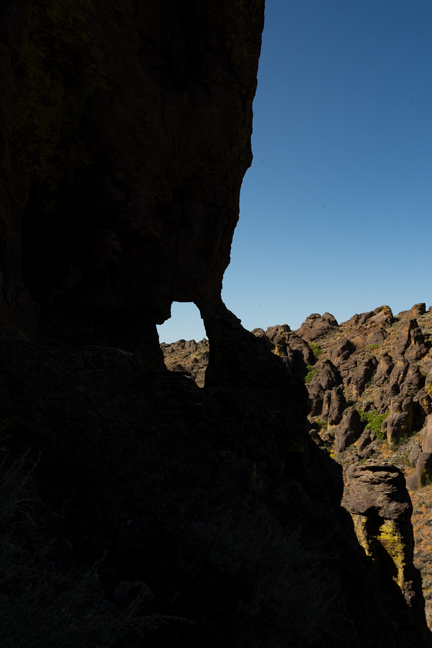
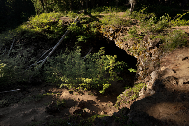
Lava Bridge 9-NM-6 (12S-764904-3870578, 50 ft. x 35 ft.)
El Malpais National Conservation Area, just south of Grants, NM includes two main clusters of natural arches and other significant geological, cultural and archaeological areas surrounding the Zuni-Bandera volcanic field. The first group, all lava bridges, are accessed via the Big Tubes Trail just a few hundred yards west of the Continental Divide off of CR42. The second cluster is on the east side of the lava field and accessed by heading west at the Sandstone Bluffs turn-off from Route 117. These sandstone arches include Swift Arch, Schmidt Double Arch and La Ventana Arch. All the caves and tubes were closed during our visit.
©Rich Beckman
Swift Arch (13S-241837-3873201, 52 ft. x 18 ft.)
El Malpais National Conservation Area, just south of Grants, NM includes two main clusters of natural arches and other significant geological, cultural and archaeological areas surrounding the Zuni-Bandera volcanic field. The first group, all lava bridges, are accessed via the Big Tubes Trail just a few hundred yards west of the Continental Divide off of CR42. The second cluster is on the east side of the lava field and accessed by heading west at the Sandstone Bluffs turn-off from Route 117. These sandstone arches include Swift Arch, Schmidt Double Arch and La Ventana Arch. All the caves and tubes were closed during our visit.
©Rich Beckman
Schmidt Double Arch (13S-241667-3872640, 19 ft. x 15 ft.)
El Malpais National Conservation Area, just south of Grants, NM includes two main clusters of natural arches and other significant geological, cultural and archaeological areas surrounding the Zuni-Bandera volcanic field. The first group, all lava bridges, are accessed via the Big Tubes Trail just a few hundred yards west of the Continental Divide off of CR42. The second cluster is on the east side of the lava field and accessed by heading west at the Sandstone Bluffs turn-off from Route 117. These sandstone arches include Swift Arch, Schmidt Double Arch and La Ventana Arch. All the caves and tubes were closed during our visit.
©Rich Beckman
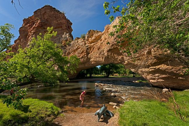
La Ventana Arch (13S-236849-3862617, 135 ft. x 80 ft.)
El Malpais National Conservation Area, just south of Grants, NM includes two main clusters of natural arches and other significant geological, cultural and archaeological areas surrounding the Zuni-Bandera volcanic field. The first group, all lava bridges, are accessed via the Big Tubes Trail just a few hundred yards west of the Continental Divide off of CR42. The second cluster is on the east side of the lava field and accessed by heading west at the Sandstone Bluffs turn-off from Route 117. These sandstone arches include Swift Arch, Schmidt Double Arch and La Ventana Arch. All the caves and tubes were closed during our visit.
©Rich Beckman
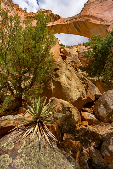
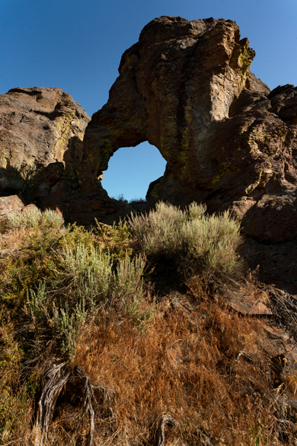
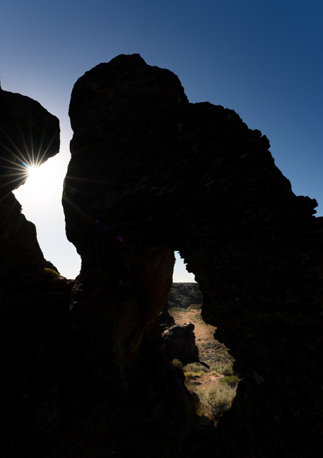
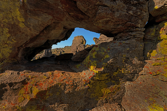
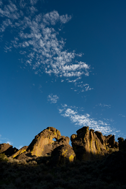
Rendija Arch (13S-380038-3974566, 15 ft. x 12 ft.)
Located in northwest Los Alamos, NM, Rendija Arch is accessed via the Natural Arch Spur Trail off the popular Old Mitchell Trail. The cool and cloudy early morning we climbed to the arch coincided with the fifteenth annual 50-mile Jemez Mountain Trail Run that includes sections of the Old Mitchell Trail. From the 7,000+ ft. elevation, we had great seats to watch the race as we waited to see if a few sparse rays of sunlight would illuminate the arch.
©Rich Beckman
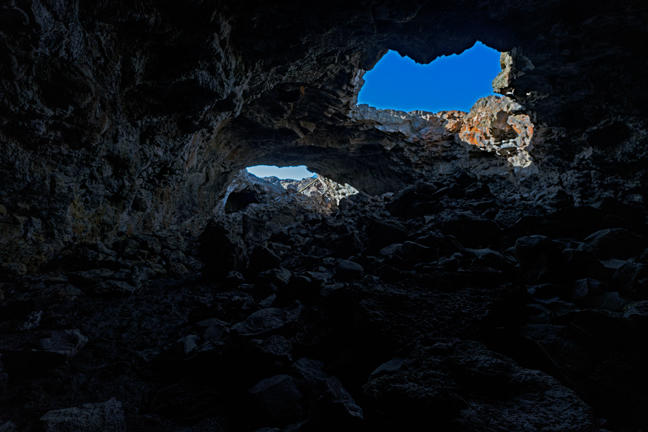
Bat Cave Arches (13S-384620-3960810)
The arches are in the walls of Frijoles Canyon above the Tyuonyi Pueblo Ruins on the Pueblo Loop Trail in Bandelier National Monument near Los Alamos, NM. Most of the pueblo structures within the monument date from either 1150 or 1600 AD.
©Rich Beckman
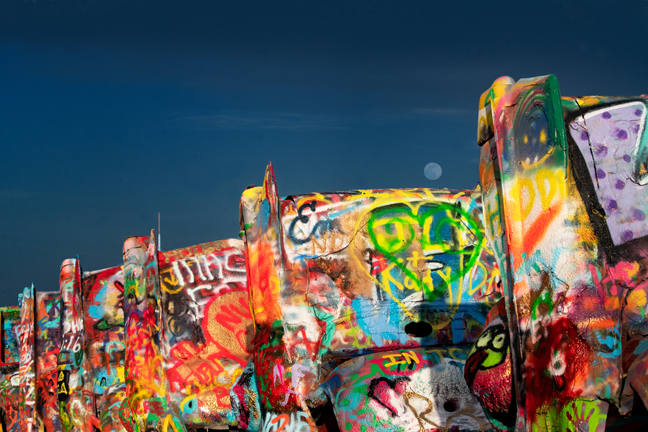
Cadillac Ranch, Amarillo, TX
Whenever I am in the area, I like to spend a few hours at Cadillac Ranch, the ever-evolving spray-painted collection of 10 Cadillacs buried hood-first in 1974 in a wheat field along Route 66 just outside of Amarillo, TX. The installation by a group of self-proclaimed art-hippies from San Francisco is one of the must-see roadside attractions in the world. It now comes complete with its own on location spray paint vendor truck in case you arrive without the required supplies.
©Rich Beckman
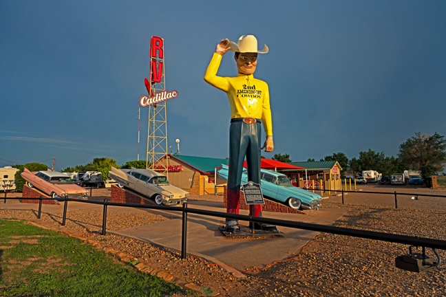
2nd Amendment Cowboy, Amarillo, TX
Adjacent to Cadillac Ranch is the 2nd Amendment Cowboy. Before being purchased in 2014 and moved to front the Amarillo West RV Park, he advertised in front of the Country Barn BBQ & Steaks in Amarillo. Three Cadillacs are jacked up behind him with mannequins resembling Elvis, John Wayne and Willie Nelson at the wheel. The attached faux Texas Historical Marker includes a quote from George Washington that reads, “A free people ought not only be armed and disciplined, but they should have sufficient arms and ammunition to maintain a status of independence from any who might attempt to abuse them, which would include their own government.”
©Rich Beckman
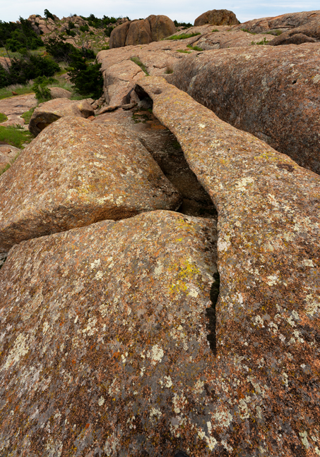
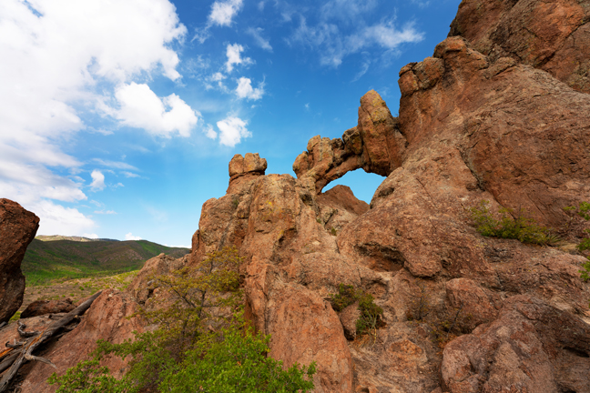
Centennial Arch (14S-525142-3842364, 40 ft. x 4 ft.)
This difficult-to-find arch is located in a remote section of the Wichita Mountains National Wildlife Refuge in the Charons Gardens Wilderness. If you follow the Elk Mountain Trail to the end, you can bushwhack the remaining .3 miles down from the summit to the arch by following the GPS coordinates. I can confirm that there are large rattlesnakes in the area.
©Rich Beckman
Petit Jean Natural Bridge (15S-504908-3883794, 30 ft. x 22 ft.)
Arch is located in Petit Jean State Park, Arkansas’s first state park, in Morrilton, AR. The Park is a certified Trail of Tears National Historic Trail site and has a lodge, cabins and a restaurant, all built by the Civilian Conservation Corps beginning in 1933.
©Rich Beckman
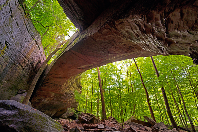
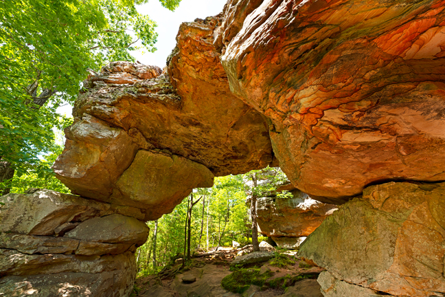
Bell Smith Bridge (16S-353804-4153590, 120 ft. x 22 ft.)
This arch is one of the largest natural arches east of the Mississippi River in the U.S. It is in the Bell Smith Springs Recreation Area near Eddyville. IL in the Shawnee National Forest. From the stone steps across Bay Creek, do not follow the obvious trail to the left unless you want to climb onto the arch. Go straight and you will find the arch hugging the adjacent cliff.
©Rich Beckman
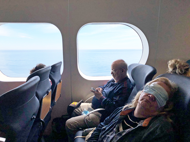
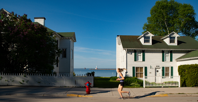
Covid Masks Required, Lake Express High Speed Ferry, Milwaukee to Muskegon
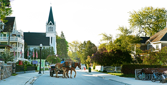
Visiting Arch Rock in Mackinac Island State Park was a great excuse to finally take the ferry from Milwaukee across Lake Michigan, to visit old friends in Harbor Springs, MI and to spend a couple of nights on the island, which I have faint memories of visiting as a child on a family vacation. My memories included the smell of fudge and the famous horse-drawn taxis. In fact, there are currently 13 fudge shops in the island’s small downtown that between them import 10 tons of sugar a week. Many also offer homemade ice cream. I recommend the black cherry on a waffle cone made with fresh Michigan sweet cherries, especially after walking the island’s eight-mile circumference trail. Go counterclockwise to finish downtown.
©Rich Beckman
Dawn, Mackinac Island
Visiting Arch Rock in Mackinac Island State Park was a great excuse to finally take the ferry from Milwaukee across Lake Michigan, to visit old friends in Harbor Springs, MI and to spend a couple of nights on the island, which I have faint memories of visiting as a child on a family vacation. My memories included the smell of fudge and the famous horse-drawn taxis. In fact, there are currently 13 fudge shops in the island’s small downtown that between them import 10 tons of sugar a week. Many also offer homemade ice cream. I recommend the black cherry on a waffle cone made with fresh Michigan sweet cherries, especially after walking the island’s eight-mile circumference trail. Go counterclockwise to finish downtown.
©Rich Beckman
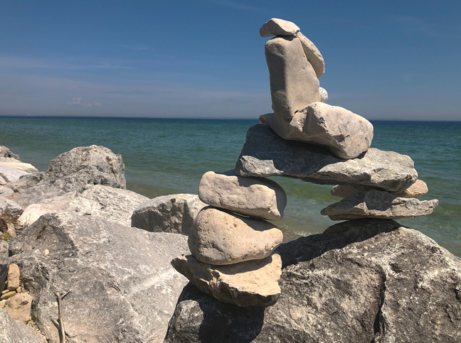
Not Arch Rock, Mackinac Island, MI
In the desert we sometimes stack rocks to make a cairn to mark an otherwise confusing trail. Along the shores of Lake Michigan, people stack rocks as art, as if the shoreline needs art. There are even multiple guide books on the art of rock balancing. In the desert, we often knock over useless cairns. It's not an amusement park. I guess that the lake will eventually reclaim these rocks and return a proper sense of balance to its shoreline.
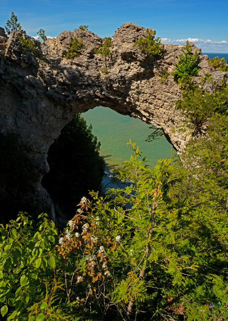
Visiting Arch Rock (V14-1, 16T-685794-5081031, 80 ft. x 50 ft.) in Mackinac Island State Park was a great excuse to finally take the ferry from Milwaukee across Lake Michigan, to visit old friends in Harbor Springs, MI and to spend a couple of nights on the island, which I have faint memories of visiting as a child on a family vacation. My memories included the smell of fudge and the famous horse-drawn taxis. In fact, there are currently 13 fudge shops in the island’s small downtown that between them import 10 tons of sugar a week. Many also offer homemade ice cream. I recommend the black cherry on a waffle cone made with fresh Michigan sweet cherries, especially after walking the island’s eight-mile circumference trail. Go counterclockwise to finish downtown.
©Rich Beckman
Arch Rock (V14-1, 16T-685794-5081031, 80 ft. x 50 ft.)
Visiting Arch Rock in Mackinac Island State Park was a great excuse to finally take the ferry from Milwaukee across Lake Michigan, to visit old friends in Harbor Springs, MI and to spend a couple of nights on the island, which I have faint memories of visiting as a child on a family vacation. My memories included the smell of fudge and the famous horse-drawn taxis. In fact, there are currently 13 fudge shops in the island’s small downtown that between them import 10 tons of sugar a week. Many also offer homemade ice cream. I recommend the black cherry on a waffle cone made with fresh Michigan sweet cherries, especially after walking the island’s eight-mile circumference trail. Go counterclockwise to finish downtown.
©Rich Beckman
Round Island Light and Passage Light, Mackinac Island, MI
Visiting Arch Rock in Mackinac Island State Park was a great excuse to finally take the ferry from Milwaukee across Lake Michigan, to visit old friends in Harbor Springs, MI and to spend a couple of nights on the island, which I have faint memories of visiting as a child on a family vacation. My memories included the smell of fudge and the famous horse-drawn taxis. In fact, there are currently 13 fudge shops in the island’s small downtown that between them import 10 tons of sugar a week. Many also offer homemade ice cream. I recommend the black cherry on a waffle cone made with fresh Michigan sweet cherries, especially after walking the island’s eight-mile circumference trail. Go counterclockwise to finish downtown.
©Rich Beckman
Leland Arch (16T-262419-4803659, 35 ft. x 25 ft.)
The arch is in Wisconsin’s Natural Bridge State Park, although it is not a natural bridge as it was not caused by a river or steam, but by erosive undercutting along a ridge that intersected a steep hillside on the other side of the ridge. Below Leland Arch is an archaeologically excavated rock shelter inhabited in the early Holocene, the time period since the last ice age. Access to the park is 1.1 miles northeast of Leland, WI on Road C.
It was difficult driving through Wisconsin for the first time since my mother died there last November. She loved to travel and we used to take her on road trips around the state on some of the very roads we were driving. When she could no longer travel, we would send her postcards. She kept them in the pouch on her walker long after she could no longer remember who they were from.
©Rich Beckman
Elephant Trunk Rock (15T-721582-4805012, 7 ft. x 4 ft)
This arch is just off State Highway 58 about two miles north of Ithaca, WI. The lower portion of the “trunk” is supported by a cemented cairn of stone. The formation was once known as Devil’s Hitching Post and was likely damaged in 1923 when there was a movement to blast the rock formation to straighten the highway. The area is known as the Driftless Area of Wisconsin and is unique in that none of the four great glacial periods over ran it.
©Rich Beckman
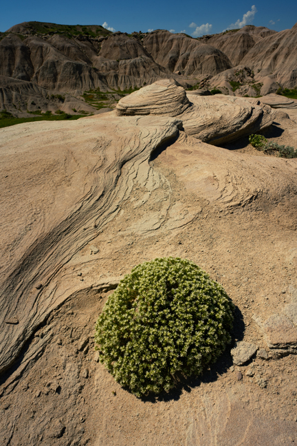
German Knotwort, Toadstool Geologic Park, NE
The park is a collection of badlands formations in the Oglala National Grasslands in northwestern Nebraska. It contains fossils of large prehistoric animals including entelodonts (an extinct family of pig-like omnivores) and hyaenodons (a vicious, carnivorous pack hunter). One of the most significant preservations is a .75-mile-long trackway that reveals an ancient pursuit of hungry entelodonts chasing two species of rhinoceros down a stream channel. The shadeless park is 11.4 miles down a dirt road (Forest Service Road #902) off U.S. Highway 2.
©Rich Beckman
Running on Empty, Part II
Ayres Bridge (V19-8, 13T-449891-4731486, 90 ft. x 22 ft.)
Ayers Bridge, in Natural Bridge Park in Converse County, WY, is about four miles south of Interstate 25 via exit 151, between the towns Glenrock and Douglas. It is only open to the public between April 15 and October 15. It is considered one of Wyoming’s first tourist attractions and was often visited by emigrants traveling the Oregon Trail in the mid-1800s. The site also features an old power house from the early 1900s, build to supply hydropower from the North Platte River for irrigation. The company, North Platte Irrigation, went bankrupt before the project was completed. LaPrele Creek now flows beneath the arch.
©Rich Beckman
V19-9 (13T-352422-4748266, 20 ft. x 12 ft.)
This arch is located on Poison Spider Road about 20 miles west of Casper, WY. There are actually numerous arches in the immediate area which is within an oil field on grazing lands. The approach is a mix of gated public and private roads, some of which are posted with no trespassing signs. There are two large eagle nests in the rock face just south of the arch that were not active during our visit, but that should be scoped before approaching the arch.
©Rich Beckman
Unnamed Arch, Poison Spider Road
This arch is located .25 miles SSE of V19-9 off Poison Spider Road. The rock formation seen through the arch contains V19-9.
©Rich Beckman
V19-12 (13T-298171-4869880 5 ft. x 5 ft.)
This arch is located within the Castle Gardens Scenic Area south of Tensleep, WY. It is located just above the far campsite on the campground loop road and not within the main Badlands formations, which we spent hours exploring in the summer heat due to incorrect GPS coordinates.
Castle Gardens is located between the Big Horn, Beartooth and Owl Creek Mountains, just east of the Absaroka Range and was the site of the Spring Creek Raid in April 1909, in which cattlemen slaughtered thousands of sheep and killed and burned their herders and wagons during the ongoing battle over grazing lands.
©Rich Beckman
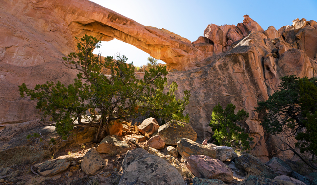
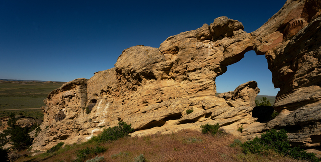
Bridge of the Moon (V19-35, known locally as King’s Mountain Arch, 12T- 317833-4846142, 75 ft. x 60 ft.)
The King Mountain Natural Arch Trail #4343 is approximately a mile long (out and back) if you have a high clearance 4WD vehicle or about two miles from the closet approach without high clearance. It might be possible to navigate the last half mile without high clearance 4WD, but it is a remote area without cell service, so we decided to walk the extra mile. The trail is steep and gets progressively steeper as you approach the arch. The last section, which is probably not part of any actual trail, has an undersized hand rope to help hikers traverse a steep area of loose gravel.
©Rich Beckman
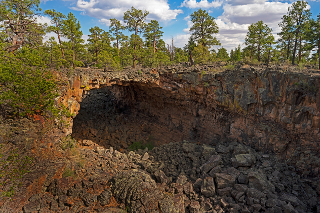
Indian Tunnel, Craters of the Moon National Monument (V19-39, 12T-295270-4813055, 75 ft. x 35 ft.)
Craters of the Moon National Monument and Preserve in the Great Rift Volcanic Zone of the Snake River Plain outside of Arco, Idaho encompasses three major lava fields and covers more than 1,100 square miles. In addition to lava fields, it encompasses scattered islands of cinder cones, sagebrush grasslands and the deepest known open rift crack in the world reaching a depth of 800 ft.
Early explorers imagined that the area resembled the surface of the moon, but NASA astronauts discovered that the craters on the moon were almost all created by meteors while those in the Monument were created by volcanic eruptions. A migrating hotspot, now thought to exist under Yellowstone National Park was under Craters of the Moon 10-11 million years ago.
The Park Rangers on duty during our visit claimed that there were no natural arches in the Monument, yet there are more than 35 documented arches, so do not rely on the staff to provide any guidance. A few arches are easily accessible from marked trails or the loop road, but most require extensive off-trail hiking over rugged lava fields following GPS coordinates.
©Rich Beckman
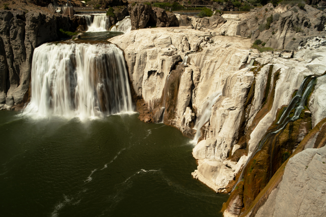
Shoshone Falls, Twin Falls, ID
After almost a month spent visiting friends and photographing natural arches, we opted to begin a more balanced diet and add waterfalls to our itinerary. Mid-June is not the ideal time to begin visiting waterfalls in the Northwest as water flow is often reduced by power and irrigation demands and much of the run-off from winter snows has subsided. Fortunately, many areas of the Northwest had heavy snow accumulation last winter, so we tried to prioritize those. The best time to photograph most waterfalls is early spring. The second best time is whenever you are there.
Shoshone Falls, in Twin Falls, ID, is referred to as the Niagara Falls of the West and at 212 feet it is higher than Niagara Falls. At its annual peak, it is 900 feet wide. During the summer, a portion of the river is diverted for irrigation and by the Fall, it appears almost dry. A trail within Shoshone Park leads to the site where Evel Knievel tried and failed to leap the mile-wide Snake River Canyon on his rocket-powered motorcycle in 1974. Stuntman Eddie Braun successfully completed the crossing on September 16, 2016, nine years after Knievel’s death.
©Rich Beckman
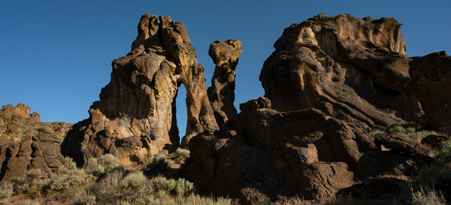
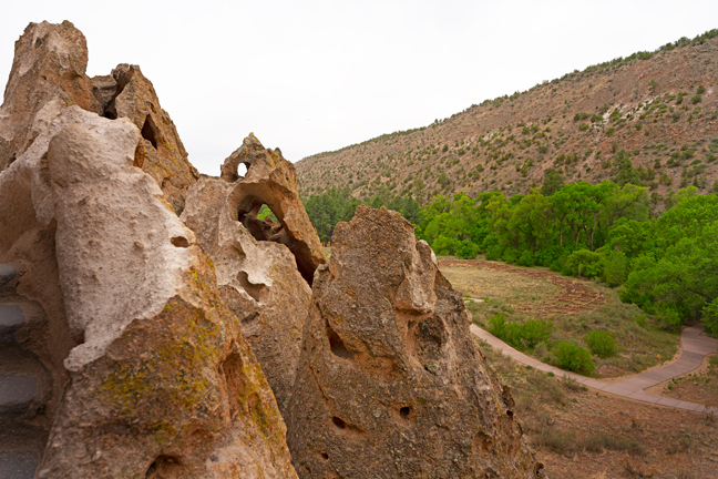
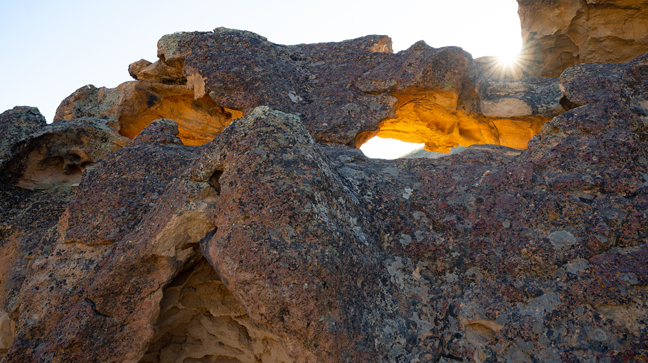
Entrance Arch (11T-688329-4776888, 20 ft. x 5 ft.) Little City of Rocks, Gooding, ID
The first challenge when planning to visit the Little City of Rocks is to figure out where you are going. You are not going to City of Rocks Natural Reserve, although that is certainly worth visiting when you are near Almo, Idaho. It is known as one of the finest granite-face climbing sites anywhere with more than 700 developed climbing routes.
That narrows the process to Little City of Rocks Wilderness Study Area, Gooding City of Rocks West Wilderness Study Area and Gooding City of Rocks East Wilderness Study Area. The turn-off for the one featured here is marked by a BLM sign 12.5 miles north of Gooding, ID on Highway 46 and I still don’t know if it is within one or all the above. Regardless, it features 2,400 acres of volcanic ash hoodoos as well as several natural arches, towers and mushroom caps.
An important part of the experience is staying at the Historic Gooding Hotel Bed & Breakfast, now owned by Dean and Joy Gooding, descendants of Frank Gooding, who founded the city following his second term as Idaho’s sixth governor (and later Senator). I recommend the Senator’s Suite, if for no other reason than to read the framed vintage newspaper clippings that tell of Gooding's history and of the death of the beloved statesman. I also suggest that you request Dean’s famous apple pancakes with applesauce for breakfast and that you discuss anything other than politics with Dean.
©Rich Beckman

Old Feed Mill, Gooding, ID
There's not a lot to do in Gooding, ID on a Monday evening as all of the restaurants are either closed or closed before we returned from scouting the Little City of Rocks. You can sit on the porch at the Gooding Hotel Bed & Breakfast on Main Street and count the number of cars on the passing freight trains or explore the old feed mill across the street that once filled many a freight car with grain.
©Rich Beckman
LCR-15 (11T-688175-4776900, 9 ft. x 8.2 ft.).
The first challenge when planning to visit the Little City of Rocks is to figure out where you are going. You are not going to City of Rocks Natural Reserve, although that is certainly worth visiting when you are near Almo, Idaho. It is known as one of the finest granite-face climbing sites anywhere with more than 700 developed climbing routes.
That narrows the process to Little City of Rocks Wilderness Study Area, Gooding City of Rocks West Wilderness Study Area and Gooding City of Rocks East Wilderness Study Area. The turn-off for the one featured here is marked by a BLM sign 12.5 miles north of Gooding, ID on Highway 46 and I still don’t know if it is within one or all the above. Regardless, it features 2,400 acres of volcanic ash hoodoos as well as several natural arches, towers and mushroom caps.
An important part of the experience is staying at the Historic Gooding Hotel Bed & Breakfast, now owned by Dean and Joy Gooding, descendants of Frank Gooding, who founded the city following his second term as Idaho’s sixth governor (and later Senator). I recommend the Senator’s Suite, if for no other reason than to read the framed vintage newspaper clippings that tell of Gooding history and of the death of the beloved statesman. I also suggest that you request Dean’s famous apple pancakes with applesauce for breakfast and that you discuss anything other than politics with Dean.
©Rich Beckman
Unnamed Arch, Little City of Rocks (11T-687705-4777784, 9 ft. x 8.2 ft.).
The first challenge when planning to visit the Little City of Rocks is to figure out where you are going. You are not going to City of Rocks Natural Reserve, although that is certainly worth visiting when you are near Almo, Idaho. It is known as one of the finest granite-face climbing sites anywhere with more than 700 developed climbing routes.
That narrows the process to Little City of Rocks Wilderness Study Area, Gooding City of Rocks West Wilderness Study Area and Gooding City of Rocks East Wilderness Study Area. The turn-off for the one featured here is marked by a BLM sign 12.5 miles north of Gooding, ID on Highway 46 and I still don’t know if it is within one or all the above. Regardless, it features 2,400 acres of volcanic ash hoodoos as well as several natural arches, towers and mushroom caps.
An important part of the experience is staying at the Historic Gooding Hotel Bed & Breakfast, now owned by Dean and Joy Gooding, descendants of Frank Gooding, who founded the city following his second term as Idaho’s sixth governor (and later Senator). I recommend the Senator’s Suite, if for no other reason than to read the framed vintage newspaper clippings that tell of Gooding history and of the death of the beloved statesman. I also suggest that you request Dean’s famous apple pancakes with applesauce for breakfast and that you discuss anything other than politics with Dean.
©Rich Beckman
LCR-14 (1T-688172-4776875, 6 ft. x 2.7 ft.) Little City of Rocks, Gooding, ID
The first challenge when planning to visit the Little City of Rocks is to figure out where you are going. You are not going to City of Rocks Natural Reserve, although that is certainly worth visiting when you are near Almo, Idaho. It is known as one of the finest granite-face climbing sites anywhere with more than 700 developed climbing routes.
That narrows the process to Little City of Rocks Wilderness Study Area, Gooding City of Rocks West Wilderness Study Area and Gooding City of Rocks East Wilderness Study Area. The turn-off for the one featured here is marked by a BLM sign 12.5 miles north of Gooding, ID on Highway 46 and I still don’t know if it is within one or all the above. Regardless, it features 2,400 acres of volcanic ash hoodoos as well as several natural arches, towers and mushroom caps.
An important part of the experience is staying at the Historic Gooding Hotel Bed & Breakfast, now owned by Dean and Joy Gooding, descendants of Frank Gooding, who founded the city following his second term as Idaho’s sixth governor (and later Senator). I recommend the Senator’s Suite, if for no other reason than to read the framed vintage newspaper clippings that tell of Gooding's history and of the death of the beloved statesman. I also suggest that you request Dean’s famous apple pancakes with applesauce for breakfast and that you discuss anything other than politics with Dean.
©Rich Beckman
Unnamed Arch, Little City of Rocks
The first challenge when planning to visit the Little City of Rocks is to figure out where you are going. You are not going to City of Rocks Natural Reserve, although that is certainly worth visiting when you are near Almo, Idaho. It is known as one of the finest granite-face climbing sites anywhere with more than 700 developed climbing routes.
That narrows the process to Little City of Rocks Wilderness Study Area, Gooding City of Rocks West Wilderness Study Area and Gooding City of Rocks East Wilderness Study Area. The turn-off for the one featured here is marked by a BLM sign 12.5 miles north of Gooding, ID on Highway 46 and I still don’t know if it is within one or all the above. Regardless, it features 2,400 acres of volcanic ash hoodoos as well as several natural arches, towers and mushroom caps.
An important part of the experience is staying at the Historic Gooding Hotel Bed & Breakfast, now owned by Dean and Joy Gooding, descendants of Frank Gooding, who founded the city following his second term as Idaho’s sixth governor (and later Senator). I recommend the Senator’s Suite, if for no other reason than to read the framed vintage newspaper clippings that tell of Gooding history and of the death of the beloved statesman. I also suggest that you request Dean’s famous apple pancakes with applesauce for breakfast and that you discuss anything other than politics with Dean.
©Rich Beckman
Goat Falls, Sawtooth Wilderness
It’s a beautiful eight-mile (out and back) hike, with more than 1,700 feet of elevation gain, to reach the best viewpoint for Goat Falls in the Sawtooth Wilderness. Getting closer would require extensive bushwhacking and a tenuous descent. The trailhead is located at the Iron Creek Campground, just west of Stanley, ID off Forest Road #619. According to the Northwest Waterfall Survey, Goat Falls, at 650-feet tall, is the tallest waterfall in the state. Goat Lake, the source of the falls is at an elevation of 8,220 ft.
©Rich Beckman
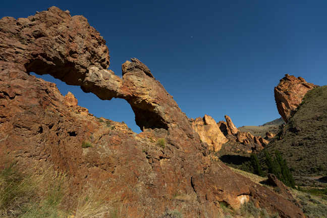
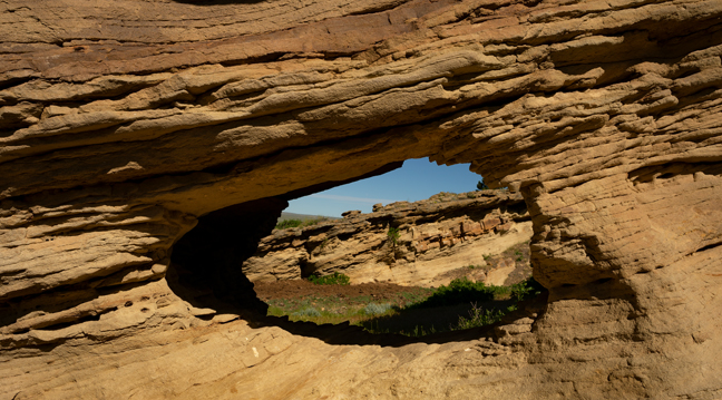
Mud Spring Arch, (11T-479197-4793716, 27 ft. x 10 ft.), Leslie Gulch, OR
We made the hour-long drive to Leslie Gulch from Nampa, ID in search of Mud Spring Arch. If I had researched it further, I would have spent much more than one evening exploring the Gulch. It is a striking area of stark, towering and colorful geologic formations of rhyolite ash that erupted from the Mahogany Mountains caldera 15.5 million years ago and the Three Fingers caldera 100,000 years later.
On our way, we drove right past the arch and thoroughly searched the area surrounding the provided GPS coordinates. It was a beautiful area, just nowhere near the actual location of the arch. The light was beautiful, and we were frustrated when we slowly started the long, unfulfilled drive back to Nampa. After a few “let’s look again” loops around the area, we started out of the Gulch and within a few minutes saw the arch just up a slope to the left of the road. It is angled such that it is easily seen heading east but hidden when driving west. It is just above a cattle guard about nine miles down Leslie Gulch Road.
The Gulch encompasses more than 11,000 acres bounded by watersheds of Leslie, Slocum, Juniper, Dago and Runaway Gulch managed by the BLM as an Area of Critical Environmental Concern. It’s named for Hiram E. Leslie who was struck by lightning there in 1882. The 15-mile dirt road through the Gulch ends at the Owyhee Reservoir, a popular fishing location. The Gulch is home to more than 200 bighorn sheep. A 3.5 mile hike up the Owyhee River leads to the remote, but popular, Echo Rocks Hot Springs.
©Rich Beckman
Runaway Creek Arches, (11T-482234-4795680, 25 ft. x 4 ft.) Lesie Gulch, OR
There are at least five arches within this formation that is visible a few hundred feet southeast of Leslie Gulch Road. The Gulch encompasses more than 11,000 acres bounded by watersheds of Leslie, Slocum, Juniper, Dago and Runaway Gulch managed by the BLM as an Area of Critical Environmental Concern. It’s named for Hiram E. Leslie who was struck by lightning there in 1882. The 15-mile dirt road through the Gulch ends at the Owyhee Reservoir, a popular fishing location. The Gulch is home to more than 200 bighorn sheep. A 3.5 mile hike up the Owyhee River leads to the remote, but popular, Echo Rocks Hot Springs.
©Rich Beckman
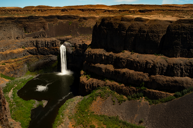
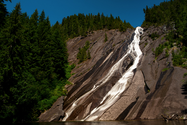
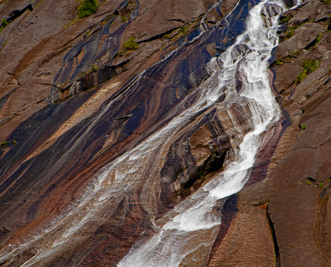
Palouse Falls, Palouse Falls State Park, Washtucna, WA
Palouse Falls is a popular tourist destination in Palouse Falls State Park near Washtucna, WA. The Palouse River drops 200 feet before winding its way through a columnar basalt gorge on its way to the Snake River. Thanks to the efforts of local school children, it was named Washington’s state waterfall in 2014.
©Rich Beckman
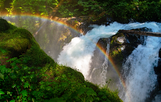
Rainbow Falls, Stehekin, WA
Rainbow Falls is a lovely 312-foot waterfall in Stehekin, WA within North Cascades National Park, but it is not worth the required six and a half hours on a boat from Chelan and a $10/person bus ride that includes a 15-minute stop at the falls with a busload of other tourists.
©Rich Beckman
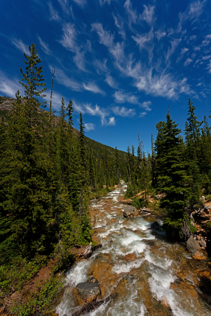
Cutthroat Creek, Methow Valley, WA
Most of the higher elevation trails in the Methow Valley on the east slopes of North Cascades National Park were still impassable in late June due to snow accumulation, so we settled on hiking Cutthroat Creek Trail #483 to Cutthroat Lake. This hike is spectacular in the Fall when the alpine larches and huckleberry bushes are in full color, but unspectacular in the summer. Except for a couple of iffy stream crossings, it is not strenuous.
©Rich Beckman
Running on Empty, Part III
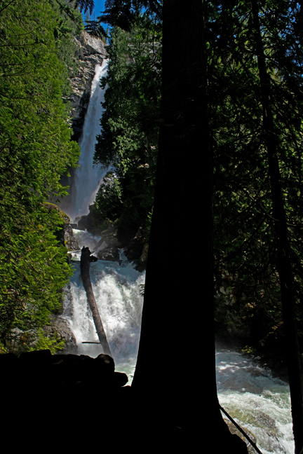
Wallace Falls, Wallace Falls State Park, Gold Bar, WA.
There are three named falls (Lower, Middle and Upper Wallace Falls) along the Woody Trail in the central Cascades, located in Wallace Falls State Park near Gold Bar, WA. The Middle Falls overlook provides a panoramic view of the Skykomish River valley and a view of the Olympic Mountains trailing off into the horizon. We opted not to hike to the Upper Falls as the temperatures were in the 90s and the trail adds an additional half-mile of steep and muddy switchbacks.
©Rich Beckman
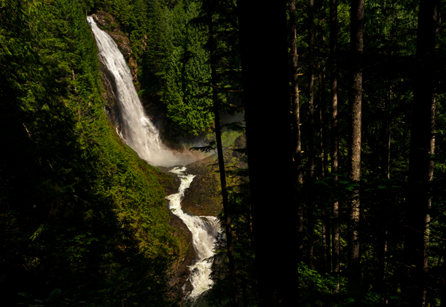
Otter Falls, Baring, WA.
Otter Falls is a 1,200-foot waterfall that streams into Lipsy Lake before draining to the Taylor River. The Snoqualmie Lake Trailhead is 12 miles from the beginning of the Middle Fork Snoqualmie Road, a narrow road that features a few rough spots. The trail crosses several rushing streams that will test your rock-hopping abilities. Identifying and avoiding the loose steppingstones is key to successful crossings.
Moss-laden birches, western red cedars and western hemlocks line the trail that follows the Taylor River and at times, Garfield and Treen Peaks are visible. A short steep path down to a small beach provides a view of the lower 500 feet of the falls as it hugs a huge granite rock face. This trail is suitable for children and dogs and one of each accompanied us. I think that Bear, the dog, enjoyed it more.
©Rich Beckman
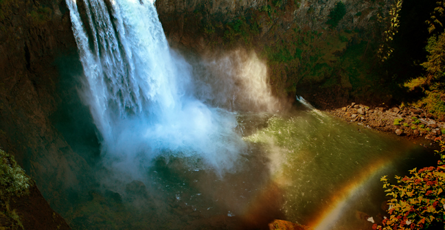
Snoqualmie Falls, Snoqualmie, WA.
Upon leaving North Bend, WA to visit friends in Seattle and on Bainbridge Island before heading out to the Olympic Peninsula, we stopped at the highly developed Snoqualmie Falls. This Falls has its own luxury lodge, a restaurant and shops that sell Snoqualmie Falls Lodge “Old Fashioned” Pancake and Waffle Mix and Snoqualmie Falls Lodge Oatmeal. We didn’t stay long.
©Rich Beckman
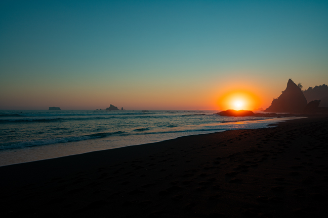
Hole In The Wall Arch (V20-4, 10T-376681-5311145, 29 ft. x 22 ft.)
We approached Olympic National Park from the east during the record-setting late-June heat dome. We waited four hours for our room at Crescent Lake Lodge, which was overrun with day visitors, before leaving when the room was not as advertised. We found lodging and dining in Forks, WA and headed out to Hole-in-the-Wall Sea Arch near the town of Mora on the north end of Rialto Beach.
We had one chance at the photograph I envisioned as low tide and sunset were within minutes of each other and I needed both. The sky was clear, but we were delayed at the restaurant and still had a 1.5-mile hike along the beach to reach the arch as the sun was setting. When we finally reached the site, the obvious route to the lit side of the arch was still blocked by high water. We found an alternate path over a short, but steep hill and then encouraged a few other tourists to take their cell phone photographs and selfies and to get out of my way before the sun set.
Our walk back to the car was much more relaxed than our race to the arch and we survived the night in our un-air-conditioned room at the Far West Hotel with the help of cold showers and a large Mango Slurpee from the Shell station. In the morning, we headed for the coast where the temperatures were 30 degrees cooler.
There were numerous other natural arches that I hoped to photograph on the Olympic Peninsula, but most are on Native lands and both the Makah and Quinault Indian Nation lands were still closed due to Covid. Therefore, we tried to explore sites within the national park.
©Rich Beckman
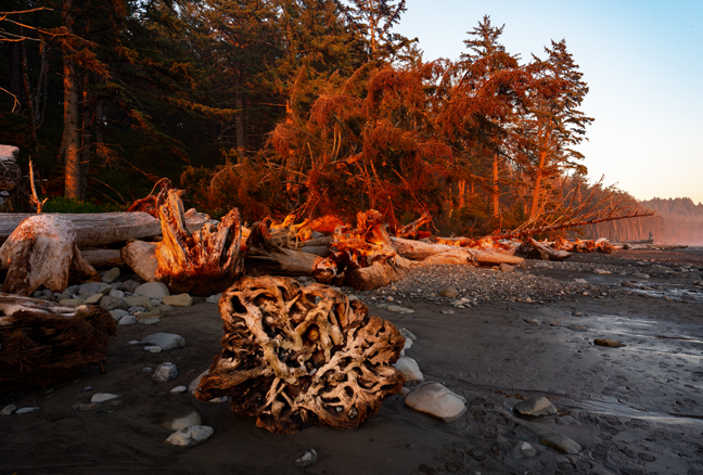
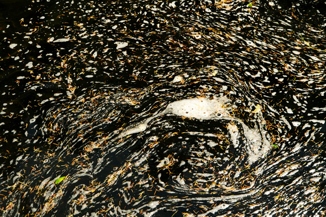
Rialto Beach, Olympic National Park
©Rich Beckman
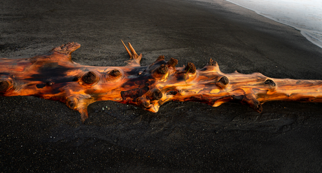
Rialto Beach, Olympic National Park
©Rich Beckman
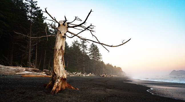
Rialto Beach, Olympic National Park
©Rich Beckman
Rialto Beach, Olympic National Park
©Rich Beckman
Sol Duc Falls, Olympic National Park
It’s a gentle two-mile (out and back) hike to Sol Duc Falls through a lush evergreen rainforest. There are numerous bridges and decks from which to view the falls. That afternoon we decided to hike through the Hoh Rain Forest. A sign on the entry road warned of a 30-minute delay due to road construction. A short distance after passing the construction site traffic was again at a standstill and we were still seven miles from the parking area. After waiting another 30 minutes, the cars in front of us started to turn around. We flagged down one of the passing cars and they had been told that there was an additional 90-minute delay to get into the parking area. We joined the parade and headed back to the beach.
©Rich Beckman
18-WA-7 and 18-WA-8 (10T-393789-5285173, 7 ft. x 3 ft.), Olympic National Park
Ruby Beach, like many of the beaches along the southwest coast of the Olympic Peninsula is known for its fog and it didn't disappoint. We had hope to explore the area north of Cape Alava, particularly Shi Shi Beach, but the tribal closure of the Makah Reservation/Neah Bay and the Ozette Reservation made it impossible.
©Rich Beckman
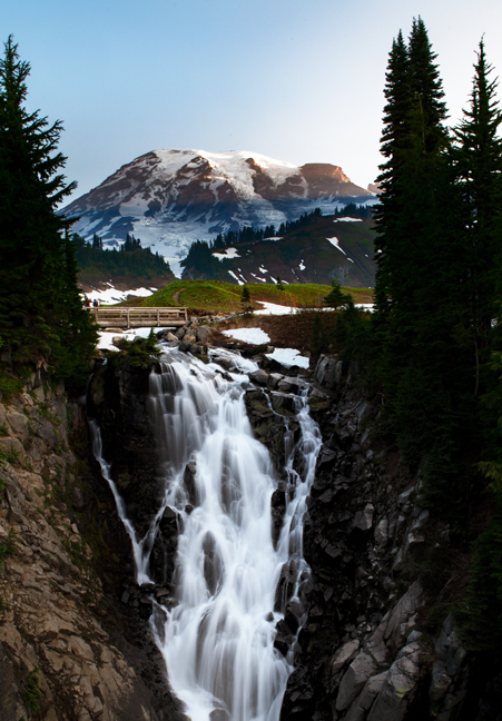
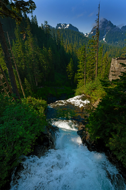
Myrtle Falls, Mount Rainier National Park
We had a beautiful afternoon drive up to Paradise, WA, an area at approximately 5,400 feet on the south slope of Mount Rainier in Mount Rainier National Park. We had a three-night stay at the lodge with a variety of planned hikes and shooting locations. However, due to the past winter’s heavy snows, there was still eight feet of snow on the trails, and they were all closed. A few trails at other elevations were open, but by morning a thick fog had settled over the mountain, and we could barely make out the trees just outside our window.
Mount Rainier has 26 glaciers containing more than five times as much ice and snow as all the other Cascade Range volcanoes combined. It is potentially the most dangerous of the Cascade volcanoes because of its height (14.411 ft.), frequent earthquakes, an active hydrothermal system and an extensive glacier mantle. Even a minor melt from volcanic activity would trigger massive mudflows and debris fields.
The fog barely budged for the next 48 hours so driving up or down the mountain to search for open trails was not a reasonable option. On the morning of our departure, the fog dissipated and had cleared by 4 a.m. We hiked through the snow to Myrtle Falls and arrived before sunrise. We then headed to Reflection Lakes, again walking through ice and snow to see one of the classic views of Mt. Rainier. We then stopped at Narada Falls before heading down the mountain.
©Rich Beckman
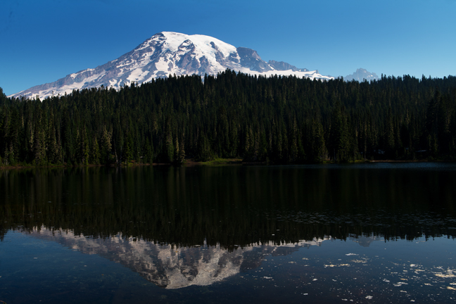
Reflection Lakes, Mount Rainier National Park
We had a beautiful afternoon drive up to Paradise, WA, an area at approximately 5,400 feet on the south slope of Mount Rainier in Mount Rainier National Park. We had a three-night stay at the lodge with a variety of planned hikes and shooting locations. However, due to the past winter’s heavy snows, there was still eight feet of snow on the trails, and they were all closed. A few trails at other elevations were open, but by morning a thick fog had settled over the mountain, and we could barely make out the trees just outside our window.
Mount Rainier has 26 glaciers containing more than five times as much ice and snow as all the other Cascade Range volcanoes combined. It is potentially the most dangerous of the Cascade volcanoes because of its height (14.411 ft.), frequent earthquakes, an active hydrothermal system and an extensive glacier mantle. Even a minor melt from volcanic activity would trigger massive mudflows and debris fields.
The fog barely budged for the next 48 hours so driving up or down the mountain to search for open trails was not a reasonable option. On the morning of our departure, the fog dissipated and had cleared by 4 a.m. We hiked through the snow to Myrtle Falls and arrived before sunrise. We then headed to Reflection Lakes, again walking through ice and snow to see one of the classic views of Mt. Rainier. We then stopped at Narada Falls before heading down the mountain.
©Rich Beckman
Narada Falls, Mount Rainier National Park
We had a beautiful afternoon drive up to Paradise, WA, an area at approximately 5,400 feet on the south slope of Mount Rainier in Mount Rainier National Park. We had a three-night stay at the lodge with a variety of planned hikes and shooting locations. However, due to the past winter’s heavy snows, there was still eight feet of snow on the trails, and they were all closed. A few trails at other elevations were open, but by morning a thick fog had settled over the mountain, and we could barely make out the trees just outside our window.
Mount Rainier has 26 glaciers containing more than five times as much ice and snow as all the other Cascade Range volcanoes combined. It is potentially the most dangerous of the Cascade volcanoes because of its height (14.411 ft.), frequent earthquakes, an active hydrothermal system and an extensive glacier mantle. Even a minor melt from volcanic activity would trigger massive mudflows and debris fields.
The fog barely budged for the next 48 hours so driving up or down the mountain to search for open trails was not a reasonable option. On the morning of our departure, the fog dissipated and had cleared by 4 a.m. We hiked through the snow to Myrtle Falls and arrived before sunrise. We then headed to Reflection Lakes, again walking through ice and snow to see one of the classic views of Mt. Rainier. We then stopped at Narada Falls before heading down the mountain.
©Rich Beckman
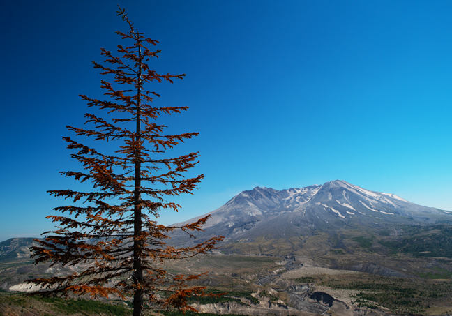
Mt. St. Helens National Volcanic Monument, WA
The skies remained clear and we decided to make the drive over to Mt. St. Helens before heading to Portland. It has been more than 41 years since the May 18, 1980 eruption, the deadliest and most economically destructive volcanic event in U.S. history and it was interesting to see how the area is still recovering. The eruption reduced the elevation of the mountain from 9,677 ft. to 8,363 ft.
©Rich Beckman
Punchbowl Falls, Eagle Creek Trail 440
We spent five nights in Portland over the July 4th holiday where more than a dozen friends and relatives were due catch-up visits. We also hiked the first three miles of the recently re-opened Eagle Creek Trail 440, that features a dozen waterfalls along its six-mile length. Unfortunately, we got a late start that morning and the heat returned, so we only completed half of the iconic trail that cuts through the Columbia Gorge National Scenic Area.
©Rich Beckman
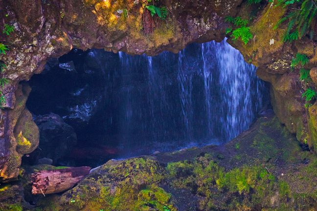
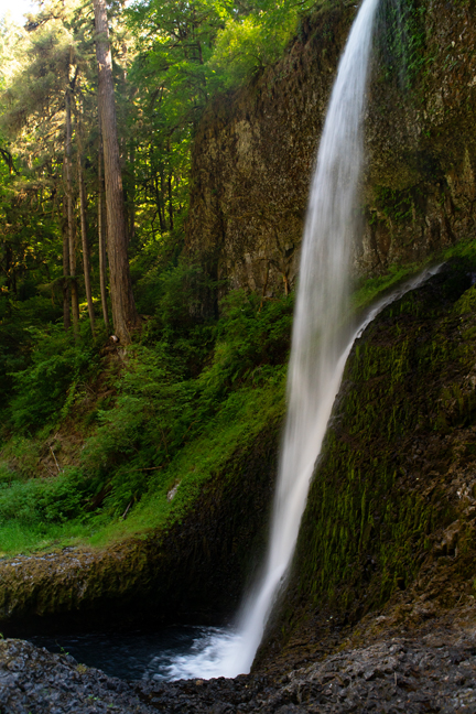
Curly Creek Falls and Arches (10T-579421-5101121)
Leaving Portland, we headed back up into Washington hoping for a clear night for Milky Way photography at a couple of classic lighthouse locations. Of course, there was not a visible star in the sky that night so the next morning we headed back inland to Curly Creek Falls, that in the spring, flows between two natural arches. After winding our way on numerous Forest Service dirt roads, we eventually found the short trail to the falls and arches. Unfortunately, the water levels were low and no water was flowing between the arches. In addition, the only accessible viewpoint was from across the Lewis River. After being a month too early to hike at Mt. Rainier, we were here at least a month too late. And this was just the beginning of impending misfortune as wildfires had begun to block roads and reduce air quality throughout Oregon, Washington and California.
©Rich Beckman
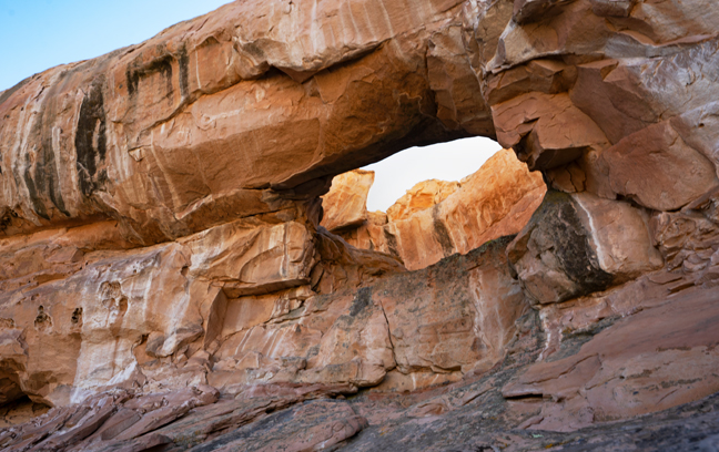
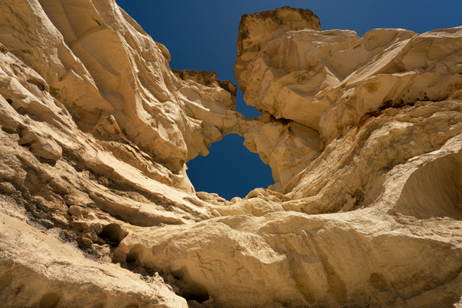
Natural Bridges (V20-13, 10T-604092-5090124, 52 ft. x 14 ft.)
Before leaving the Gifford Pinchot National Forest and heading back to Oregon, we went to find the site signed as Natural Bridges. These are not actually natural bridges but are natural arches that were formed from collapsed lava tubes. (A natural bridge is a type of natural arch where a current of water, such as a stream, clearly was a major agent in the formation of the opening.) Two arches span the collapsed lava tube near Peterson Prairie. The tube itself, known as the Big Trench, is almost a mile in length and varies between 20 and 75 feet deep.
©Rich Beckman
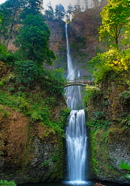
Multnomah Falls, Columbia River GorgeNational Scenic Area
On our drive back to Oregon, we decided to stop and see Multnomah Falls, another of the tourist attraction waterfalls in the area. The Falls are accessed directly off I-84 at a special exit installed expressly for visiting the attraction. When the parking lot is full, they close the highway exits. Coming from the east, the exit was closed but we could see that the parking lot was not full so we drove an additional five miles until we could turn around. We followed the signs that directed us to the Historic Columbia River Highway, but it took us past the Multnomah Falls lodge, but not to the Falls. We turned around again, drove past the closed exit again, drove the additional five miles again and this time approached on I-84 from the west. The exit from this direction was open and we finally joined hundreds of other cars in the parking area as the low fuel light came on.
©Rich Beckman
Running on Empty, Part IV
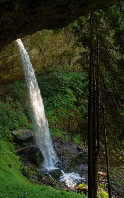
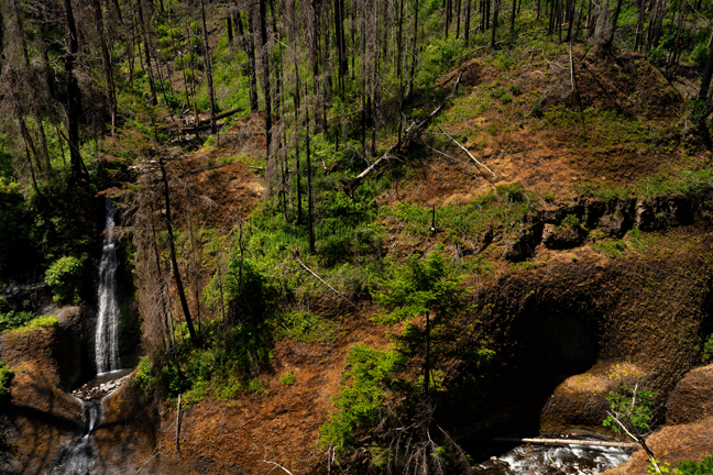
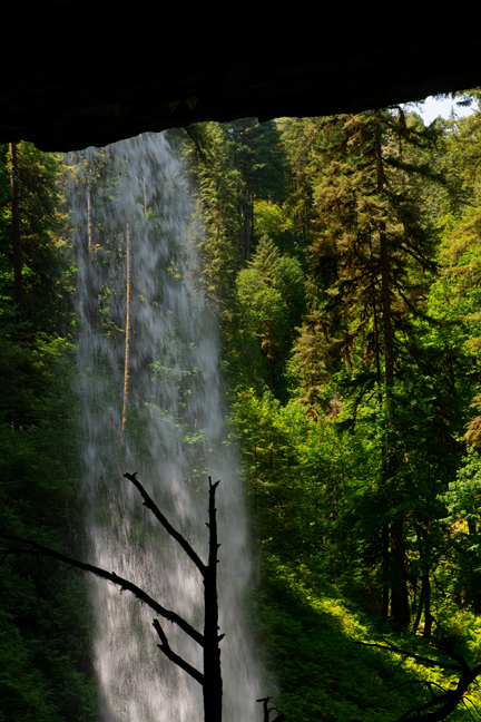
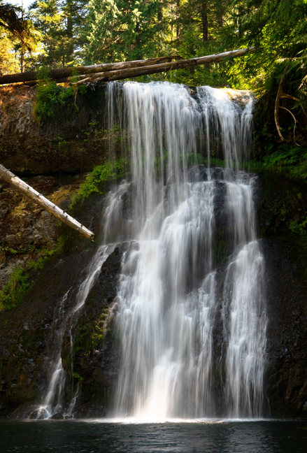
Trail of Ten Falls, Silver Falls State Park, Silverton, OR
We arrived in Silverton, OR in time sample the local beers and ciders at an outdoor craft festival with a live music stage before heading out the next morning on the nearby Trail of Ten Falls in Silver Falls State Park. Unlike Eagle Creek Trail 440, which advertises a dozen waterfalls, many of which are distant views, the falls along the Trail of Ten Falls are intimate. You walk behind or right up to almost all of them and only one, Winter Falls, the last along the loop if you start at South Falls and go clockwise along the nine mile trail, lacked sufficient flow. Unfortunately, the return from the Winter Falls viewpoint requires a significant climb back up to the main trail. Regardless, this is a great hike and it was a beautiful day. There is even a snack bar at the end of the hike that sells excellent root beer floats.
©Rich Beckman
Devil's Punchbowl (10T-415662-4955406), Devils Punchbowl State Park, Otter Crest, OR
Many of our scheduled activities moving forward had to be cancelled due to continued land and road closures attributable to past and present wildfires in the Santiam State Forest and the Willamette National Forest, so we decided to head back to coastal Oregon to visit Devil’s Punchbowl in the small community of Otter Crest. The Punchbowl is a large bowl naturally carved in a rock headland that is partially open to the Pacific Ocean. It was most likely created by the collapse of the roof over two sea caves, then shaped by wave action. The former sea caves now form natural arches. We scouted the area in the evening, but it was cloudy and the required low tide was scheduled for after sunset. We returned for the early morning low tide and soon thereafter the area was swarming with people exploring the tidal pools and risking life and limb climbing onto slippery boulders for selfies.
©Rich Beckman
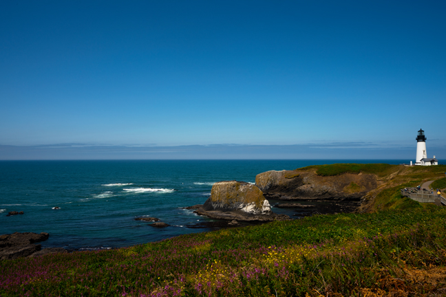
Yaquina Head Lighthouse, Newport, OR
The Yaquina Head Outstanding Natural Area is home to one of the West coast's largest nesting colonies of Common Murre's and is on the migrating path of the Gray Whale (easily spotted in Dec./Jan. and March/April). The 93-foot lighthouse has been active since 1873.
©Rich Beckman
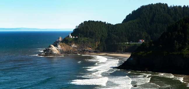
Haceta Head Lighthouse, Yachats, OR
We scouted the Haceta Head Lighthouse, 13 miles south of Yachats, in Heceta Head Lighthouse State Scenic Viewpoint as a possible Milky Way location, but once again by nightfall, the sky was obscured by clouds.
©Rich Beckman
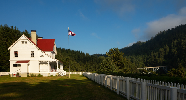
Haceta Lighthouse B&B, Yachats, OR
The B&B is one of the last remaining Lightkeeper's cottages on the Pacific Coast (placed on the National Registry of Historic Places in 1973). It offers six rooms for overnight stays with prices ranging from $405-$574/night. You can rent the entire cottage for $2,959/night. We stayed elsewhere.
©Rich Beckman
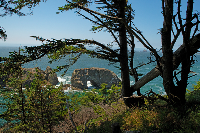
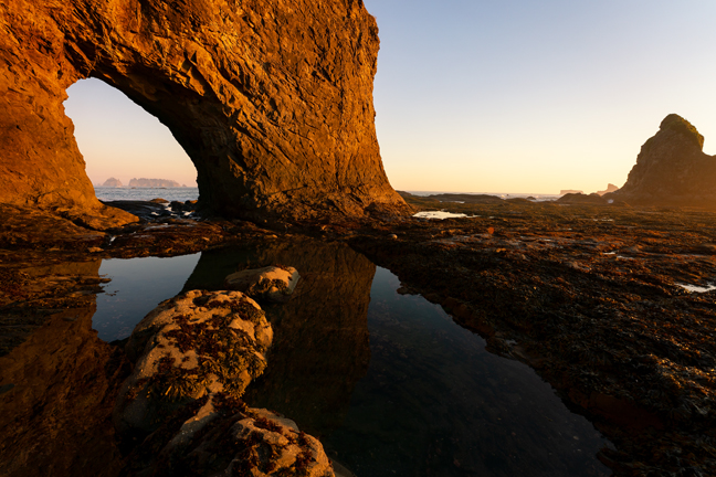
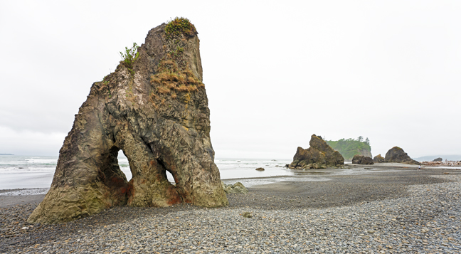
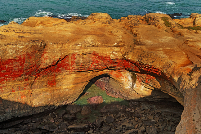
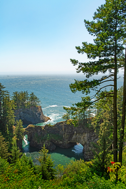
Arch Rock (V20-34, 10T-386245-4672975, 25 ft. x 25 ft.) Samuel H. Boardman State Park
Our next stop was Redwoods National and State Parks in northern California, but because of a landslide and resulting road closures, Highway 101 would not open until 7 p.m. so we spent the afternoon as tourists, stopping at overlooks to see some sea arches. Even under the best conditions, photographing sea aches close to the shoreline is challenging. The soft morning light is usually blocked by the coastal cliffs and unless you come upon a colorful evening sky to use as a background, you need a boat to photograph them from the west in evening light.
In the middle of the day, without a clear path down to the beach, you just hope for some thin clouds to diffuse the light, find some creative compositional elements and then continue on your way.
©Rich Beckman
Natural Bridges (V20-35, 10T-386959-4671754, 20 ft. x 20 ft.) Samuel H. Boardman State Park
Our next stop was Redwoods National and State Parks in northern California, but because of a landslide and resulting road closures, Highway 101 would not open until 7 p.m. so we spent the afternoon as tourists, stopping at overlooks to see some sea arches. Even under the best conditions, photographing sea aches close to the shoreline is challenging. The soft morning light is usually blocked by the coastal cliffs and unless you come upon a colorful evening sky to use as a background, you need a boat to photograph them from the west in evening light.
In the middle of the day, without a clear path down to the beach, you just hope for some thin clouds to diffuse the light, find some creative compositional elements and then continue on your way.
©Rich Beckman
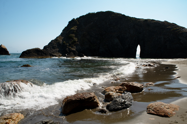
Arch Rock (V20-37, 10T-391357-4657877, 30 ft. x 10 ft.) Harris Beach State Park
It's a short hike down to the beach to visit Arch Rock (V20-37) once you figure out which beach access trail to take. Drive all the way to the parking lot at the end of the road, then circle back up the hill and park in one of the five parking spots along the road. The first beach access path above the parking lot leads directly to the arch.
©Rich Beckman
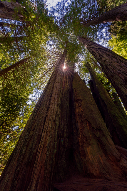
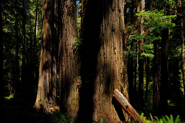
Redwoods National and State Parks
Redwoods National Park is a confusing patchwork of protected areas. Jedediah Smith Redwoods State Park, Del Norte Coast Redwoods State Park and Prairie Creek Redwoods State Park were created by the State of California in the 1920s to protect some of the finest remaining examples of coast redwoods. Congress protected lands adjacent to the three California state parks in 1968 with the creation of Redwood National Park. In 1994, the California Department of Parks and Recreation and the National Park Service agreed to jointly manage the four-park area for maximum resource protection.
There are relatively few facilities in the area, with Klamath, CA being the most developed (one chain hotel, a couple of inns and lodges and a few restaurants). Getting to Klamath required strategic planning as Last Chance Grade on Highway 101, between Crescent City and Klamath, was closed between 8 a.m. and Noon and between 3-7 p.m. due to a landslide. We arrived in Crescent City around 4:30 p.m. and put our name on the waiting list at the Chart Room, the best seafood restaurant in town. Ninety minutes later, we were seated and were back on the road waiting for it to open before 7 p.m. Of course, hundreds of other people had the same idea and it took us two hours to cover the 21.5 miles between Crescent City and Klamath.
We had a permit to hike to the Tall Trees Grove the next day, a limited access four-mile hike with a total elevation gain of 800 feet, all on the return portion of the hike. The Grove is located on the valley floor along a .9 miles loop. This is the go-to hike in the park, although there are numerous hikes with equally tall trees that are much easier to access. It is one of the more remote areas of the park and access is via a six-mile unpaved windy road that is also frequented by fully loaded logging trucks. We encountered four going the opposite direction, all on tight curves.
We also hiked five miles along the James Irvine Trail and drove the Newton B. Drury Parkway located in the heart of Prairie Creek State Park numerous times. The road passes through thousands of acres of old-growth redwood forests. The Parkway is closed to motorized vehicles on the first Saturday of each month so that bikers and hikers can safely enjoy the scenery.
©Rich Beckman
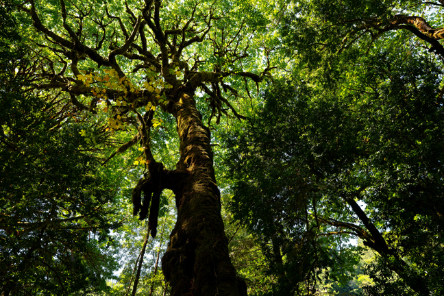
Bigleaf Maple (Acer macrophyllum), Redwoods National and State Parks
Redwoods National Park is a confusing patchwork of protected areas. Jedediah Smith Redwoods State Park, Del Norte Coast Redwoods State Park and Prairie Creek Redwoods State Park were created by the State of California in the 1920s to protect some of the finest remaining examples of coast redwoods. Congress protected lands adjacent to the three California state parks in 1968 with the creation of Redwood National Park. In 1994, the California Department of Parks and Recreation and the National Park Service agreed to jointly manage the four-park area for maximum resource protection.
There are relatively few facilities in the area, with Klamath, CA being the most developed (one chain hotel, a couple of inns and lodges and a few restaurants). Getting to Klamath required strategic planning as Last Chance Grade on Highway 101, between Crescent City and Klamath, was closed between 8 a.m. and Noon and between 3-7 p.m. due to a landslide. We arrived in Crescent City around 4:30 p.m. and put our name on the waiting list at the Chart Room, the best seafood restaurant in town. Ninety minutes later, we were seated and were back on the road waiting for it to open before 7 p.m. Of course, hundreds of other people had the same idea and it took us two hours to cover the 21.5 miles between Crescent City and Klamath.
We had a permit to hike to the Tall Trees Grove the next day, a limited access four-mile hike with a total elevation gain of 800 feet, all on the return portion of the hike. The Grove is located on the valley floor along a .9 miles loop. This is the go-to hike in the park, although there are numerous hikes with equally tall trees that are much easier to access. It is one of the more remote areas of the park and access is via a six-mile unpaved windy road that is also frequented by fully loaded logging trucks. We encountered four going the opposite direction, all on tight curves.
We also hiked five miles along the James Irvine Trail and drove the Newton B. Drury Parkway located in the heart of Prairie Creek State Park numerous times. The road passes through thousands of acres of old-growth redwood forests. The Parkway is closed to motorized vehicles on the first Saturday of each month so that bikers and hikers can safely enjoy the scenery.
©Rich Beckman
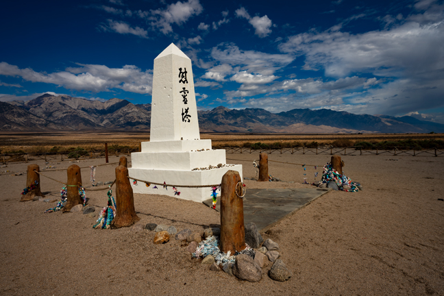
Manzanar War Relocation Center National Historic Site, CA
Due to numerous wildfires in the region, we decided to change our route and start heading for home. We stopped in Big Pine, CA hoping to drive up to Shulman Grove to walk among the Bristle Cone Pines, the oldest living trees in the world, but thunderstorms in the area made it unsafe, so we continued south and stopped at the Manzanar War Relocation Center National Historic Site, one of ten camps where the US government incarcerated Japanese immigrants ineligible for citizenship and Japanese American citizens during World War II. There is almost nothing left to see, but still a sobering experience filled with wrongly persecuted ghosts.
We continued south, stopping in Lone Pine, CA at one of our favorite donut shops and spent the night in Twentynine Palms, CA, mostly to have dinner at The Rib Co., a required culinary dive. In the morning we drove through Joshua Tree National Park before intersecting with I-10 and driving the final 332 miles home.
©Rich Beckman