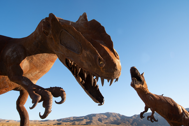
Fighting Dinosaurs, Galleta Meadows, Borrego Springs, CA
Our first stop was Borrego Springs, CA, a community of less than 2,000 year-round residents that is completely surrounded by Anza Borrego Desert State Park, the largest state park in California.
Between 2008 and 2012, philanthropist Dennis Avery commissioned artist Ricardo Breceda to design and build the 131 metal sculptures of dinosaurs and other creatures, many based on species that had once roamed Borrego Springs and other parts of Southern California. They remain scattered around the properties he owned in Borrego Valley, which he called Galleta Meadows. Avery was heir to the fortune from the Avery Dennison Corporation (formerly the Avery Adhesive Label Corporation) and died in 2012. He and his wife lived in Borrego Springs, 90 miles from San Diego, where he had worked for the city attorney’s office as one of its first consumer fraud attorneys.
The fighting dinosaurs depicted in this sculpture, Allosaurus (left) and Carnotaurus (right) never actually encountered one another. Allosaurus lived in the Jurassic period and inhabited Africa, Europe and North America. Carnotaurus lived in South America during the Late Cretaceous period.
©Rich Beckman
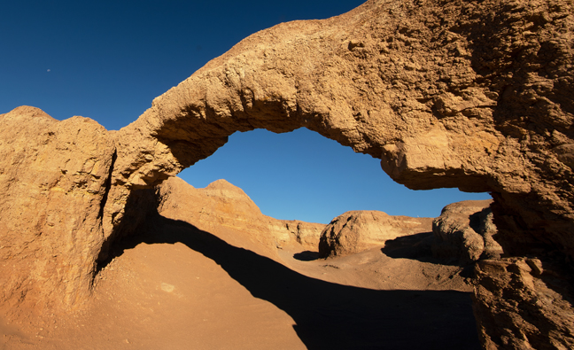
Coral Wash Bridge (11S-0592369-3685317, 12’x10’)
Coral Wash Bridge is in the Truckhaven area of Ocotillo Wells State Vehicular Recreation Area, about 1.6 miles west of State Highway 86 in a sandy wash. It is between Anza Borrego Desert State Park and the Salton Sea. You can drive to and under the arch with 4WD.
©Rich Beckman
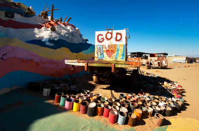
Salvation Mountain, Imperial County, CA
Salvation Mountain, was created from adobe bricks, discarded tires, windows and automobile parts by Leonard Knight beginning in 1984. It features numerous murals that incorporate Bible verses and Christian sayings based on the Sinner’s Prayer. Knight died in 2014 after spending the last 30 years of his life working on the 50 foot-tall mountain. He slept at the base of the mountain in the back of his pick-up truck. The religious folk art now serves as a centerpiece for Slab City, a squatter art community, and is managed by a public charity. Much of it was inaccessible and in need of repair when we visited in June 2022. (1/2)
©Rich Beckman
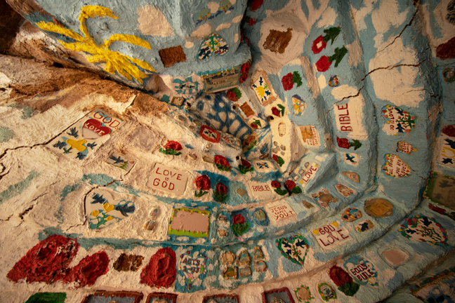
Interior Room, Salvation Mountain, Imperial County, CA
Salvation Mountain, was created from adobe bricks, discarded tires, windows and automobile parts by Leonard Knight beginning in 1984. It features numerous murals that incorporate Bible verses and Christian sayings based on the Sinner’s Prayer. Knight died in 2014 after spending the last 30 years of his life working on the 50 foot-tall mountain. He slept at the base of the mountain in the back of his pick-up truck. The religious folk art now serves as a centerpiece for Slab City, a squatter art community, and is managed by a public charity. Much of it was inaccessible and in need of repair when we visited in June 2022. (2/2)
©Rich Beckman
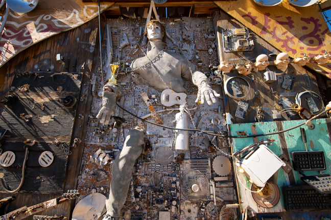
Art Garden at East Jesus, Slab City, CA
The entrance to The Art Garden at East Jesus is just north of Salvation Mountain. The outdoor gallery is open and free, sunrise to sunset, 365 days a year. It is the only art museum in Imperial County and is run solely on donations (http://eastjesus.org/art-garden/). It describes itself as an experimental, habitable, extensible artwork in progress.
Before you visit East Jesus, it is important to read the East Jesus Survival Guide (http://eastjesus.org/east-jesus-survival-guide). Here is one of my favorite sections that will help you understand why this is important:
“EAST JESUS IS NOT A FUCKING ASHTRAY. Smoking is permitted. Go ahead, they’re your lungs. IF WE FIND ONE SINGLE BUTT ON THE GROUND WE WILL FUCKING KILL YOU. That means you will be dead, and it will hurt like hell the whole time you’re dying.… If you knew how many times we’ve bent over to pick up butts, and how much it hurts when we do this, and how much the sight of cigarette butts on the ground fills us with murderous bile, you would understand.”
Upon our arrival, we were immediately met by one of the contributing artists. He explained that the inhabitants of East Jesus provide a refuge for artists, musicians, survivalists, writers, scientists, laymen and other wandering geniuses who are dedicated to providing a working model of an improbable improvised community at the edge of the world. I highly recommend you visit if you happen to be in the area. Actually, you’re never likely to just happen to be in the area, so go out of your way to visit.
©Rich Beckman
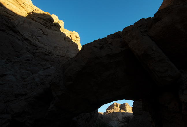
Palm Wash Arch (11S-0583246-3683158, 19’x8’)
Palm Wash Arch is near the 4WD parking area for the South Fork Palm Wash Canyon Trailhead in Anza Borrego Desert State Park. The trail, that goes under the arch and through a slot canyon, is a four-mile out and back if you walk from the main road (Borrego Salton Sea Way, S22) or a 2.8 mile out and back from the 4WD parking area at the start of the slot canyon. The arch is in shadow until late morning as the sun is blocked by the cliff wall to the east.
©Rich Beckman
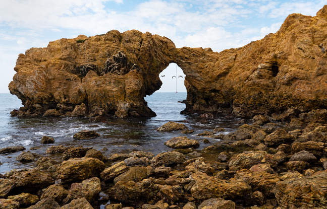
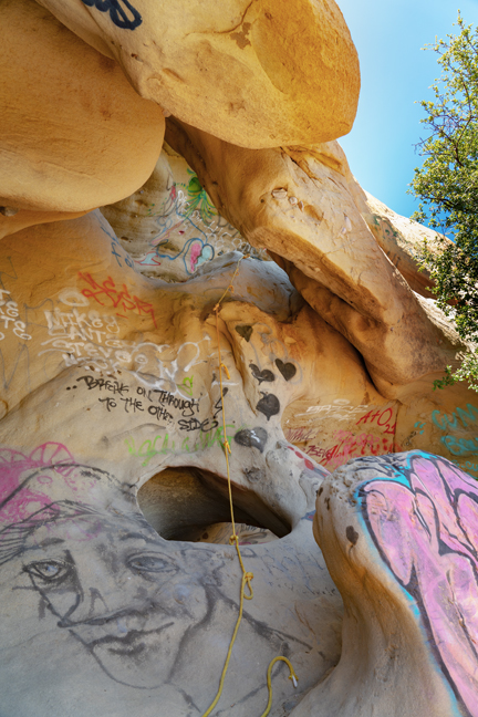
Arch Rock 7, V21-36 (11S-419806-3716430, 15’x20’), Cliff Island, Little Corona Del Mar Beach, CA
After spending a day in Irvine, CA with Aunt Libby, we headed out to Little Corona Del Mar Beach the next morning for sunrise. Unfortunately, this was one of those early mornings when “….clouds got in my way.” There were a few moments of sunlight followed by dark clouds, a morning thunderstorm and then more clouds. Fortunately, our timing was impeccable. We watched the sunrise, took a few photographs and were safely sheltered at the Rose Bakery Café for fresh donuts before the rain started.
We waited out the rain and then returned to the beach and made our way to Cliff Island and the arch. It is probably an easy walk during a minus tide, but it was not and the low tide was not until mid-day when the light would be even worse, so we waded through tidal pools and navigated the slippery boulders to a suitable, though not ideal, vantage point. Fortunately, some Brown Pelicans flew by framed by the arch, so it wasn’t a total waste of time and within a few weeks the gashes on my leg had healed nicely.
The rope hanging from the arch is because many visitors cliff jump from the top of the arch. I checked our itinerary, and fortunately, this was not included.
©Rich Beckman
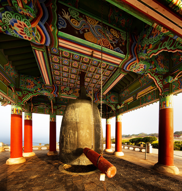
Korean Bell of Friendship, Angels Gate Park, San Pedro, CA
The Korean Bell of Friendship was donated to the people of Los Angeles in 1976 to celebrate the Bicentennial as a way to commemorate and thank the U.S for its participation in the Korean Conflict. It sits on a battery where once a web of catacombs and bunkers housed munitions and men in what was known as the Upper Reservation of Fort MacArthur, now Angels Gate Park. It overlooks the port from which U.S. troops sailed into the Pacific.
Four pairs of figures, each consisting of the Goddess of Liberty and a Korean spirit, are engraved in relief on the body of the bell. Each of the Korean spirits holds a different symbol: a symbolic design of the Korean flag; a branch of the rose of Sharon, Korea’s national flower; a branch of laurel, symbol of victory; and a dove of peace. The bell has no clapper but is struck from the outside with a wooden log.
We didn’t stop in San Pedro to visit the Korean Bell of Friendship, but rather to photograph the Point Fermin Lighthouse and the Queen Mary, in nearby Long Beach Harbor. The famous lighthouse is supposedly open to the public from 1-4 p.m. Tuesday through Sunday, but it isn’t. It’s fenced and the signage says that it’s open by appointment only. It’s unclear why and as it is owned by the City of Los Angeles, there were no answers forthcoming. It’s located in a beautiful coastal park where we enjoyed a nice picnic before exploring San Pedro and seeing the Korean Bell of Friendship. We went to photograph it the next morning at sunrise, but the park was gated and locked. Fortunately, we followed a jogger to an opening through a residential area into the park.
Our visit to the Queen Mary was equally unsuccessful. Although I knew that the former luxury liner was closed for restoration, I didn’t know that the entire area would be roped off and closed to the public. All of the parking lots and access roads were closed and there was nothing to see except miles and miles of shipping containers. The Port of Long Beach moved more than 9.38 million cargo containers in 2021 and is the busiest container port in the Western Hemisphere. Who knew? Who cares?
©Rich Beckman
Unnamed Arches (11S-337756-3772662), Corral Canyon Cave, Backbone Trail, Santa Monica Mountains NRA, CA
After lunch with Jim Seida, a colleague who I worked with in at least a half a dozen countries and dinner with my niece Sarah, her husband Jason and their twin daughters Poppy and Goldie, we headed to Agoura Hills, CA, one of the many access points to the Santa Monica Mountains National Recreation Area and the 67-miles Backbone Trail. It crosses the best-protected stretch of coastal Mediterranean habitat in the world and connects Will Rogers State Historic Park in Pacific Palisades with Point Mugu State Park in Ventura County. There are 12 trailheads along the route and the best one for seeing natural arches begins at the end of Corral Canyon Road. The first half mile traverses a large granite outcropping where most of the arches are located. I wish we had known this before we hiked an additional four miles, as the return hike was all uphill.
On May 2, 2016, California State Parks’ Los Angeles District Superintendent Craig Sap sent out a memo that Corral Canyon Cave, better known as Jim Morrison Cave, would be completely closed to the public until further notice: “….The area has become popular with the public after a rumor began through social media that Jim Morrison from The Doors was said to have frequented the location. As a result large crowds have shown up on a daily basis to see the often vandalized cave and in some cases add to the vandalism with graffiti of their own. While State Park Rangers have been successful in catching and arresting several individuals for felony vandalism, however the graffiti of the cave and surrounding area has increased….”
The cave also made news headlines back in November of 2007 when partiers made an illegal campfire and started a wildfire. Nearly 5,000 acres were burned and 50 homes were destroyed.
The dirt parking lot for this hike is located at the end of Corral Canyon road. You turn on Corral Canyon Road from the PCH, the same place you turn for Solstice Canyon, and then head up the small two-lane road for five miles. At the end, it turns into dirt, and you drive about 50 feet on the dirt road before reaching the parking lot that holds about ten cars. The hike starts from the parking lot, on the right-hand side, and heads along the Backbone Trail.
We later learned that there were at least seven unsolved shootings in and adjacent to Malibu Creek State Park between November 2016 and June 2018, including the murder of a camper who was asleep in his tent with his two young daughters. The park is just north of the trail we were hiking.
©Rich Beckman
Pinnacles High Peak Loop Trail, Pinnacles National Park, CA
We diverted from our northern trek to spend a night in Pasadena, CA to attend the Los Angeles premiere of “The Human Trial,” a film by Guy Mossman, one of my former graduate students, and his wife Lisa Hepner and to have lunch with Steven Tepper, who is Guy’s brother-in-law, a former colleague from UNC-CH and a friend for more than 30 years. The next morning, we headed north to our campsite at Pinnacles National Park.
The 9.3 mile High Peak Loop Trail traverses many of the major sites within the national park, one of the smallest in the country, encompassing about 42 square miles. In 1908 President Theodore Roosevelt created Pinnacles National Monument and legislation to make it a national park was signed by President Obama on January 10, 2013.
The park is located near the San Andreas fault and The Pinnacles are part of the Neenach Volcano which erupted 23 million years ago.
A California condor re-establishment program has been in place since 2003. The first nest since reintroduction was built in 2010, and Pinnacles now manages a population of 25 free-flying condors. Pinnacles National Park joined the California Condor Recovery Program as a release and management site in 2003. The park co-manages all of the wild condors in central California along with the Ventana Wildlife Society.
In 1967, condors were listed as an endangered species. Despite this protection, their population continued to decrease and dropped to a low of 22 individuals in the 1980s. All wild condors were then trapped and placed in captive breeding programs in an effort to save the species from extinction. As of the end of 2018, there were a total of 488 condors in the world, with 312 of those flying free in the wild.
During our hike we saw numerous large black birds soaring on the early morning thermals amidst The Pinnacles. Most were likely Turkey Vultures, as we didn’t see any birds with tags or transmitters, but some were likely condors. It's a challenging hike, so that's our story and we're sticking to it.
©Rich Beckman
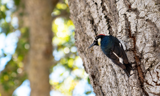
Acorn Woodpecker (Melanerpes formicivorus), Pinnacles National Park, CA
Upon returning to the parking area from hiking the Pinnacles High Peak Trail, we watched an Acorn Woodpecker hunting for bugs on a nearby tree. Acorn Woodpeckers are best known for their behavior of hoarding acorns. They drill small holes in a dead snag, then harvest acorns in the fall and store them in these holes, to be eaten during winter. Such "granary trees" may be used for generations and may be riddled with up to 50,000 holes.
They are also unusual in that they live in large groups and breed cooperatively with multiple males and females combining efforts to raise young in a single nest.
©Rich Beckman
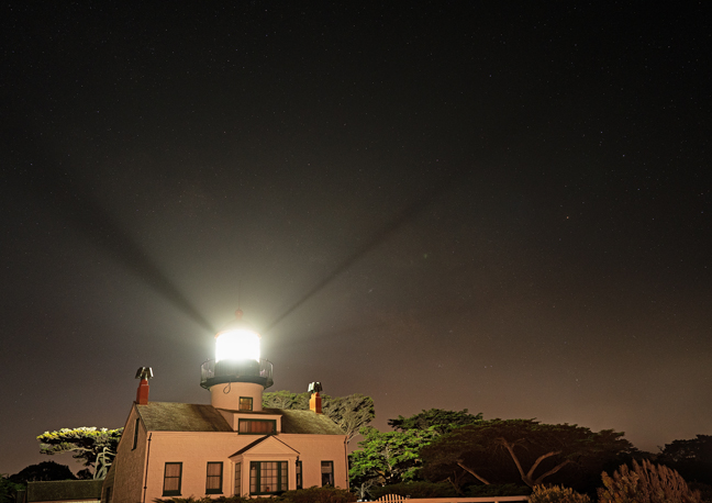
Point Pinos Lighthouse, Pacific Grove, CA
After dinner with friends Bonnie and Myra in Salinas, CA, our next stop was Carmel, CA. to photograph the Point Pinos Lighthouse and Soberanes Arch. The lighthouse is the oldest continually operating lighthouse on the West Coast and on the National Register of Historic Places. The building, lenses and prisms are all original, and it is still an active aid to navigation. Built in 1855, it is one of six lighthouses along the coast for which Congress appropriated funds shortly after California statehood was ratified. Initially, whale oil was used to fuel the light, then in 1880, the lighthouse shifted to kerosene for fuel. In 1919, it was electrified.
Today, the fenced lighthouse is adjacent to a golf course and only open a few hours on weekends and then only if volunteers are available. Otherwise, it is not easy to access and is surrounded by No Trespassing signs, especially at night. The goal was to photograph the lighthouse under the Milky Way, but few stars were visible once the haze moved in from the ocean.
©Rich Beckman
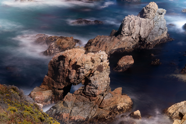
Soberanes Arch (10S-596302-4035231, 12’), Garrapata State Park, Carmel, CA
This famous sea arch is located in the California Sea Otter State Game Reserve in Garrapata State Park, just south of Carmel on State Highway 1 off Soberanes Point. Access to the overlook, which requires following a social trail to the edge of a cliff, was challenging due to high winds.
©Rich Beckman
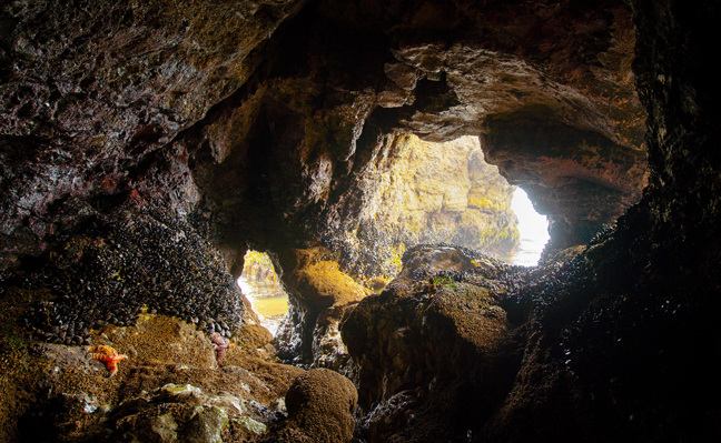
Arch 9-CA-29 (10S-0513730-4206875), Pt. Reyes National Seashore, CA
Our next stop was Pt. Reyes National Seashore where there are numerous sea arches on Sculptured and Secret Beaches, many of which can only be accessed during a minus tide. Unlike the directions we got at the Visitors Center, they can also be accessed by walking on the beach without detouring onto the Coastal Trail. Once we corrected that error, we stalled at a steep drop that required navigating a few slippery boulders. Fortunately, a young couple showed us the way and stood by to make sure we didn’t fall.
An Ochre Sea Star (Pisaster ochraceus) clings to a mussel bed adjacent to sea arch 9-CA-29, one of a series of arches on Sculptured Beach.
©Rich Beckman
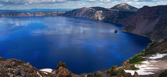
Crater Lake National Park, Crater Lake, OR
We were scheduled to visit Crater Lake National Park last summer, but the nearby wildfires forced us to cancel those plans and reschedule for this summer. So, after a night in the Bay area with friends Karen and David and watching the White Sox defeat the Giants, we escaped the intolerable California gasoline prices and headed into Oregon. Crater Lake is 6,178 feet above sea level and the Park advises guests to visit in July, August and September when the park's roads, trails and facilities are fully open. We arrived on July 4, which I guess does not qualify, because only one trail was open due to the heavy winter snows and even that trail required crossing multiple deep, slippery snow fields.
Once it stopped raining, everybody, including us, headed for the same trail, so it was a pretty typical national park experience. And, of course, the roof of the lodge was being replaced that month which meant that the main entrance to the lodge was closed between 7 a.m. and 7 p.m. If you stay in the lodge, there is one restaurant, that requires reservations that can only be made on-site and a nearby snack bar that closes at 4:30 p.m. The restaurant, which is buffet only, was quite good, as well it should be for $52/person.
I don’t know what the solution is for our national parks. Many have instituted quota systems that require advanced reservations just to enter the park. Those that have lodges charge rates that most people can’t afford and even then you can’t get a reservation months in advance. Roads and trails are overcrowded and visitors often wait for hours in traffic or in lines. Other parks require shuttles or buses to see the park. I’m glad that I got to experience our national parks when they were still accessible. Now, I avoid them when I can and that’s just very sad as they are spectacular.
©Rich Beckman
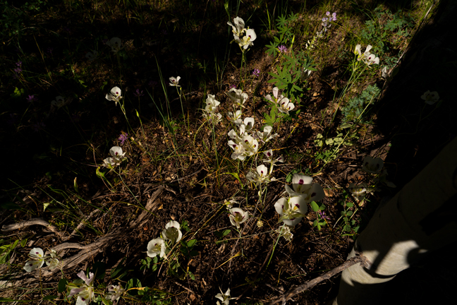
Smokey Mariposa, Calochortus Leichtlinii, Castle Rocks Trail, Castle Rocks State Park, Almo, ID
Castle Rocks State Park in Almo, Idaho is the antithesis of a national park. There is a lodge that you can reserve, but when you do, you are the only occupant. It’s actually a house that’s called a lodge and it has a full kitchen, multiple bedrooms, a dining room and multiple living areas. It only has one bathroom, no air conditioning and there’s a small noisy bunkhouse too close by, but it’s still a great and affordable place to stay in a lovely park that’s only five miles from the City of Rocks Natural Reserve. Rock climbers know these places well, but they are also great for hikers and those who want solitude.
On our 5.9 mile morning hike on Castle Rock Trail, that passes most of the major rock climbing sites within the park, we came across a single cluster of Smokey Mariposa, a species of flowering plant in the lily family.
©Rich Beckman
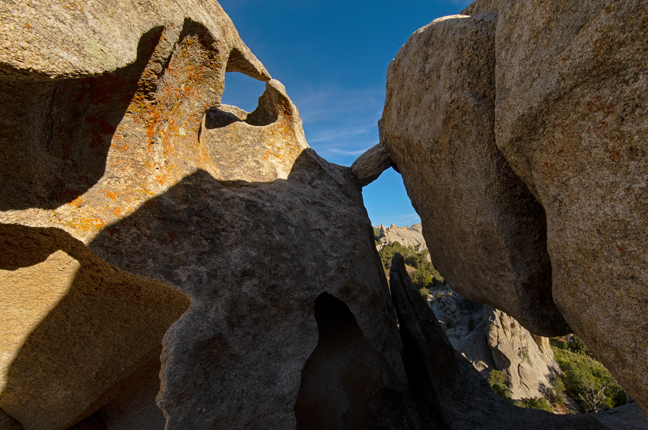
Leaning Arch (12S-275502-4661821, 8.7’x5.4’), City of Rocks Natural Reserve, Almo, Idaho
The City of Rocks Natural Reserve is known as one of the finest granite-face climbing sites anywhere with more than 700 developed climbing routes. It is one of numerous City of Rocks in Idaho. Others include Little City of Rocks Wilderness Study Area, Gooding City of Rocks West Wilderness Study Area and Gooding City of Rocks East Wilderness Study Area. These feature volcanic ash hoodoos as well as several natural arches, towers and mushroom caps.
There are numerous arches in the Reserve, mostly formed in narrow, elongated outcrops that were breached by cavernous weathering. Most are located in the central part of the Reserve where the weathering has been enhanced along a set of north-striking joints and the enlargement of the sidewall tafone.
©Rich Beckman
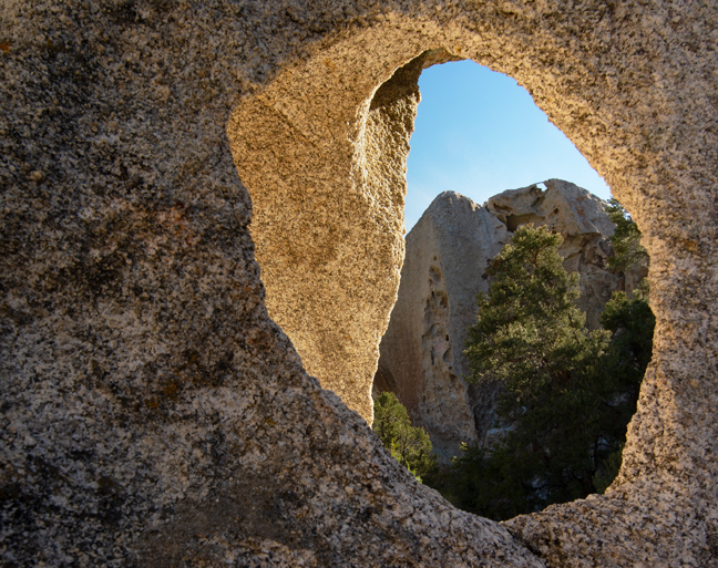
Eagle’s Eye Arch, SCR-33, City of Rocks Natural Reserve, Almo, Idaho
Eagle’s Eye Arch is not the opening in the foreground, but the one at the top of the formation in the background. (1/2)
©Rich Beckman
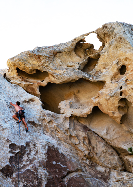
Eagle’s Eye Arch, SCR-33
Some arches are more challenging to visit than others. It was another cloudy morning, without much hope for interesting photographs, when two climbers walked by us near the base of the formation that featured Eagle’s Eye Arch high above. I decide to wait to see what would happen and after a while the first climber headed up the wall, setting carabiners in existing anchors and looping a rope through each. He was essentially free-climbing the wall up to the arch with the ease of a lizard scampering up a rock. (2/2)
©Rich Beckman
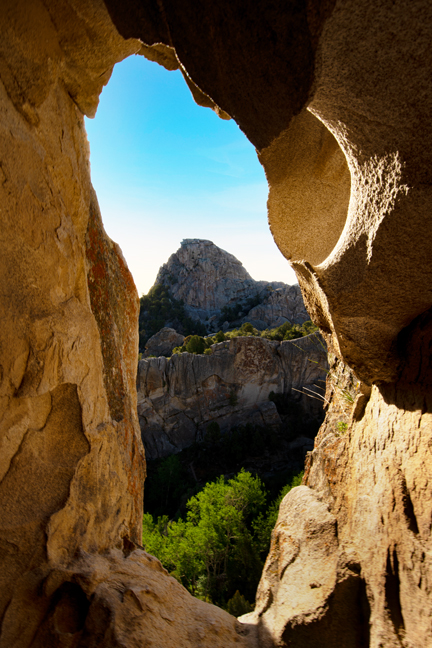
Flaming Rock Arch, SCR-4 (12T-0275642-4661768, 5.7'X3.5'), City of Rocks Natural Reserve, Almo, ID
©Rich Beckman