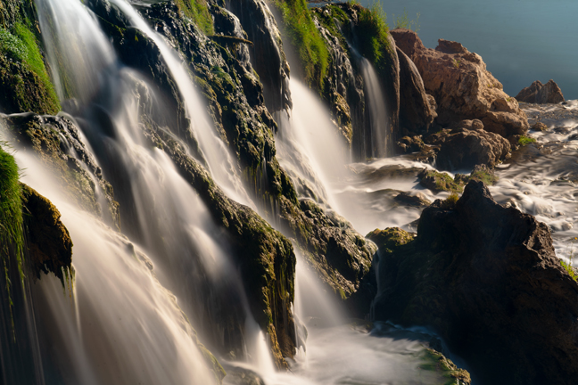
Fall Creek Falls, Swan Valley, Bonneville County, ID
I had an afternoon appointment in Idaho Falls, so after a brief stop at the Idaho Potato Museum in Blackfoot, ID, we made our way north to the big city. The next morning we headed out to find Fall Creek Falls. The falls, with an elevation of 5,280 feet and a 60-foot descent into the Snake River, is located in the Caribou-Targhee National Forest off U.S. Hwy 26 along NF-058 (or Snake River-Palisades Dam Road).
There is a path down to the base of the falls just past the small pull-off for the view from the top, but it was steep and muddy and even though there was a thin rope to assist in the descent, it seemed a bit sketchy to attempt carrying a tripod and cameras. The best way to reach the bottom of the falls is by boat or kayak from the nearby boat ramp.
©Rich Beckman
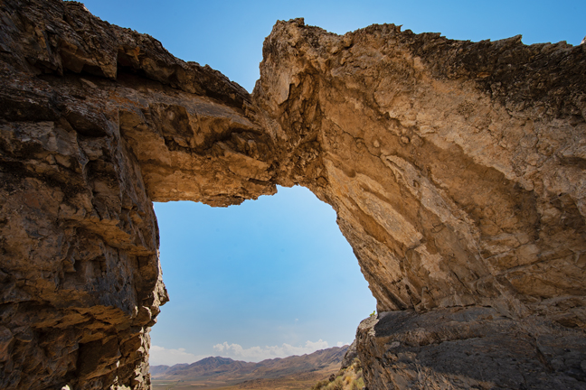
Chinese Arch (12S-374384-4610379, 12’x6’), Golden Spike National Historic Park, UT
After a couple of nights of rest and relaxation at the Riverside Hot Springs Inn in Lava Hot Spring, ID, we turned to the south to begin meandering our way back to Arizona. The Inn has what they call a Seniors Lodging and Dinner Special during the summer that includes a nightly $35 dinner credit, free breakfasts and free access to their onsite mineral hot springs. For some unknown reason, the one-street downtown also hosts an Olympic Swimming Complex and Indoor Aquatic Center where morning lap swims cost $2/day. At no extra cost, we stayed in the Presidential Suite, the same room where Teddy Roosevelt stayed during his visits. Not much has changed in the town since he visited.
Our first stop on our southward journey was Chinese Arch, which is not located in China, but within the Golden Spike National Historic Park, UT along the Promontory Trail Auto Tour Route. The placard at the site says, “More than likely, Chinese Arch was named in recognition of the presence and contribution made by the Chinese who worked on the transcontinental railroad. While the arch was created by forces of nature, today it stands as a memorial to the Chinese who worked for the Central Pacific Railroad. It is an embodiment of the strength and stamina demonstrated during their construction and subsequent maintenance of the transcontinental railroad.”
More than 1,200 Chinese workers died while building the railroad between 1865-1869. In February, 2006, the U.S. Board on Geographic Names approved changing the name of the arch from its original name, Chinaman’s Arch, to the current name, Chinese Arch.
©Rich Beckman
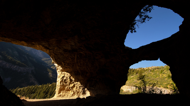
Wind Cave Arches (12S-440363-4623709), Logan Canyon, UT
The next morning, we set out to hike to the Wind Cave Arches. The arches are not in Wind Cave National Park, nor were they formed by the wind, but by underground water sources. They are in the Uinta-Wasatch-Cache National Forest about five miles up Logan Canyon near the Guinavah-Malibu campground. It’s a four-mile out and back hike with about 1,100 ft. of elevation gain, all on the way from the trailhead to the limestone caverns. We passed, or were passed by, about 15 hikers going and up and down the trail and they were all women or dogs.
©Rich Beckman
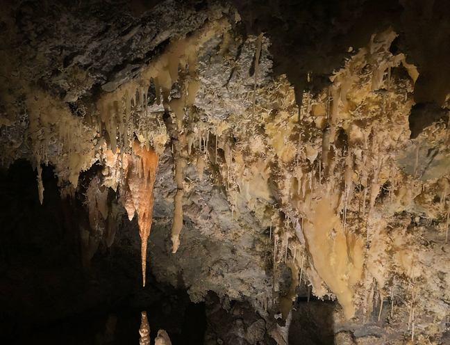
Tipanogos Cave National Monument, American Fork, UT
After climbing 1,100 feet on our two-mile sunrise climb to Wind Cave Arches, we embarked that afternoon on the 1,100 foot 1.5 mile climb to view the Timpanogos Cave System within Timpanogos Cave National Monument. Unlike our lovely shaded early morning hike, this hike required a reservation and ours was for a 2:45 p.m. departure, with afternoon highs in the mid-90s. Also, unlike our morning hike, this is a paved trail of endless switchbacks.
When you reach the cave entrance, you are met by a guide who leads a group of about 15 on a half-hour tour through the open parts of the three caves - Hansen, discovered in 1887 by Martin Hansen, a local settler; Timpanogos Cave discovered in 1915 and Middle Cave in 1921. The first cave tours were in 1922 and on October 14, 1922, President Warren G. Harding used the Antiquities Act of 1906 to set the caves as a National Monument. Once you enter the caves, the average temperature is 45 degrees.
After finishing the tour and hiking back down the mountain, we rewarded ourselves by heading directly to the Sauce Boss Southern Kitchen restaurant in nearby Draper, where we met Chef Julius, one of ten kids raised by his single grandmother in the projects on the south side of Chicago, not far from where I lived as a toddler. After two floured and fried pork chops topped with apple mash with large sides of candied yams and collard greens and too many refills of the sweetest iced tea west of the Mississippi, I was done for the day.
©Rich Beckman
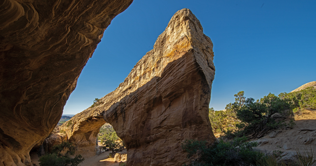
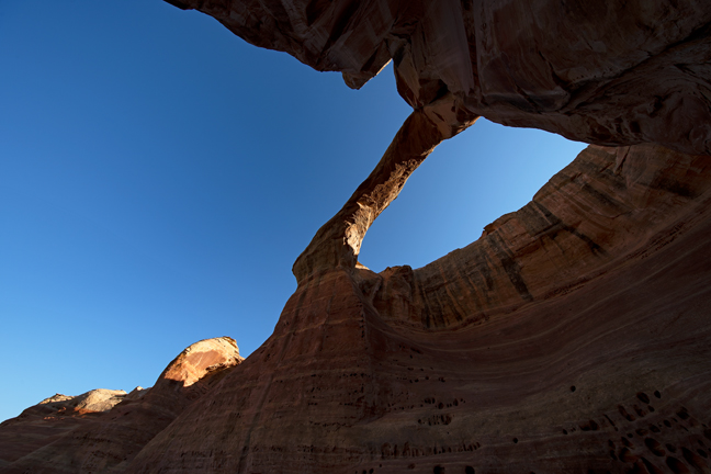
Moonshine Arch (12S-623085-4490507, 80’x70’), Vernal, UT
Our next stop was Vernal, UT. where the big news in town was that they were accepting sealed bids for the refurbishing of the stucco for the T-Rex Dinosaur Statue located at 727 West Highway 40 (next to the Texaco). Vernal is known as the closest lodging for Dinosaur National Monument and for its natural gas production, but our first stop was Moonshine Arch.
You can supposedly drive to this arch, but it’s easier to just walk as it’s less than a mile from the parking area, which is a short drive from Vernal via Highway 191. There’s a large cavern adjacent to the arch that prevents sunlight from illuminating the arch until mid-morning and by then tourists begin to arrive.
©Rich Beckman
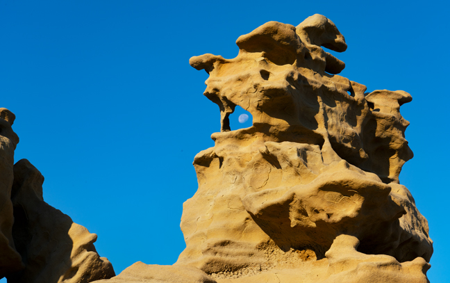
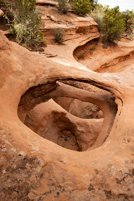
Fantasy Canyon (12T-636951-443541), Vernal, UT
We departed Vernal early the next morning for Fantasy Canyon. We had been to the Canyon before, but only when it was cloudy. Although the Canyon’s famous teapot formation was mysteriously toppled in 2008, there is still much to enjoy. Weathered sandstone formations rise from the clay beds in a variety of pinnacles, small arches, spires and knobs, all within a few acres in the small canyon that is surrounded by gas and oil wells forty miles south of Vernal. To reach the canyon, turn off your GPS and follow the small signs posted randomly throughout the maze of unpaved gas roads. Also, whne you do arrive, pay attention to the sign on the door of the outhouse that reads, “CAUTION, WATCH FOR PIGMY RATTLESNAKES.”
Tens of millions of years ago, the area was at the fringe of a vast subtropical lake – Lake Uinta – that stretched from the Wasatch Plateau to western Colorado. Rivers deposited sand, silt and clay shed from nearby mountains that solidified into layers of sandstone, mudstone and claystone. Differences in the rate of weathering and erosion ultimately shaped Fantasy Canyon. (1/2)
©Rich Beckman
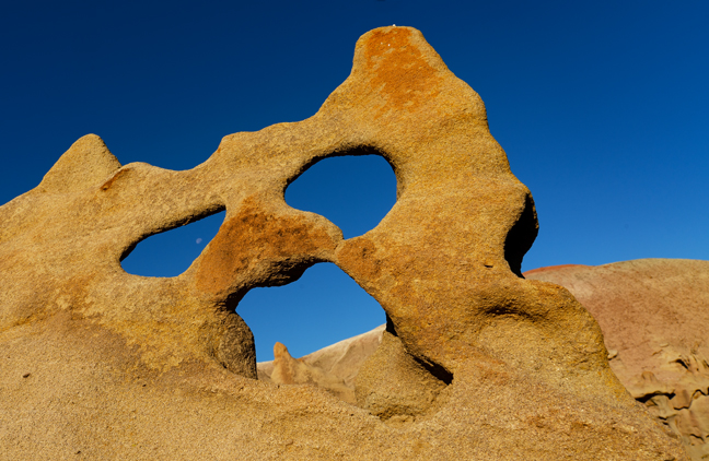
Fantasy Canyon (12T-636951-443541)
Scholars believe that Edvard Munch’s inspiration for “The Scream” came from when he was out for a walk along a fjord overlooking Oslo, Norway in 1893. A better explanation is that he saw this formation in Fantasy Canyon. If he had been on the fantasy world of Gaia, he could have seen moons in both eyes.... After all, it is called Fantasy Canyon. (2/2)
©Rich Beckman
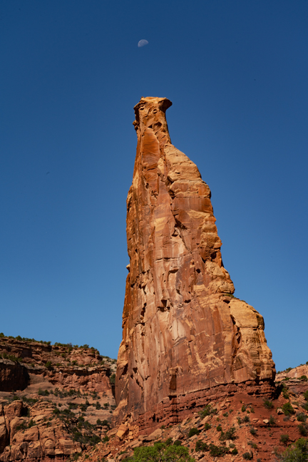
Moonset, Sentinel Spire, Colorado National Monument
We were joined by friends Marilyn and Joel for the first part of our week-long stay in Fruita, CO. We had previously hiked with them in Fruita, Utah, so it seemed appropriate that we would cross another Fruita of our list. Of course, there are also cities named Fruita in Oregon and Florida, so we are only half done.
Fruita, CO borders the Colorado National Monument and the McInnis Canyons National Conservation Area. The 31-square mile Monument, established in 1911, is an area of high desert, deep canyons and tall monoliths on the northeast side of the vast Colorado Plateau. The McInnis Canyons National Conservation Area includes Rattlesnake Canyon where the second largest concentration of natural arches outside of Utah’s Arches National Park exists.
In spite of daytime highs approaching 100 degrees, we hiked the Liberty Cap Trail to CO-214 arch and Otto’s Bathtub and the Monument Canyon Trail with Marilyn and Joel. Then we hiked to Tabeguache and Bench Trail Arches on our own and to Rattlesnake Canyon with Dave Kennedy, a friend from the Natural Arch and Bridge Society who lives in the area.
Sentinel Spire is a 200-foot freestanding Wingate Sandstone tower located in Wedding Canyon along the six-mile Monument Canyon Trail.
©Rich Beckman
Arch CO-214 (12S-697339-4324608, 5.5’ (largest opening)), Colorado National Monument
CO-214 is a waterfall natural bridge eroded through stacked bedding planes of Entrada sandstone (thanks Jay). The arches were known locally as Triple Bridge for several years, but now a fourth opening has developed. To get to the arches, follow the Liberty Cap Trail (starting at the west Liberty Cap Trailhead) for about a mile and turn to the right after about a mile at 12S-697133-4324921. The arches are situated on the canyon rim across from Suction Point (thanks Dave).
©Rich Beckman
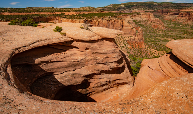
Otto’s Bathtub (12S-699279-4326838), Colorado National Monument
Otto’s Bathtub is named for John Otto, the man most responsible for the establishment of Colorado National Monument and its first superintendent in 1911. It is located on Monument Mesa in a cliff that caps the east rim of Monument Canyon. It is not known whether the basin was truly for bathing or for catching fresh water, but the chiseled out steps are well worn and no longer safe for descending into the basin. With the additional detour to CO-214, it was a 9.7 mile out-and-back hike and the tub was devoid of water, so there wasn’t even a soak along the way.
©Rich Beckman
Tabeguache Arch, also known as Wombat Arch (12S-718517-4316386, 35’x20’), Whitewater, CO
The trailhead is off CO141 just past Whitewater, CO. Turn right at the north end of the bridge over East Creek and park near the Jeep Tabeguache Trail sign. Apparently, construction of this section of the Jeep trail began in 2016 and is complete, but a locked gate prevented access. The Tabeguache Trail is a 141-mile-long trail that crosses western Colorado between Montrose and Grand Junction. It is open to hiking, as well as biking (in most places) and motorized use (in some places). The trail gets its name from the Tabeguache Band of Utes, who lived in the Grand Junction area until the Ute Removal Act of 1881 forced them off their ancestral land of 12,000 years.
There are two obvious trails to the top of the ridge from the parking area. When you get to the ridge line a bit more than a mile out, you can see the arch across the wash on the other side of the canyon. Finding a path to the arch is more of a mystery. There are supposedly faint trails to follow, but not finding them, we took a direct route, stumbling down one side of the canyon and scrambling up the other side. We got to the arch in nice morning light with only minor cuts and scrapes. Fortunately, we found a much easier return route a bit further down the canyon.
©Rich Beckman
Head of the Rattlesnake, Rattlesnake Canyon, McInnis Canyons National Conservation Area
Rattlesnake Canyon is thought to house 35 natural arches, second only to Arches National Park for the largest concentration of natural arches in the world. This is one of those places where the arches are fairly easy to walk to once you get there. Getting there is never easy and sometimes not possible. The 13-miles drive on Black Ridge Access Road just west of the Colorado National Monument requires high clearance and 4WD, and in good weather it takes about an hour. If it is raining or recently rained, the road is usually not passable.
There are two roads that parallel the southern boundary that are seasonally open to motorized travel. The Upper Road is open from April 15 - August 15, while the Lower Road is open from August 16 - February 15. Both roads are closed to motorized travel from February 15 - April 15. From Fruita it’s 11 miles from the Monument entrance station to the turn to "Glade Park Store," then .2 miles to the parking area and the start of the access road. You can also get to Rattlesnake Canyon from the Pollock Bench trial, but it’s a strenuous 15.5 miles out-and-back hike if you continue to the lower arches trail.
We met Dave Kennedy at the parking area at 6 a.m. and, knowing the road, he volunteered to drive. As predicted, we reached the trailhead at about 7 a.m. and descended into the canyon. The descent from the top of the mesa to the bench below is steep and rocky, but once you reach the lower arches trailhead, it is an easy walk. In the early morning, most of the arches are shaded, but in the summer, the afternoon temperatures reach 100 degrees, so there’s no ideal time to visit. Spring and fall are better options, but it is spectacular at any time.
©Rich Beckman
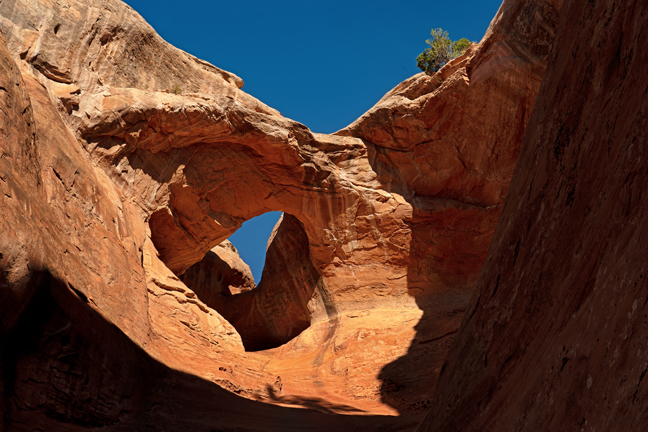
Centennial Arch (12S-686036-4335008, 120’x65’), Rattlesnake Canyon, McInnis Canyons National Conservation Area
©Rich Beckman
Trap Arch (12S-0686353-433459608, 32’x22’), Rattlesnake Canyon, McInnis Canyons National Conservation Area
©Rich Beckman
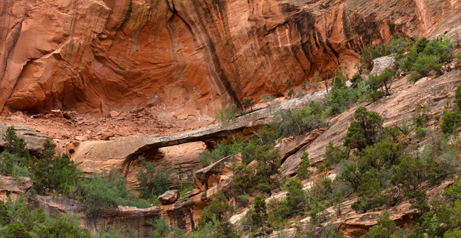
Bench Trail Arch (12S-700-483-4326949, 20’), Rattlesnake Canyon, McInnis Canyons National Conservation Area
After many challenging hikes in hot weather, we decided on an easier hike for our final day. We started at the east Liberty Cap Trailhead in Redlands, CO and followed it uphill for about a mile until we reached Bench Trail. We then followed Bench Trail in search of Bench Trail Arch. We knew that it spanned the lower part of a large alcove in a nearby side canyon and the GPS showed it be about .9 miles down the trail. Actually, it’s a backcountry trail that wasn’t clearly marked on the GPS, so what we really knew was that it was about .9 miles to the northwest of our location. The GPS forgot to mention the mountain that we would have to circumvent to get to the arch or that the arch was high off the trail and required significant bushwhacking to reach.
After a bit more than seven miles we returned to the trailhead. That evening, we had a lovely dinner at Dave and Judy Kennedy’s house in Glade Park, admired their lovely gardens and enjoyed a beautiful sunset on our drive home through the Monument.
©Rich Beckman
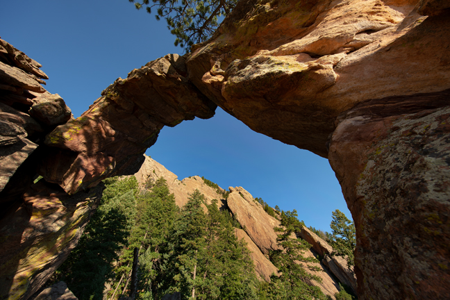
Royal Arch (13S-475169-4425793, 20’x20’), Boulder, CO
We departed the next morning for Boulder, where we would climb to Royal Arch and then have lunch with Ross Taylor.
The trailhead to Royal Arch is reached from Chautauqua Park, an historic landmark at the foot of the Flatiron Mountains, dating back to when the city of Boulder began preserving wilderness more than 100 years ago. The trail was under construction and closed M-Th 8 a.m. to 4 p.m. We arrived at sunrise and were well past the closure on our way back down before the work crews arrived. Currently, the upper portion of the trail is a scramble, but the most difficult climbs will be stepped once construction is finished. There’s a 1,400 elevation gain on the 1.5 mile climb to reach the arch.
I’ve known Ross for 30 years, since he was one of my photojournalism students and lab assistants at UNC-CH. Our paths rarely cross, so it was a wonderful reunion.
After lunch, we headed down to Denver to have dinner with Katie and Greg. Cynny and Katy have been friends since college. Then we headed to Littleton to spend a few days with Bob and Carol that included a couple of White Sox games against the Rockies. Bob retired about the same time I did after more than 45 years in journalism and education, outlasting me by three years.
After a wonderful visit with Bob and Carol and another inept performance by the White Sox, we headed to Del Norte, CO with planned stops at Great Sand Dunes National Park and Preserve, La Ventana Arch and Zapata Falls. Heavy storms prevented us from visiting any of those locations so we continued on the next day to Las Vegas, NM for an overnight stay with Carol, another of Cynny’s long-time friends.
From there we continued on to Taos for no particular reason other than to explore the town and from there to Abiquiu where the weather finally cleared for our visit to Ghost Ranch, the home and studio of Georgia O'Keeffe, as well as the subject of many of her paintings.
©Rich Beckman
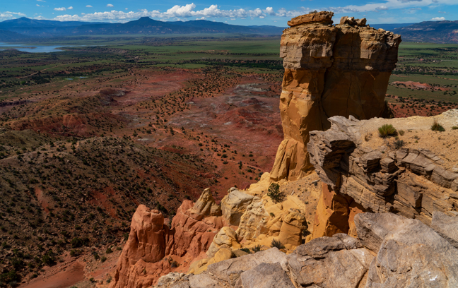
Chimney Rock, Ghost Ranch, Abiquiu, NM
In the morning, we hiked the Chimney Rock Trail. It’s about a three-mile hike with 600-feet of elevation gain that provides views across to Pedernal and the Piedra Lumbre basin, the heart of Georgia O'Keefe country. The hike circles around Chimney Rock climbing up to the top of the mesa adjacent to the formation.
©Rich Beckman
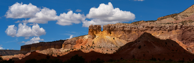
View of El Monte Rojo from Ghost Ranch, Abiquiu, NM
That afternoon, after a picnic lunch on the museum patio, we took the Ranch’s Georgia O’Keeffe Landscape Tour. The narrated tour takes you to sites that O’Keeffe painted while living at Ghost Ranch. Along the route, the guide shares reproductions of O’Keeffe paintings at the actual sites. The trees she painted have grown, but little else has changed, so it’s an interesting way to share her art and surrounding landscapes.
©Rich Beckman
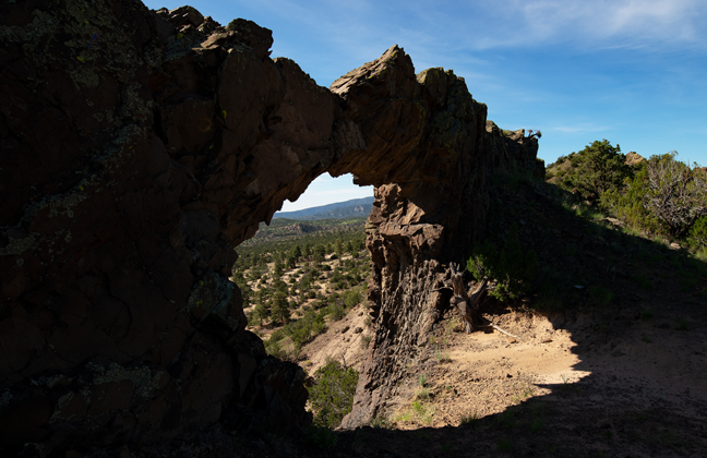
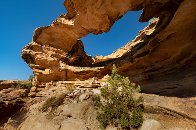
Window Rock NM-445 (13S-0390395-3998650, 30’x15’), Santa Fe National Forest, NM
After spending a relaxing day at Ghost Ranch, we headed out the next morning at sunrise for Window Rock. There are at least 20 catalogued arches named Window Rock. This one requires a 3.5 mile hike in Arroyo de las Lemitas in the Santa Fe National Forest to reach the cliff and then a half mile climb to the arch. The last quarter mile follows a narrow, steep social trail that climbs to the top of the ridge and then to the arch that sits on the edge of the ridge. You can’t walk through the arch as there is a steep drop-off. The trail takes you around the “back” of the arch that is backlit in the morning.
You can shorten the hike a bit by following the ATV tracks rather than staying in the arroyo the entire hike.
©Rich Beckman
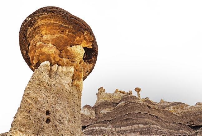
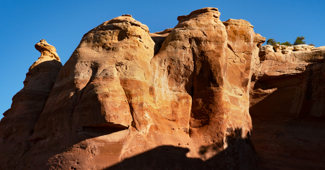
Lybrook Fossil Area (Badlands), Counselor, NM
This is the southernmost of the named New Mexico Badlands, located about 20 miles northeast of Chaco Culture National Historic Park. The closest hotels are in Farmington more than an hour to the north, but we rented a lovely Navajo Hogan on a Christian Mission Campus near Counselor, NM (VRBO) Property ID: 2335000) that is less than 10 miles from the turn onto CR7900. Since it is BLM land, you could also camp right in the Badlands, although there are no facilities. The unnamed oil field roads into the center of the area require high clearance 4WD.
We were guided by Peter Jamieson, a Natural Arch and Bridge colleague, who drove down from Durango to meet us. Thanks Peter! It was a cloudy morning with little, if any, sunlight, so it was less than ideal for photography, but nice for hiking and learning the area. The area is characterized by rolling mounds of mud and siltstones with interdispersed sandstones. The hoodoos are massive in comparison to those in the Bisti, although the Bisti and De-Na-Zin Badlands have a greater geologic variety. (If you are visiting the De-Na-Zin area, do not attempt to access the parking area from the east off of NM371. County Road 7023 is closed from the east because much of the road has been washed away. It was possible (and fun) with a high clearance 4WD vehicle, but there are a few sections that were dangerous and it will likely get worse as the monsoon rains continue. In some sections there are steep drops on either side of what is left of the road and a few steep drops and rises into sandy ditches that required 4WD low.)
©Rich Beckman
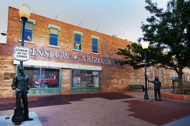
Standing on a Corner in Winslow, AZ (West 2nd Ave. and Kinsey Ave.)
We made one more stop before arriving back home in Tucson. Because we live in Arizona and because Winslow, AZ is halfway between the Badlands and home and because we enjoy Jackson Browne and The Eagles, we scheduled a stop so that we could “Take It Easy” in Winslow, AZ.
“Well, I’m standing on a corner in Winslow, AZ
And such a fine sight to see
It’s a girl, my Lord, in a flatbed Ford
Slowin’ down to look at me”
During 1960’s Winslow was the largest town in northern Arizona. It was headquarters for the Santa Fe Railway and home to the massive Hubble Trading Post warehouse, part of a vast trading empire of Native American wares and home La Posada, the finest Harvey Hotel in the Southwest, which opened in 1929 and cost $40 million in today’s dollars.
La Posada shut its doors in 1957 and Route 66 was decommissioned in 1985 and replaced by I-40 that bypassed Winslow. After it closed, the hotel languished for years as the Santa Fe Railway offices. It was slated for demolition when Allan Affeldt convinced the railway to sell it to him. It cost more than $12 million to renovate and today is once again a classic grand hotel. Rooms are named for famous guests that included Albert Einstein, Amelia Earhart, Betty Grable, Clark Gable, Jimmy Stewart, John Wayne, Presidents Franklin Roosevelt and Harry Truman, Shirley Temple and Will Rogers amongst a long list. We stayed in the Roy Rogers Room.
The town nearly disappeared after the completion of I-40. One by one the decades-old downtown shops began to close. For the next twenty years, Winslow faded into obscurity.
Then, as the legend goes, Jackson Browne had car trouble on the way to or from Sedona and spent a day in Winslow. He wrote most of the song, but Glenn Frey contributed the lyric, “It’s a girl, my lord, in a flatbed Ford, slowin’ down to take a look at me.” Browne said, “I had dug the fact that all these women in Arizona were driving trucks. It appealed to me.”
On May 29th, 1997, the Standin’ on the Corner Foundation took the first steps to develop a park at the heart of downtown Winslow that would commemorate the song, the Eagles first single, “Take it Easy.” The project resulted in the Standin’ on the Corner Park that was dedicated on September 10th, 1999. It originally included the two-story, Trompe-l’œil style mural by John Pugh and a life-sized bronze statue by Ron Adamson named “Easy.”
On October 18, 2004, there was a fire at the Standin' on the Corner Park. While the face of the building and the actual corner survived, the rest of the building burned down. The remaining wall had to be stabilized and the mural, painted on panels attached to the wall, had to be re-done. Between insurance claims, building permits and restoration, the park was surrounded by a chain-link fence for years.
When Glenn Frey, a founding member of the Eagles, died on January 18th, 2016, the Standin’ on The Corner Foundation commissioned a new statue to be installed on The Corner next to “Easy” in his memory.
This year’s Standing on the Corner Festival will be held on September 23 and 24, 2022.
©Rich Beckman